File:Gorbals railway station (site), Glasgow (geograph 6220431).jpg
Jump to navigation
Jump to search

Size of this preview: 800 × 600 pixels. Other resolutions: 320 × 240 pixels | 640 × 480 pixels | 1,024 × 768 pixels | 1,280 × 960 pixels | 1,600 × 1,200 pixels.
Original file (1,600 × 1,200 pixels, file size: 400 KB, MIME type: image/jpeg)
Captions
Captions
Add a one-line explanation of what this file represents
Summary[edit]
,_Glasgow_(geograph_6220431).jpg&action=edit§ion=1)
| Description |
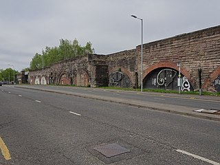
English: Gorbals railway station (site), Glasgow Opened in 1877 by the Glasgow Barrhead & Kilmarnock Joint Railway, later part of both the Caledonian and Glasgow & South Western Railways, when the line from Kilmarnock to Southside station was extended northwards to a new terminus at Glasgow St. Enoch. Gorbals was the only intermediate station and was close to the old station at Southside. It was also adjacent to Main Street Station. View south west from Lauriston Road. The platforms had been on the viaduct here, but it no longer carried a railway line when this image was taken. |
| Date | |
| Source | From geograph.org.uk |
| Author | Nigel Thompson |
| Permission (Reusing this file) |
Creative Commons Attribution Share-alike license 2.0 |
| Attribution (required by the license) | Nigel Thompson / Gorbals railway station (site), Glasgow / |
| Camera location | | View this and other nearby images on: OpenStreetMap |
|---|
,_Glasgow_(geograph_6220431).jpg¶ms=055.848718_N_-004.253233_E_globe:Earth_type:camera_source:geograph-osgb36(NS59036402)_heading:225.00&language=en)
| Object location | | View this and other nearby images on: OpenStreetMap |
|---|
,_Glasgow_(geograph_6220431).jpg¶ms=055.848430_N_-004.254170_E_globe:Earth_class:object_type:object_source:geograph-osgb36(NS58976399)_heading:225.00&language=en)
Licensing[edit]
,_Glasgow_(geograph_6220431).jpg&action=edit§ion=2)

|
This image was taken from the Geograph project collection. See this photograph's page on the Geograph website for the photographer's contact details. The copyright on this image is owned by Nigel Thompson and is licensed for reuse under the Creative Commons Attribution-ShareAlike 2.0 license.
|
This file is licensed under the Creative Commons Attribution-Share Alike 2.0 Generic license.
Attribution: Nigel Thompson
- You are free:
- to share – to copy, distribute and transmit the work
- to remix – to adapt the work
- Under the following conditions:
- attribution – You must give appropriate credit, provide a link to the license, and indicate if changes were made. You may do so in any reasonable manner, but not in any way that suggests the licensor endorses you or your use.
- share alike – If you remix, transform, or build upon the material, you must distribute your contributions under the same or compatible license as the original.
File history
Click on a date/time to view the file as it appeared at that time.
| Date/Time | Thumbnail | Dimensions | User | Comment | |
|---|---|---|---|---|---|
| current | 22:53, 4 January 2020 | | 1,600 × 1,200 (400 KB) | Lamberhurst (talk | contribs) | Transferred from geograph.co.uk using [https://tools.wmflabs.org/geograph2commons/ geograph2commons] |
You cannot overwrite this file.
File usage on Commons
The following page uses this file:
File usage on other wikis
The following other wikis use this file:
- Usage on en.wikipedia.org
,_Glasgow_(geograph_6220431).jpg&oldid=713099009)