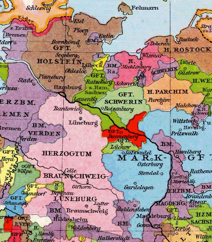
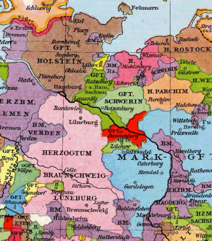
File:Grafschaften Holstein Ratzeburg Schwerin Dannenberg Luechow 1250.png
Původní soubor (700 × 796 pixelů, velikost souboru: 284 KB, MIME typ: image/png)
Popisky
Popisky

|
K tomuto obrázku existuje vektorová verze (v SVG). Pokud je lepší, používejte raději tu.
File:Grafschaften Holstein Ratzeburg Schwerin Dannenberg Luechow 1250.png → File:Grafschaften Holstein Ratzeburg Schwerin Dannenberg Luechow 1250.svg
Podrobnější informace o vektorové grafice najdete na stránce Commons:Transition to SVG. Také si můžete přečíst informace o podpoře formátu SVG v MediaWiki. |
 |
| Popis | |||||
| Datum | |||||
| Zdroj |
Deutsch: Allgemeiner historischer Handatlas |
||||
| Autor | Gustav Droysen | ||||
| Svolení (Užití tohoto souboru) |
|
||||
| Další verze |
Díla odvozená od tohoto souboru: Północno-wschodnie Niemcy ok 1250.svg Image:Grafschaft_Dannenberg_1250.png, Image:Grafschaft Dannenberg um 1250.PNG |
||||
Historie souboru
Kliknutím na datum a čas se zobrazí tehdejší verze souboru.
| Datum a čas | Náhled | Rozměry | Uživatel | Komentář | |
|---|---|---|---|---|---|
| současná | 4. 10. 2007, 21:25 | | 700 × 796 (284 KB) | Torsten Bätge (diskuse | příspěvky) | {{Information |Description={{de|Grafschaften Holstein, Ratzeburg, Schwerin, Dannenberg und Lüchow um 1250.}} |Source={{de|Allgemeiner historischer Handatlas}} |Date=1886 |Author=Gustav Droysen |P |
Tento soubor nemůžete přepsat.
Využití souboru
Na Commons na soubor odkazují tyto stránky:
Globální využití souboru
Tento soubor využívají následující wiki:
- Využití na arz.wikipedia.org
- Využití na bg.wikipedia.org
- Využití na br.wikipedia.org
- Využití na cs.wikipedia.org
- Využití na cy.wikipedia.org
- Využití na da.wikipedia.org
- Využití na da.wikibooks.org
- Využití na el.wikipedia.org
- Využití na en.wikipedia.org
- Využití na et.wikipedia.org
- Využití na it.wikipedia.org
- Využití na lv.wikipedia.org
- Využití na mk.wikipedia.org
- Využití na no.wikipedia.org
- Využití na ru.wikipedia.org
- Využití na www.wikidata.org
- Landkreis Lüchow-Dannenberg
- Maps of territories in the Lower Saxony Circle
- Maps of Lübeck prince-bishopric
- Maps of Ratzeburg prince-bishopric
- Bishopric of Schwerin
- Old maps of Lübeck
- Maps of Saxe-Lauenburg
- Maps pieces from Allgemeiner Historischer Handatlas
- Maps showing history of the High Middle Ages
- County of Schwerin
- Maps of Holstein
- Duchy of Brunswick-Lüneburg