File:Großsteingrab Groß Labenz 1 FoP.jpg
Jump to navigation
Jump to search

Size of this preview: 800 × 509 pixels. Other resolutions: 320 × 204 pixels | 640 × 407 pixels | 1,024 × 652 pixels | 1,280 × 815 pixels | 2,080 × 1,324 pixels.
Original file (2,080 × 1,324 pixels, file size: 1.23 MB, MIME type: image/jpeg)
Captions
Captions
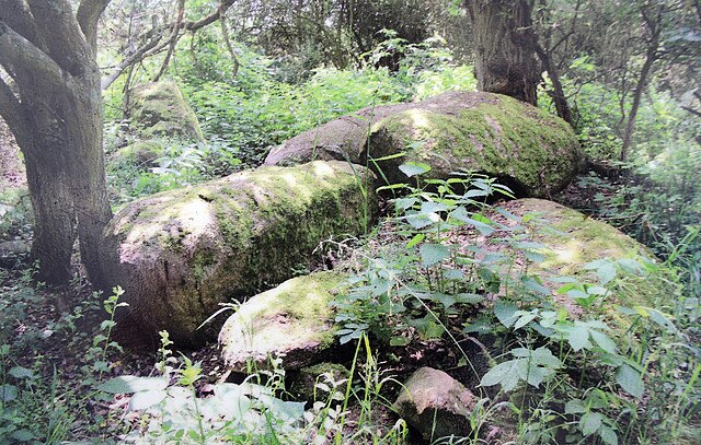
Großsteingrab Groß Labenz 1
Summary[edit]
| Description |
English: The megalithic tomb Groß Labenz 1 in Germany
Deutsch: Das neolithische Großsteingrab Groß Labenz 1 |
| Date | |
| Source | The source is a public roadside information board near Groß Labenz, Germany |
| Author | The author is unknown, but the information board has been published by the municipality of Warin, Germany. |
| Camera location | | View this and other nearby images on: OpenStreetMap |
|---|
Licensing[edit]
|
The photographical reproduction of this work is covered under the article § 59 of the German copyright law, which states that "It shall be permissible to reproduce, by painting, drawing, photography or cinematography, works which are permanently located on public ways, streets or places and to distribute and publicly communicate such copies. For works of architecture, this provision shall be applicable only to the external appearance."
As with all other “limits of copyright by legally permitted uses”, no changes to the actual work are permitted under § 62 of the German copyright law (UrhG). See Commons:Copyright rules by territory/Germany#Freedom of panorama for more information.
|
And for the reproduction:
| This file is made available under the Creative Commons CC0 1.0 Universal Public Domain Dedication. | |
| The person who associated a work with this deed has dedicated the work to the public domain by waiving all of their rights to the work worldwide under copyright law, including all related and neighboring rights, to the extent allowed by law. You can copy, modify, distribute and perform the work, even for commercial purposes, all without asking permission.
|
File history
Click on a date/time to view the file as it appeared at that time.
| Date/Time | Thumbnail | Dimensions | User | Comment | |
|---|---|---|---|---|---|
| current | 17:42, 28 May 2023 | | 2,080 × 1,324 (1.23 MB) | Cephyr~commonswiki (talk | contribs) | Uploaded a work by The author is unknown, but the information board has been edited by the municipality of Warin, Germany. from The source is a public roadside information board near Groß Labenz, Germany with UploadWizard |
You cannot overwrite this file.
File usage on Commons
There are no pages that use this file.
File usage on other wikis
The following other wikis use this file: