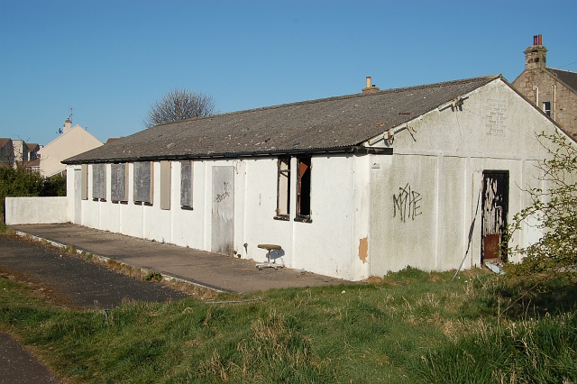
File:Guardroom, RAF Anstruther - geograph.org.uk - 159401.jpg
Guardroom,_RAF_Anstruther_-_geograph.org.uk_-_159401.jpg (640 × 426 pixels, file size: 247 KB, MIME type: image/jpeg)
Captions
Captions
Summary[edit]
| DescriptionGuardroom, RAF Anstruther - geograph.org.uk - 159401.jpg |
English: Guardroom, RAF Anstruther The guardroom to the former domestic site of RAF Anstruther. Behind me were the barrack blocks for the RAF station which went on to see service as Anstruther's holiday village and have now been pulled down and a modern development is now taking place. The buildings to the right of the old guardroom on Toll Road were married quarters for other ranks.
RAF Anstruther was part of the Chain Home system (CH). Chain Home was the world's first RADAR system to see active service. CH was developed in the pre war years by a team lead by Watson Watt who to my mind was a bit of an unsung hero of the time. It was primitive, but when your back's against the wall you go with what you have got. In 1939 Britain did and CH worked. RAF Anstruther's operational site and its masts were, to the best of my ability, thought to have been in the area of NO5608. This area went on to become the site of the cold war "secret bunker". Totally open to corrections please email me via the site. Thanks to James Allan and Dennis Anderson for further information about the station. |
| Date | |
| Source | From geograph.org.uk |
| Author | Jim Bain |
| Attribution (required by the license) InfoField | Jim Bain / Guardroom, RAF Anstruther / |
InfoField | Jim Bain / Guardroom, RAF Anstruther |
| Camera location | 56° 13′ 38″ N, 2° 41′ 28″ W | View this and other nearby images on: OpenStreetMap |
|---|
| Object location | 56° 13′ 38″ N, 2° 41′ 35″ W | View this and other nearby images on: OpenStreetMap |
|---|
Licensing[edit]

|
This image was taken from the Geograph project collection. See this photograph's page on the Geograph website for the photographer's contact details. The copyright on this image is owned by Jim Bain and is licensed for reuse under the Creative Commons Attribution-ShareAlike 2.0 license.
|
- You are free:
- to share – to copy, distribute and transmit the work
- to remix – to adapt the work
- Under the following conditions:
- attribution – You must give appropriate credit, provide a link to the license, and indicate if changes were made. You may do so in any reasonable manner, but not in any way that suggests the licensor endorses you or your use.
- share alike – If you remix, transform, or build upon the material, you must distribute your contributions under the same or compatible license as the original.
File history
Click on a date/time to view the file as it appeared at that time.
| Date/Time | Thumbnail | Dimensions | User | Comment | |
|---|---|---|---|---|---|
| current | 08:35, 31 January 2010 |  | 640 × 426 (247 KB) | GeographBot (talk | contribs) | == {{int:filedesc}} == {{Information |description={{en|1=Guardroom, RAF Anstruther The guardroom to the former domestic site of RAF Anstruther. Behind me were the barrack blocks for the RAF station which went on to see service as Anstruther's holiday vill |
You cannot overwrite this file.
File usage on Commons
There are no pages that use this file.
File usage on other wikis
The following other wikis use this file:
- Usage on kk.wikipedia.org
Metadata
This file contains additional information such as Exif metadata which may have been added by the digital camera, scanner, or software program used to create or digitize it. If the file has been modified from its original state, some details such as the timestamp may not fully reflect those of the original file. The timestamp is only as accurate as the clock in the camera, and it may be completely wrong.
| Camera manufacturer | NIKON CORPORATION |
|---|---|
| Camera model | NIKON D50 |
| Exposure time | 1/400 sec (0.0025) |
| F-number | f/11 |
| Date and time of data generation | 08:04, 27 April 2006 |
| Lens focal length | 26 mm |
| Orientation | Normal |
| Horizontal resolution | 300 dpi |
| Vertical resolution | 300 dpi |
| Software used | Ver.1.00 |
| File change date and time | 08:04, 27 April 2006 |
| Y and C positioning | Co-sited |
| Exposure Program | Not defined |
| Exif version | 2.21 |
| Date and time of digitizing | 08:04, 27 April 2006 |
| Image compression mode | 4 |
| APEX exposure bias | 0 |
| Maximum land aperture | 4 APEX (f/4) |
| Metering mode | Pattern |
| Light source | Unknown |
| Flash | Flash did not fire, compulsory flash suppression |
| DateTime subseconds | 60 |
| DateTimeOriginal subseconds | 60 |
| DateTimeDigitized subseconds | 60 |
| Color space | sRGB |
| Sensing method | One-chip color area sensor |
| Custom image processing | Normal process |
| Exposure mode | Auto exposure |
| White balance | Auto white balance |
| Digital zoom ratio | 1 |
| Focal length in 35 mm film | 39 mm |
| Scene capture type | Landscape |
| Contrast | Normal |
| Saturation | Normal |
| Sharpness | Hard |
| Subject distance range | Unknown |
