File:Gunung Klabat.jpg
跳转到导航
跳转到搜索
没有更高的分辨率。
Gunung_Klabat.jpg (640 × 428像素,文件大小:52 KB,MIME类型:image/jpeg)
说明
说明
添加一行文字以描述该文件所表现的内容
| 描述 |
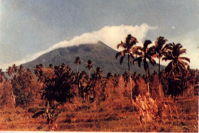
English: Weather clouds drape the summit of Gunung Klabat, an isolated symmetrical stratovolcano that rises to 1995 m near the eastern tip of the northern arm of Sulawesi. Klabat, rising above the farming village of Tatelu below its NW flank, has a shallow lake in its 170 x 250 m summit crater. No verified historical eruptions have occurred from Klabat volcano, the highest peak in northern Sulawesi. |
|||
| 日期 | ||||
| 来源 | http://www.volcano.si.edu/world/volcano.cfm?vnum=0606-12=&volpage=photos&photo=063054 | |||
| 作者 | S. Wikartadipura (Volcanological Survey of Indonesia) | |||
| 授权 (二次使用本文件) |
|

文件历史
点击某个日期/时间查看对应时刻的文件。
| 日期/时间 | 缩略图 | 大小 | 用户 | 备注 | |
|---|---|---|---|---|---|
| 当前 | 2010年7月26日 (一) 17:07 | | 640 × 428(52 KB) | Michael Metzger(留言 | 贡献) | {{Information |Description={{en|1=Weather clouds drape the summit of Gunung Klabat, an isolated symmetrical stratovolcano that rises to 1995 m near the eastern tip of the northern arm of Sulawesi. Klabat, rising above the farming village of Tatelu below i |
您不可以覆盖此文件。
文件用途
以下2个页面使用本文件:
全域文件用途
以下其他wiki使用此文件:
- ca.wikipedia.org上的用途
- cs.wikipedia.org上的用途
- de.wikipedia.org上的用途
- en.wikipedia.org上的用途
- es.wikipedia.org上的用途
- eu.wikipedia.org上的用途
- fr.wikipedia.org上的用途
- id.wikipedia.org上的用途
- ja.wikipedia.org上的用途
- jv.wikipedia.org上的用途
- ko.wikipedia.org上的用途
- lv.wikipedia.org上的用途
- ms.wikipedia.org上的用途
- pl.wikipedia.org上的用途
- pt.wikipedia.org上的用途
- sk.wikipedia.org上的用途
- uk.wikipedia.org上的用途
- www.wikidata.org上的用途
- zh.wikipedia.org上的用途