File:HRR 14Jh.jpg
Pāriet uz navigāciju
Pāriet uz meklēšanu
Šī priekšskata izmērs: 471 × 599 pikseļi. Citi izmēri: 189 × 240 pikseļi | 377 × 480 pikseļi | 604 × 768 pikseļi | 805 × 1 024 pikseļi | 1 384 × 1 760 pikseļi.
Sākotnējais fails (1 384 × 1 760 pikseļi, faila izmērs: 728 KB, MIME tips: image/jpeg)
Captions
Captions
Pievieno vienas rindiņas aprakstu, ko šis fails attēlo
| Apraksts |
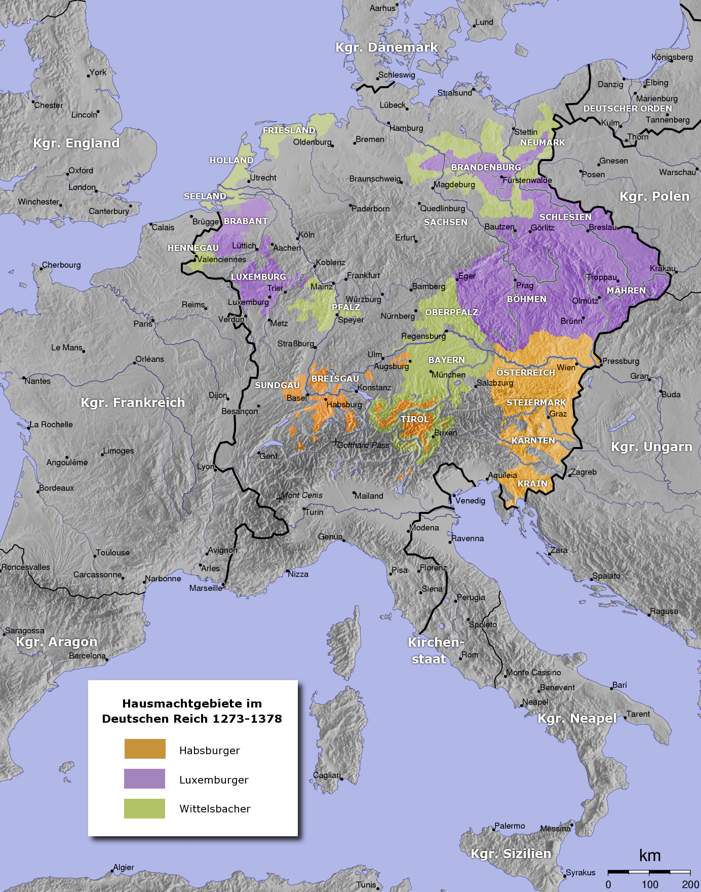
Deutsch: Holy Roman Empire in the 14th century. Deutsch: Das Heilige Römische Reich im 14. Jahrhundert. |
| Datums | |
| Avots | Paša darbs (see uploaders comment) |
| Autors | User:Captain Blood |
| Citas versijas | العربيَّة |

|
This file has been superseded by HRR 14Jh.png. It is recommended to use the other file. Please note that deleting superseded images requires consent. Reason to use the other file: "The legend was corrected"
|

|

|
This historical map image could be re-created using vector graphics as an SVG file. This has several advantages; see Commons:Media for cleanup for more information. If an SVG form of this image is available, please upload it and afterwards replace this template with
{{vector version available|new image name}}.
It is recommended to name the SVG file “HRR 14Jh.svg”—then the template Vector version available (or Vva) does not need the new image name parameter. |


|
This map has been uploaded by Electionworld from de.wikipedia.org to enable the |
The map has been created with the Generic Mapping Tools: https://www.generic-mapping-tools.org/ using one or more of these public-domain datasets for the relief:
|

|
Ir dota atļauja kopēt, izplatīt un/vai pārveidot šo dokumentu saskaņā ar GNU brīvās dokumentācijas licences, versijas 1.2 vai jebkuras vēlākas versijas, ko publiskojis Brīvās programmatūras fonds nosacījumiem; bez nemainīgajām sadaļā, priekšējā un aizmugurēja'vāka tekstiem. Licences kopija ir iekļauta sadaļā ar nosaukumu GNU brīvās dokumentācijas licence. |
| Šis fails tiek izplatīts saskaņā ar licences Creative Commons Atsauce-Līdzīgi Noteikumi 3.0 Vispārējiem noteikumiem. | ||
| ||
| This licensing tag was added to this file as part of the GFDL licensing update. |
derivative works[labot šo sadaļu]
Derivative works of this file: Kingdom of Bohemia in 14th Century (German).jpg
.jpg)
Faila hronoloģija
Uzklikšķini uz datums/laiks kolonnā esošās saites, lai apskatītos, kā šis fails izskatījās tad.
| Datums/Laiks | Attēls | Izmēri | Dalībnieks | Komentārs | |
|---|---|---|---|---|---|
| tagadējais | 2013. gada 11. marts, plkst. 13.16 | | 1 384 × 1 760 (728 KB) | Ras67 (diskusija | devums) | losslessly cropped with Jpegcrop |
| 2007. gada 1. janvāris, plkst. 22.29 |  | 1 400 × 1 774 (747 KB) | Electionworld (diskusija | devums) | {{ew|de|Captain Blood}} {{Bild-GFDL-GMT}} Category:Maps to be added to the atlas |
Šo failu nevar pārrakstīt.
Faila lietojums
Šo failu izmanto šajās 12 lapās:
- Atlas of Austria
- Atlas of Belgium
- Atlas of Germany
- Atlas of Italy
- Atlas of Luxembourg
- Atlas of Switzerland
- Atlas of the Czech Republic
- Atlas of the Netherlands
- Top 200 JPG images that should use vector graphics
- File:HRR 14Jh-ar.jpg
- File:HRR 14Jh.png
- File:Kingdom of Bohemia in 14th Century (German).jpg
Globālais faila lietojums
Šīs Vikipēdijas izmanto šo failu:
- Izmantojums ar.wikipedia.org
- Izmantojums ast.wikipedia.org
- Izmantojums azb.wikipedia.org
- Izmantojums ba.wikipedia.org
- Izmantojums be-tarask.wikipedia.org
- Izmantojums be.wikipedia.org
- Izmantojums ca.wikipedia.org
- Izmantojums cs.wikipedia.org
- Izmantojums da.wikipedia.org
- Izmantojums de.wikipedia.org
- 1322
- 1373
- Karl IV. (HRR)
- Wittelsbach
- Ludwig IV. (HRR)
- Haus Luxemburg
- Friedrich der Schöne
- Hausmachtpolitik
- Deutschland im Mittelalter
- Schlacht bei Mühldorf
- Diskussion:Liste der höchsten Berge in Deutschland
- Stephan II. (Bayern)
- Diskussion:Bulgarien/Archiv/1
- Böhmen am Meer
- Geschichte Dornbirns
- Wikipedia:Kartenwerkstatt/Hilfe/GMT
- Schweizer Habsburgerkriege
- Rüdiger von Sparneck
- Vertrag von Fürstenwalde
- Benutzer:Sababu~dewiki/Spielwiese
- Benutzer:Der Eberswalder/Vorlage:Testseite
- Benutzer:Methodios/Dresden 1517
- Wikipedia:Grafikwerkstatt/Archiv/2020/Januar
- Izmantojums el.wikipedia.org
- Izmantojums en.wikipedia.org
- Izmantojums es.wikipedia.org
Skatīt šī faila pilno globālo izmantojumu.