File:Haarlem1646.JPG
Jump to navigation
Jump to search

Size of this preview: 424 × 600 pixels. Other resolutions: 170 × 240 pixels | 339 × 480 pixels | 543 × 768 pixels | 724 × 1,024 pixels | 2,048 × 2,896 pixels.
Original file (2,048 × 2,896 pixels, file size: 2.78 MB, MIME type: image/jpeg)
Captions
Captions
Add a one-line explanation of what this file represents
Summary[edit]
| Map of Haarlem with environs. | |||||||||||||||||||||||||||||||||||||||||||||||||
|---|---|---|---|---|---|---|---|---|---|---|---|---|---|---|---|---|---|---|---|---|---|---|---|---|---|---|---|---|---|---|---|---|---|---|---|---|---|---|---|---|---|---|---|---|---|---|---|---|---|
| Author |
|
||||||||||||||||||||||||||||||||||||||||||||||||
| Title |
Map of Haarlem with environs. |
||||||||||||||||||||||||||||||||||||||||||||||||
| Description |
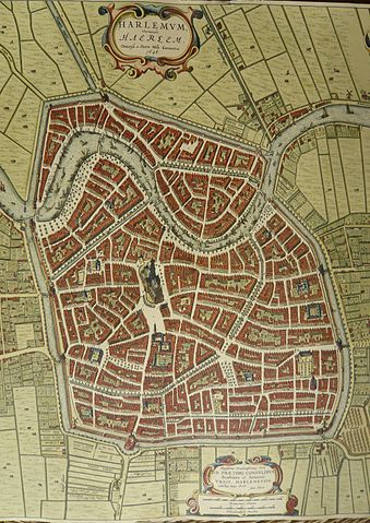
In 1642 the city council commissioned the surveyors Hendrik Duijndam and Peter Wils to design a new expansion on the north side of the city. Leiden and Amsterdam had expanded their borders in a similar fashion. The designers based their ideas on an idealised 'Italian' view of the ideal city. Salomon de Bray contributed his own plan, convincing the council that the northern expansion was just one step in realising a star-shaped ideal city that would surround the existing city walls in a star pattern with 16 bastions, with the cathedral in the center. Salomon de Bray's plan was partially executed on the North side, and his zigzag canals around the bastions still exist today. This map shows the situation before construction began. |
||||||||||||||||||||||||||||||||||||||||||||||||
| Date | 1646 | ||||||||||||||||||||||||||||||||||||||||||||||||
| Inscriptions | 'Harlemum Vernacule Haerlem Dimensa a Petro Wils Geometra 1646.' | ||||||||||||||||||||||||||||||||||||||||||||||||
| Notes | copper engraving by Joan Blaeu in Amsterdam 1649, scale in Rhijnlands roeden and Kennemer feet. | ||||||||||||||||||||||||||||||||||||||||||||||||
| Source/Photographer |
Self-made photo of 1997 reproduction of one of many copies of this map in possession of North Holland Archives. Archiefdienst voor Kennemerland/Historische Museum Zuid-Kennemerland, Haarlem |
||||||||||||||||||||||||||||||||||||||||||||||||
.jpg)
Licensing[edit]
|
This is a faithful photographic reproduction of a two-dimensional, public domain work of art. The work of art itself is in the public domain for the following reason:
The official position taken by the Wikimedia Foundation is that "faithful reproductions of two-dimensional public domain works of art are public domain".
This photographic reproduction is therefore also considered to be in the public domain in the United States. In other jurisdictions, re-use of this content may be restricted; see Reuse of PD-Art photographs for details. | ||||
Licensing[edit]
I, the copyright holder of this work, hereby publish it under the following licenses:

|
Permission is granted to copy, distribute and/or modify this document under the terms of the GNU Free Documentation License, Version 1.2 or any later version published by the Free Software Foundation; with no Invariant Sections, no Front-Cover Texts, and no Back-Cover Texts. A copy of the license is included in the section entitled GNU Free Documentation License. |
This file is licensed under the Creative Commons Attribution-Share Alike 4.0 International, 3.0 Unported, 2.5 Generic, 2.0 Generic and 1.0 Generic license.
- You are free:
- to share – to copy, distribute and transmit the work
- to remix – to adapt the work
- Under the following conditions:
- attribution – You must give appropriate credit, provide a link to the license, and indicate if changes were made. You may do so in any reasonable manner, but not in any way that suggests the licensor endorses you or your use.
- share alike – If you remix, transform, or build upon the material, you must distribute your contributions under the same or compatible license as the original.
You may select the license of your choice.
File history
Click on a date/time to view the file as it appeared at that time.
| Date/Time | Thumbnail | Dimensions | User | Comment | |
|---|---|---|---|---|---|
| current | 14:00, 9 November 2016 | | 2,048 × 2,896 (2.78 MB) | SteinsplitterBot (talk | contribs) | Bot: Image rotated by 270° |
| 13:58, 3 February 2008 |  | 2,902 × 2,048 (2.78 MB) | Jane023 (talk | contribs) | [[Category:]]{{Information |Description=Map of Haarlem with environs. In 1642 the city council commissioned the surveyors Hendrik Duijndam and Peter Wils to design a new expansion on the north side of the city. Leiden and Amsterdam had expanded their bord |
You cannot overwrite this file.
File usage on Commons
The following page uses this file:
File usage on other wikis
The following other wikis use this file:
- Usage on it.wikipedia.org