File:Hawaii hazard map-de.svg
Jump to navigation
Jump to search

Size of this PNG preview of this SVG file: 600 × 600 pixels. Other resolutions: 240 × 240 pixels | 480 × 480 pixels | 768 × 768 pixels | 1,024 × 1,024 pixels | 2,048 × 2,048 pixels | 1,965 × 1,965 pixels.
Original file (SVG file, nominally 1,965 × 1,965 pixels, file size: 800 KB)
Captions
Captions
Add a one-line explanation of what this file represents
Summary
[edit]
| Description |
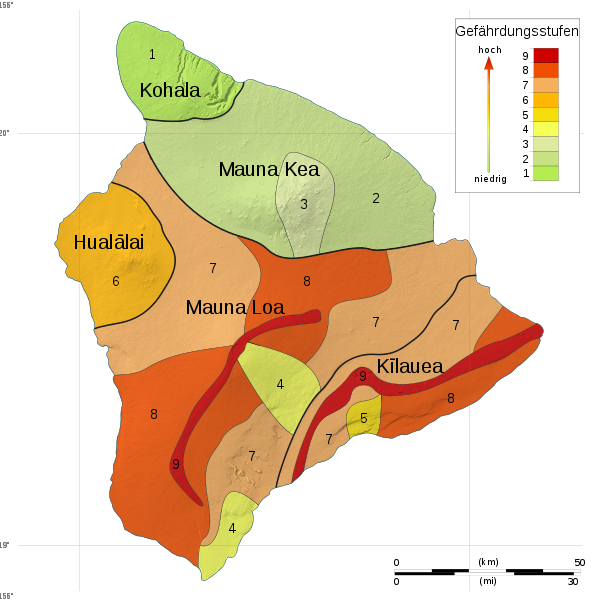
Deutsch: Karte der Gefährdungen durch Vulkanismus auf der Insel Hawaiʻi, Bundesstaat Hawaiʻi, Vereinigte Staaten von Amerika. |
|||
| Date | ||||
| Source | Hawaii hazard map-fr.svg | |||
| Author | Sémhur | |||
| Permission (Reusing this file) |
|
|||
| Other versions | Hawaii hazard map-fr.svg |

|
This SVG file contains embedded text that can be translated into your language, using any capable SVG editor, text editor or the SVG Translate tool. For more information see: About translating SVG files. |
This W3C-unspecified vector image was created with Inkscape .
Licensing
[edit]
This image is in the public domain in the United States because it only contains materials that originally came from the United States Geological Survey, an agency of the United States Department of the Interior. For more information, see the official USGS copyright policy.
|
File history
Click on a date/time to view the file as it appeared at that time.
| Date/Time | Thumbnail | Dimensions | User | Comment | |
|---|---|---|---|---|---|
| current | 07:51, 6 August 2010 | | 1,965 × 1,965 (800 KB) | ThT (talk | contribs) | {{Information |Description={{de|1=Karte der Gefährdungen durch Vulkanismus auf der Insel Hawai{{Okina}}i, Bundesstaat Hawaiʻi, Vereinigte Staaten von Amerika.}} |Source=Hawaii hazard map-fr.svg |
You cannot overwrite this file.
File usage on Commons
There are no pages that use this file.
File usage on other wikis
The following other wikis use this file:
- Usage on de.wikipedia.org