File:Hedschasbahn Uebersichtskarte.png
Jump to navigation
Jump to search

Size of this preview: 409 × 599 pixels. Other resolutions: 164 × 240 pixels | 327 × 480 pixels | 735 × 1,077 pixels.
Original file (735 × 1,077 pixels, file size: 1,015 KB, MIME type: image/png)
Captions
Captions
Add a one-line explanation of what this file represents
Summary
[edit]
| Description |
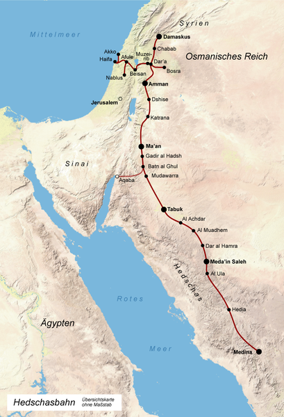
Deutsch: Übersichtskarte zum Verlauf der Hedschasbahn
English: Overview Map of the Hejaz (Damascus-Mecca) railway of the late Ottoman period |
| Date | 07.08.2007, korrigierte Version vom 14.11.2007 |
| Source | own work / selbst hergestellt; Base: Image:Ferrocarril_del_hiyaz.png ofand Tom Patterson, US National Park Service Natural Earth |
| Author | Fremantleboy |
| Other versions |
 |

|
This map has been made or improved in the German Kartenwerkstatt (Map Lab). You can propose maps to improve as well.
|
Licensing
[edit]
Fremantleboy, the copyright holder of this work, hereby publishes it under the following license:
This file is licensed under the Creative Commons Attribution 2.5 Generic license.
Attribution: Fremantleboy
- You are free:
- to share – to copy, distribute and transmit the work
- to remix – to adapt the work
- Under the following conditions:
- attribution – You must give appropriate credit, provide a link to the license, and indicate if changes were made. You may do so in any reasonable manner, but not in any way that suggests the licensor endorses you or your use.
File history
Click on a date/time to view the file as it appeared at that time.
| Date/Time | Thumbnail | Dimensions | User | Comment | |
|---|---|---|---|---|---|
| current | 14:59, 22 August 2010 | | 735 × 1,077 (1,015 KB) | NordNordWest (talk | contribs) | c |
| 15:56, 14 November 2007 |  | 735 × 1,077 (1.01 MB) | Fremantleboy (talk | contribs) | Aqaba und Jerusalem hinzugefuegt, Strecke am See Genezareth berichtigt. | |
| 21:23, 7 August 2007 |  | 735 × 1,077 (1.01 MB) | Fremantleboy (talk | contribs) | == Beschreibung == {{Information |Description=de: Übersichtskarte zum Verlauf der Hedschasbahn en: Overview Map of the Hejaz railway |Source=own work / selbst hergestellt; Base: Image:Ferrocarril_del_hiyaz.png ofes:user:Degeefe and Tom Patterson |
You cannot overwrite this file.
File usage on Commons
There are no pages that use this file.
File usage on other wikis
The following other wikis use this file:
- Usage on ba.wikipedia.org
- Usage on da.wikipedia.org
- Usage on de.wikipedia.org
- Usage on eo.wikipedia.org
- Usage on et.wikipedia.org
- Usage on nl.wikipedia.org
- Usage on no.wikipedia.org
- Usage on pl.wikipedia.org
- Usage on ru.wikipedia.org
- Usage on uk.wikipedia.org
- Usage on www.wikidata.org