File:Highbridge's new bridge, looking downstream - geograph.org.uk - 1320454.jpg
Jump to navigation
Jump to search

Size of this preview: 450 × 600 pixels. Other resolutions: 180 × 240 pixels | 480 × 640 pixels.
Original file (480 × 640 pixels, file size: 142 KB, MIME type: image/jpeg)
Captions
Captions
Add a one-line explanation of what this file represents
Summary
[edit]| Description |
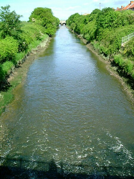
English: Highbridges new bridge, looking downstream In 1801 a new channel was begun for the River Brue where it runs through Highbridge. This is the view from the new bridge, some 150 metres south-west of the old, to the end of the cut at New Clyce Bridge, visible in the distance. Beyond the clyce (a Somerset word, in this case meaning a lock)the river is tidal. |
| Date | |
| Source | From geograph.org.uk |
| Author | Merryn |
| Camera location | | View this and other nearby images on: OpenStreetMap |
|---|
| Object location | | View this and other nearby images on: OpenStreetMap |
|---|
Licensing
[edit]
|
This image was taken from the Geograph project collection. See this photograph's page on the Geograph website for the photographer's contact details. The copyright on this image is owned by Merryn and is licensed for reuse under the Creative Commons Attribution-ShareAlike 2.0 license.
|
This file is licensed under the Creative Commons Attribution-Share Alike 2.0 Generic license.
Attribution: Merryn
- You are free:
- to share – to copy, distribute and transmit the work
- to remix – to adapt the work
- Under the following conditions:
- attribution – You must give appropriate credit, provide a link to the license, and indicate if changes were made. You may do so in any reasonable manner, but not in any way that suggests the licensor endorses you or your use.
- share alike – If you remix, transform, or build upon the material, you must distribute your contributions under the same or compatible license as the original.

_heading:292.00&language=en)
_heading:292.00&language=en)
File history
Click on a date/time to view the file as it appeared at that time.
| Date/Time | Thumbnail | Dimensions | User | Comment | |
|---|---|---|---|---|---|
| current | 21:20, 27 February 2011 | | 480 × 640 (142 KB) | GeographBot (talk | contribs) | == {{int:filedesc}} == {{Information |description={{en|1=Highbridges new bridge, looking downstream In 1801 a new channel was begun for the River Brue where it runs through Highbridge. This is the view from the new bridge, some 150 metres south-west of |
You cannot overwrite this file.
File usage on Commons
The following page uses this file: