File:Historic Trams at Heaton Park (geograph 4742068).jpg
Jump to navigation
Jump to search
No higher resolution available.
Historic_Trams_at_Heaton_Park_(geograph_4742068).jpg (640 × 481 pixels, file size: 741 KB, MIME type: image/jpeg)
Captions
Captions
Add a one-line explanation of what this file represents
Summary
[edit].jpg&action=edit§ion=1)
| Description |
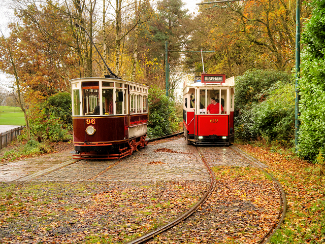
English: Historic Trams at Heaton Park. Two historic tramcars on the Heaton Park Tramway. Blackpool Vanguard tram 619 passes ex-Hull Corporation car number 96. 96 was built in 1901 by Hurst Nelson, originally as an open top double deck car. It was cut down to a single decker in 1933 and was used as a stores car and snow plough. The Manchester Transport Museum Society later bought the car, restoring it as a single deck passenger car at the Mode Wheel workshops in Salford and it has run at Heaton Park since 1988. Being totally enclosed, it is particularly welcome on wet and windy days! 619 ran in Blackpool until 1987; it was originally built in 1935 as railcoach 282, becoming 619 when the Blackpool fleet was renumbered in 1968. Following its withdrawal from service, it was transferred to the Mode Wheel workshops where it was stripped and rebuilt as a replica Blackpool and Fleetwood vanguard tram. |
| Date | Taken on 15 November 2015 |
| Source | From geograph.org.uk |
| Author | David Dixon |
| Permission (Reusing this file) |
Creative Commons Attribution Share-alike license 2.0 |
| Attribution (required by the license) | David Dixon / Historic Trams at Heaton Park / |
| Camera location | | View this and other nearby images on: OpenStreetMap |
|---|
.jpg¶ms=053.532021_N_-002.255980_E_globe:Earth_type:camera_source:geograph-osgb36(SD83130396)_heading:67.00&language=en)
| Object location | | View this and other nearby images on: OpenStreetMap |
|---|
.jpg¶ms=053.532110_N_-002.255530_E_globe:Earth_class:object_type:object_source:geograph-osgb36(SD83160397)_heading:67.00&language=en)
Licensing
[edit].jpg&action=edit§ion=2)

|
This image was taken from the Geograph project collection. See this photograph's page on the Geograph website for the photographer's contact details. The copyright on this image is owned by David Dixon and is licensed for reuse under the Creative Commons Attribution-ShareAlike 2.0 license.
|
This file is licensed under the Creative Commons Attribution-Share Alike 2.0 Generic license.
Attribution: David Dixon
- You are free:
- to share – to copy, distribute and transmit the work
- to remix – to adapt the work
- Under the following conditions:
- attribution – You must give appropriate credit, provide a link to the license, and indicate if changes were made. You may do so in any reasonable manner, but not in any way that suggests the licensor endorses you or your use.
- share alike – If you remix, transform, or build upon the material, you must distribute your contributions under the same or compatible license as the original.
File history
Click on a date/time to view the file as it appeared at that time.
| Date/Time | Thumbnail | Dimensions | User | Comment | |
|---|---|---|---|---|---|
| current | 11:18, 8 March 2019 | | 640 × 481 (741 KB) | Chris j wood (talk | contribs) | Transferred from geograph.co.uk using [https://tools.wmflabs.org/geograph2commons/ geograph2commons] |
You cannot overwrite this file.
File usage on Commons
The following 2 pages use this file:
.jpg&oldid=781218058)