File:Holy Roman Empire 1000 map-de.svg
Zur Navigation springen
Zur Suche springen

Größe der PNG-Vorschau dieser SVG-Datei: 488 × 599 pixels. Other resoluziuns: 196 × 240 pixels | 391 × 480 pixels | 626 × 768 pixels | 834 × 1.024 pixels | 1.669 × 2.048 pixels | 1.000 × 1.227 pixels.
Datoteca originala (datoteca da SVG, grondezza da basa 1.000 × 1.227 pixels, grondezza da datoteca: 458 KB)
Bildtexte
Kurzbeschreibungen
Ergänze eine einzeilige Erklärung, was diese Datei darstellt.
Resumaziun[modifitgar]
| Descripziun |
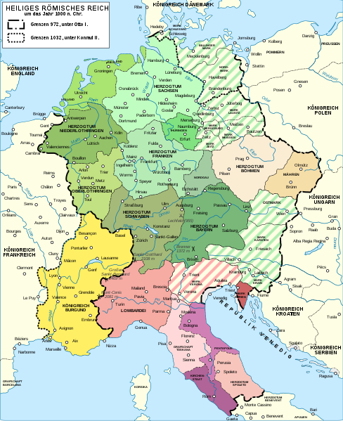
Deutsch: Karte des Heiligen Römischen Reiches um das Jahr 1000. English: Map of the Holy Roman Empire near year 1000. German version. Español: Mapa del Sacro Imperio Romano Germánico hacia el año 1000. Français : Carte du Saint-Empire romain germanique vers l'an mille (version allemand). Русский: Карта Священной Римской империи около 1000 года. |
|||
| Data | ||||
| Funtauna |
Eigenes Werk. Source :
|
|||
| Autur | ||||
| permissiun (Weiternutzung dieser Datei) |
Ich, der Urheberrechtsinhaber dieses Werkes, veröffentliche es hiermit unter der folgenden Lizenz:
This file is licensed under the Creative Commons Attribution-Share Alike 4.0 International, 3.0 Unported, 2.5 Generic, 2.0 Generic and 1.0 Generic license.
Du darfst es unter einer der obigen Lizenzen deiner Wahl verwenden. |
|||
| Andere Versionen |
Abgeleitete Werke dieser Datei: []
| |||
| Namensnennung (von der Lizenz verlangt) | © Sémhur / Wikimedia Commons / | |||
| SVG‑Erstellung |


| Kameraposition | | Dieses und weitere Bilder auf OpenStreetMap |
|---|
Istorgia da las versiuns
Clicca sin ina data/temps per vesair la versiun da lura.
| data/temp | Maletg da prevista | dimensiuns | Utilisader | commentari | |
|---|---|---|---|---|---|
| actual | 12:58, 19. avu 2016 | | 1.000 × 1.227 (458 KB) | Furfur (Discussiun | contribuziuns) | == {{int:filedesc}} == {{Information |Description={{Multilingual description |de=Karte des Heiligen Römischen Reiches um das Jahr 1000. |en= Map of the Holy Roman Empire near year 1000. Germa... |
Ti na pos betg sursvriver questa datoteca.
Utilisaziun da la datoteca
Las suandantas 15 paginas èn colliadas cun questa datoteca:
- User:JMvanDijk
- File:Holy Roman Empire 1000 map-bg.svg
- File:Holy Roman Empire 1000 map-de.png
- File:Holy Roman Empire 1000 map-de.svg
- File:Holy Roman Empire 1000 map-es.svg
- File:Holy Roman Empire 1000 map-fr.svg
- File:Holy Roman Empire 1000 map-ka.svg
- File:Holy Roman Empire 1000 map-ko.svg
- File:Holy Roman Empire 1000 map-ru.svg
- File:Holy Roman Empire 1000 map-uk.svg
- File:Holy Roman Empire 1000 map with more colours-fr.svg
- File:Holy Roman Empire 11th century map-en.svg
- File:Holy Roman Empire 11th century map-hu.svg
- File:Holy Roman Empire 11th century map-zh-hans.svg
- Template:Other versions/Holy Roman Empire 1000 map
Diever da datoteca global
Die nachfolgenden anderen Wikis verwenden diese Datei:
- Utilisaziun sin azb.wikipedia.org
- Utilisaziun sin de.wikipedia.org
- Utilisaziun sin de.wikibooks.org
- Utilisaziun sin it.wikipedia.org
- Utilisaziun sin rm.wikipedia.org
- Utilisaziun sin ro.wikipedia.org
- Utilisaziun sin ru.wikipedia.org
- Utilisaziun sin sv.wikipedia.org
- Utilisaziun sin uk.wikipedia.org