File:Hudson Bay Route Plan of the Nelson Estuary (1927).jpg
Jump to navigation
Jump to search

Size of this preview: 800 × 403 pixels. Other resolutions: 320 × 161 pixels | 640 × 322 pixels | 1,024 × 516 pixels | 1,280 × 644 pixels | 2,560 × 1,289 pixels | 7,516 × 3,784 pixels.
Original file (7,516 × 3,784 pixels, file size: 10.55 MB, MIME type: image/jpeg)
Captions
Captions
Add a one-line explanation of what this file represents
Summary
[edit]| Description |
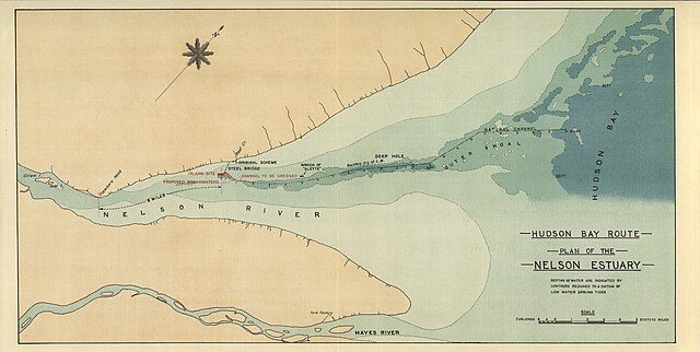
Palmer, F. Hudson Bay Route Plan of the Nelson Estuary [map]. 1:35,640. In: F. Palmer. Report on the Section of a Terminal Port for the Hudson Bay Railway. London: Harrison & Sons, Ltd., 1927. Depths of water are indicated by contours reduced to a datum of low water spring tides Report submitted to Charles A . Dunning, Minister for Railways and Canals, Government of Canada Image Courtesy of University of Manitoba : Archives & Special Collections |
| Date | |
| Source | Hudson Bay Route Plan of the Nelson Estuary (1927) |
| Author | Creator:F. Palmer via Wyman Laliberte from Edmonton, Canada |
Licensing
[edit]This file is licensed under the Creative Commons Attribution 2.0 Generic license.
- You are free:
- to share – to copy, distribute and transmit the work
- to remix – to adapt the work
- Under the following conditions:
- attribution – You must give appropriate credit, provide a link to the license, and indicate if changes were made. You may do so in any reasonable manner, but not in any way that suggests the licensor endorses you or your use.
| This image was originally posted to Flickr by Manitoba Historical Maps at https://www.flickr.com/photos/11496488@N07/3749611013. It was reviewed on 20 April 2013 by FlickreviewR and was confirmed to be licensed under the terms of the cc-by-2.0. |
| Annotations | This image is annotated: View the annotations at Commons |
.jpg)

.jpg&action=edit§ion=1)
.jpg&action=edit§ion=2)
.jpg)
File history
Click on a date/time to view the file as it appeared at that time.
| Date/Time | Thumbnail | Dimensions | User | Comment | |
|---|---|---|---|---|---|
| current | 03:50, 20 April 2013 | | 7,516 × 3,784 (10.55 MB) | Geo Swan (talk | contribs) | {{Information |Description=Palmer, F. Hudson Bay Route Plan of the Nelson Estuary [map]. 1:35,640. In: F. Palmer. Report on the Section of a Terminal Port for the Hudson Bay Railway. London: Harrison & Sons, Ltd., 1927. Depths of water are indicated ... |
You cannot overwrite this file.
File usage on Commons
The following 2 pages use this file:
_(3749611013).jpg&redirect=no)
File usage on other wikis
The following other wikis use this file:
- Usage on en.wikipedia.org
- Usage on fr.wikipedia.org
- Usage on nn.wikipedia.org
- Usage on no.wikipedia.org
- Usage on sr.wikipedia.org
.jpg&oldid=920133331)