File:Hungary in 1941 with territories annexed in 1938-1941.png
ナビゲーションに移動
検索に移動

このプレビューのサイズ: 800 × 578 ピクセル。 その他の解像度: 320 × 231 ピクセル | 640 × 462 ピクセル | 1,022 × 738 ピクセル。
元のファイル (1,022 × 738 ピクセル、ファイルサイズ: 88キロバイト、MIME タイプ: image/png)
キャプション
キャプション
このファイルの内容を1行で記述してください
| 解説 |
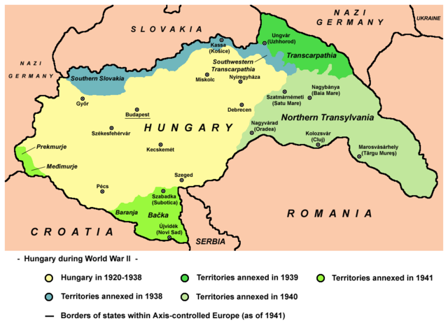
English: Map of territories annexed by Hungary in 1938-1941. |
||
| 日付 | |||
| 原典 | 投稿者自身による著作物 - derivative work; modified version of this map whose author was User:PANONIAN: File:Hungary map.png. | ||
| 作者 | Mixx321 | ||
| 許可 (ファイルの再利用) |
この作品の著作権者である私は、この作品を以下のライセンスで提供します。
|

References
[編集]
- The Times History of Europe, Times Books, London, 2002
- Richard Overy, The Times History of the 20th Century, Times Books, London, 2004.
- Peter Rokai - Zoltan Đere - Tibor Pal - Aleksandar Kasaš, Istorija Mađara, Beograd, 2002.
- http://terkepek.adatbank.transindex.ro/kepek/netre/224.gif
- http://www.hunmagyar.org/tor/terkep.jpg
- http://www.map.hu/galeria/orig/1426_hu_in_maps_fig_12_states_1648-2009.jpg アーカイブされたコピー at the Wayback Machine
- http://magyar.files.wordpress.com/2006/07/11399032041.JPG?w=440&h=343
- http://crowland.uw.hu/images/csata/delvidek_02.jpg アーカイブされたコピー at the Wayback Machine
- http://www.conflicts.rem33.com/images/Ungarn/hunhist_V_files/image004.jpg
Other versions
[編集]
ファイルの履歴
過去の版のファイルを表示するには、その版の日時をクリックしてください。
| 日付と時刻 | サムネイル | 寸法 | 利用者 | コメント | |
|---|---|---|---|---|---|
| 現在の版 | 2014年4月14日 (月) 19:35 | | 1,022 × 738 (88キロバイト) | PANONIAN (トーク | 投稿記録) | more regional names + I will elaborate poland and ukraine issues on talk page |
| 2014年2月26日 (水) 20:23 |  | 1,022 × 738 (80キロバイト) | Poeticbent (トーク | 投稿記録) | more legend, added missing historical names and dates | |
| 2014年2月17日 (月) 17:38 |  | 1,022 × 738 (74キロバイト) | PANONIAN (トーク | 投稿記録) | corrected borders and improved aesthetics | |
| 2010年9月1日 (水) 15:52 |  | 1,023 × 738 (60キロバイト) | Mixx321 (トーク | 投稿記録) | {{Information |Description={{en|1=Map of territories added to Hungary 1938-1947}} |Source={{own}} |Author=Mixx321 |Date=2010.IX.1 |Permission={{GFDL-self}} |other_versions= }} File:Hungary_map.png [[Category:History of Hungary betwee |
このファイルは上書きできません。
ファイルの使用状況
以下の 2 ページがこのファイルを使用しています:
グローバルなファイル使用状況
以下に挙げる他のウィキがこの画像を使っています:
- be.wikipedia.org での使用状況
- bs.wikipedia.org での使用状況
- en.wikipedia.org での使用状況
- es.wikipedia.org での使用状況
- et.wikipedia.org での使用状況
- fi.wikipedia.org での使用状況
- fr.wikipedia.org での使用状況
- he.wikipedia.org での使用状況
- id.wikipedia.org での使用状況
- no.wikipedia.org での使用状況
- pl.wikipedia.org での使用状況
- pt.wikipedia.org での使用状況
- sr.wikipedia.org での使用状況
- th.wikipedia.org での使用状況
- uk.wikipedia.org での使用状況