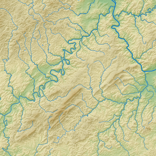
File:Hunsrück (Relief und Gewässer) - Deutsche Mittelgebirge, Serie A-de.png

Original file (2,100 × 2,100 pixels, file size: 6.16 MB, MIME type: image/png)
Captions
Captions
Summary[edit]
| Description |
English: Topographical relief of the Hunsrück (with water bodies)
Deutsch: Relief des Hunsrück (mit Gewässern) |
||||||||||||||||||
| Date | |||||||||||||||||||
| Source |
Own work using: |
||||||||||||||||||
| Author | Thoroe | ||||||||||||||||||
| Other versions |
 Topographic maps of German low mountain ranges (A series)
This map series aims to show the major low mountain ranges of Germany in a uniform design. All maps are created on the same scale, and the background reliefs base upon the same color scheme. The reliefs are also available as separate files. You can find the making-of one of the maps in the German language Wikipedia (German only).
|
||||||||||||||||||


_-_Deutsche_Mittelgebirge,_Serie_A-de.png)
_-_Deutsche_Mittelgebirge,_Serie_A-de.png)
_-_Deutsche_Mittelgebirge,_Serie_A-de.png)
_-_Deutsche_Mittelgebirge,_Serie_A-de.png)
_-_Deutsche_Mittelgebirge,_Serie_A-de.png)
_-_Deutsche_Mittelgebirge,_Serie_A-de.png)
_-_Deutsche_Mittelgebirge,_Serie_A-de.png)
_-_Deutsche_Mittelgebirge,_Serie_A-de.png)
_-_Deutsche_Mittelgebirge,_Serie_A-de.png)
_-_Deutsche_Mittelgebirge,_Serie_A-de.png)
_-_Deutsche_Mittelgebirge,_Serie_A-de.png)
_-_Deutsche_Mittelgebirge,_Serie_A-de.png)
_-_Deutsche_Mittelgebirge,_Serie_A-de.png)
_-_Deutsche_Mittelgebirge,_Serie_A-de.png)
_-_Deutsche_Mittelgebirge,_Serie_A-de.png)
_-_Deutsche_Mittelgebirge,_Serie_A-de.png)
_-_Deutsche_Mittelgebirge,_Serie_A-de.png)
_-_Deutsche_Mittelgebirge,_Serie_A-de.png)
_-_Deutsche_Mittelgebirge,_Serie_A-de.png)
_-_Deutsche_Mittelgebirge,_Serie_A-de.png)
_-_Deutsche_Mittelgebirge,_Serie_A-de.png)
_-_Deutsche_Mittelgebirge,_Serie_A-de.png)
_-_Deutsche_Mittelgebirge,_Serie_A-de.png)
_-_Deutsche_Mittelgebirge,_Serie_A-de.png)
_-_Deutsche_Mittelgebirge,_Serie_A-de.png)
_-_Deutsche_Mittelgebirge,_Serie_A-de.png)
_-_Deutsche_Mittelgebirge,_Serie_A-de.png)
_-_Deutsche_Mittelgebirge,_Serie_A-de.png)
_-_Deutsche_Mittelgebirge,_Serie_A-de.png)
_-_Deutsche_Mittelgebirge,_Serie_A-de.png)
_-_Deutsche_Mittelgebirge,_Serie_A-de.png)
_-_Deutsche_Mittelgebirge,_Serie_A-de.png)
_-_Deutsche_Mittelgebirge,_Serie_A-de.png&action=edit§ion=1)
| This work contains information from OpenStreetMap, which is made available under the Open Database License (ODbL).
The ODbL does not require any particular license for maps produced from ODbL data. Prior to 1 August 2020, map tiles produced by the OpenStreetMap Foundation were licensed under the CC-BY-SA-2.0 license. Maps produced by other people may be subject to other licences. |

|
This map has been made or improved in the German Kartenwerkstatt (Map Lab). You can propose maps to improve as well.
|
Licensing[edit]
_-_Deutsche_Mittelgebirge,_Serie_A-de.png&action=edit§ion=2)
- You are free:
- to share – to copy, distribute and transmit the work
- to remix – to adapt the work
- Under the following conditions:
- attribution – You must give appropriate credit, provide a link to the license, and indicate if changes were made. You may do so in any reasonable manner, but not in any way that suggests the licensor endorses you or your use.
- share alike – If you remix, transform, or build upon the material, you must distribute your contributions under the same or compatible license as the original.
File history
Click on a date/time to view the file as it appeared at that time.
| Date/Time | Thumbnail | Dimensions | User | Comment | |
|---|---|---|---|---|---|
| current | 11:26, 13 May 2017 | | 2,100 × 2,100 (6.16 MB) | Thoroe (talk | contribs) | {{Information |Description ={{en|1=Topographical relief of the Hunsrück (with water bodies)}} {{de|1=Relief des Hunsrück (mit Gewässern)}} |Source ={{Own using}} *[http://gmt.soest.hawaii.edu Generic Ma... |
You cannot overwrite this file.
File usage on Commons
The following 50 pages use this file:
- File:Bayerischer Wald (Relief) - Deutsche Mittelgebirge, Serie A-de.png
- File:Bayerischer Wald (Relief und Gewässer) - Deutsche Mittelgebirge, Serie A-de.png
- File:Bayerischer Wald - Deutsche Mittelgebirge, Serie A-de.png
- File:Deutsche Mittelgebirge, Serie A - Abdeckung.svg
- File:Eifel (Relief) - Deutsche Mittelgebirge, Serie A-de.png
- File:Eifel (Relief und Gewässer) - Deutsche Mittelgebirge, Serie A-de.png
- File:Eifel - Deutsche Mittelgebirge, Serie A-de.png
- File:Harz (Relief) - Deutsche Mittelgebirge, Serie A-de.png
- File:Harz (Relief und Gewässer) - Deutsche Mittelgebirge, Serie A-de.png
- File:Harz - Deutsche Mittelgebirge, Serie A-de.png
- File:Hunsrück (Relief) - Deutsche Mittelgebirge, Serie A-de.png
- File:Hunsrück (Relief und Gewässer) - Deutsche Mittelgebirge, Serie A-de.png
- File:Hunsrück - Deutsche Mittelgebirge, Serie A-de.png
- File:Oberpfälzer Wald (Relief) - Deutsche Mittelgebirge, Serie A-de.png
- File:Oberpfälzer Wald (Relief und Gewässer) - Deutsche Mittelgebirge, Serie A-de.png
- File:Oberpfälzer Wald - Deutsche Mittelgebirge, Serie A-de.png
- File:Odenwald (Relief) - Deutsche Mittelgebirge, Serie A-de.png
- File:Odenwald (Relief und Gewässer) - Deutsche Mittelgebirge, Serie A-de.png
- File:Odenwald - Deutsche Mittelgebirge, Serie A-de.png
- File:Rhön (Relief) - Deutsche Mittelgebirge, Serie A-de.png
- File:Rhön (Relief und Gewässer) - Deutsche Mittelgebirge, Serie A-de.png
- File:Rhön - Deutsche Mittelgebirge, Serie A-de.png
- File:Rothaargebirge (Relief) - Deutsche Mittelgebirge, Serie A-de.png
- File:Rothaargebirge (Relief und Gewässer) - Deutsche Mittelgebirge, Serie A-de.png
- File:Rothaargebirge - Deutsche Mittelgebirge, Serie A-de.png
- File:Schwarzwald (Relief) - Deutsche Mittelgebirge, Serie A-de.png
- File:Schwarzwald (Relief und Gewässer) - Deutsche Mittelgebirge, Serie A-de.png
- File:Schwarzwald - Deutsche Mittelgebirge, Serie A-de.png
- File:Schwäbische Alb (Relief) - Deutsche Mittelgebirge, Serie A-de.png
- File:Schwäbische Alb (Relief und Gewässer) - Deutsche Mittelgebirge, Serie A-de.png
- File:Schwäbische Alb - Deutsche Mittelgebirge, Serie A-de.png
- File:Spessart (Relief) - Deutsche Mittelgebirge, Serie A-de.png
- File:Spessart (Relief und Gewässer) - Deutsche Mittelgebirge, Serie A-de.png
- File:Spessart - Deutsche Mittelgebirge, Serie A-de.png
- File:Taunus (Relief) - Deutsche Mittelgebirge, Serie A-de.png
- File:Taunus (Relief und Gewässer) - Deutsche Mittelgebirge, Serie A-de.png
- File:Taunus - Deutsche Mittelgebirge, Serie A-de.png
- File:Teutoburger Wald (Relief) - Deutsche Mittelgebirge, Serie A-de.png
- File:Teutoburger Wald (Relief und Gewässer) - Deutsche Mittelgebirge, Serie A-de.png
- File:Teutoburger Wald - Deutsche Mittelgebirge, Serie A-de.png
- File:Thüringer Wald (Relief) - Deutsche Mittelgebirge, Serie A-de.png
- File:Thüringer Wald (Relief und Gewässer) - Deutsche Mittelgebirge, Serie A-de.png
- File:Thüringer Wald - Deutsche Mittelgebirge, Serie A-de.png
- File:Vogelsberg (Relief) - Deutsche Mittelgebirge, Serie A-de.png
- File:Vogelsberg (Relief und Gewässer) - Deutsche Mittelgebirge, Serie A-de.png
- File:Vogelsberg - Deutsche Mittelgebirge, Serie A-de.png
- File:Westerwald (Relief) - Deutsche Mittelgebirge, Serie A-de.png
- File:Westerwald (Relief und Gewässer) - Deutsche Mittelgebirge, Serie A-de.png
- File:Westerwald - Deutsche Mittelgebirge, Serie A-de.png
- Template:Topographic maps of German low mountain ranges (Mittelgebirge), A series
_-_Deutsche_Mittelgebirge,_Serie_A-de.png&oldid=455158565)