File:Hurricane Sandy overflight assesment DVIDS1123971.jpg
![File:Hurricane Sandy overflight assesment DVIDS1123971.jpg](https://upload.wikimedia.org/wikipedia/commons/thumb/0/0f/Hurricane_Sandy_overflight_assesment_DVIDS1123971.jpg/800px-Hurricane_Sandy_overflight_assesment_DVIDS1123971.jpg?20150318212825)
Original file (4,608 × 3,456 pixels, file size: 5.41 MB, MIME type: image/jpeg)
Captions
Captions
Summary
[edit]DescriptionHurricane Sandy overflight assesment DVIDS1123971.jpg |
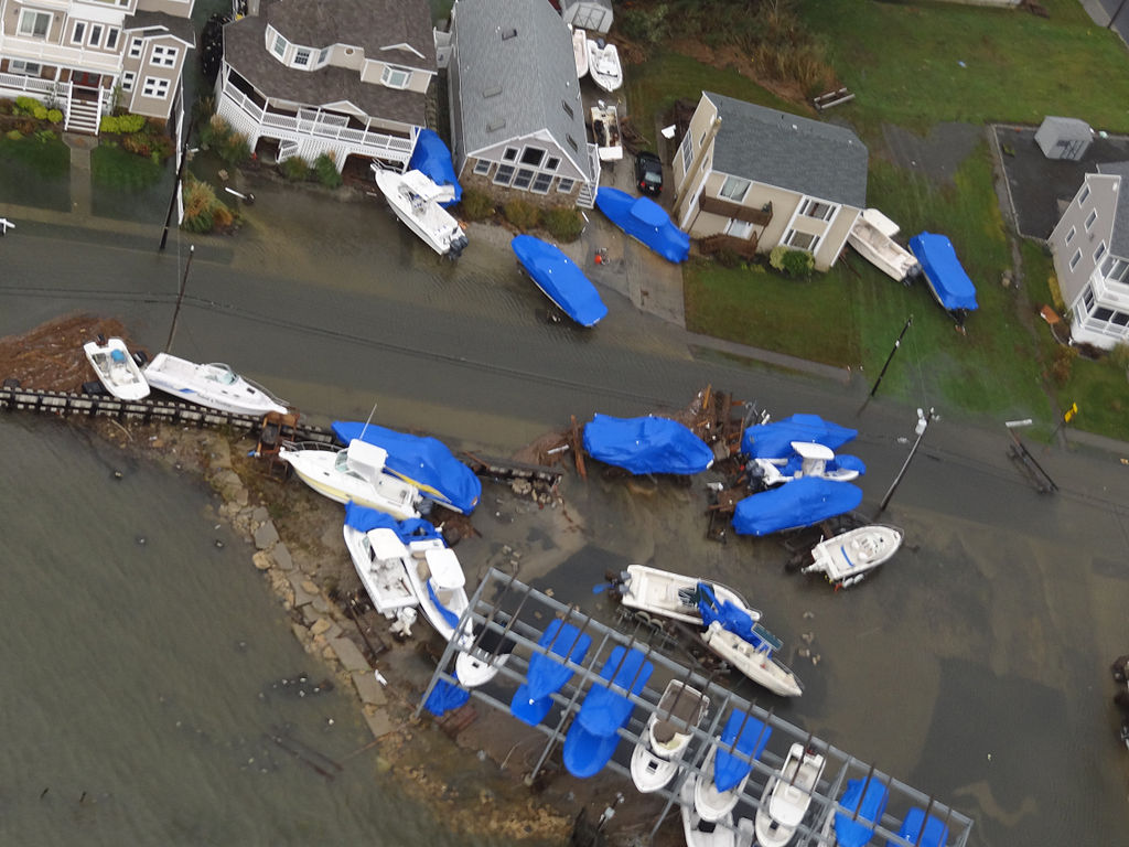
English: Boats are displaced in Brigantine, N.J., Oct. 30, 2012, after Hurricane Sandy made landfall on the southern New Jersey coastline, Oct. 29, 2012. The photo was taken by a Coast Guard crewmember aboard an MH-65 Dolphin helicopter from Coast Guard Air Station Atlantic City during a flooding assessment overflight. U.S. Coast Guard photo. |
Date | Taken on 30 October 2012 |
Source | https://www.dvidshub.net/image/1123971 |
Author |
This file is lacking author information.
|
Location InfoField | BRIGANTINE, NJ, US |
Posted InfoField | 13 December 2013, 02:26 |
DVIDS ID InfoField | 1123971 |
Archive link InfoField | archive copy at the Wayback Machine |
Licensing
[edit]Public domainPublic domainfalsefalse |
![]() |
This image or file is a work of a United States Coast Guard service personnel or employee, taken or made as part of that person's official duties. As a work of the U.S. federal government, the image or file is in the public domain (17 U.S.C. § 101 and § 105, USCG main privacy policy and specific privacy policy for its imagery server).
العربية ∙ English ∙ italiano ∙ 日本語 ∙ македонски ∙ മലയാളം ∙ русский ∙ sicilianu ∙ Türkçe ∙ українська ∙ Tiếng Việt ∙ +/− |
![]() |
File history
Click on a date/time to view the file as it appeared at that time.
Date/Time | Thumbnail | Dimensions | User | Comment | |
---|---|---|---|---|---|
current | 21:28, 18 March 2015 | ![]() | 4,608 × 3,456 (5.41 MB) | Fæ (talk | contribs) | == {{int:filedesc}} == {{milim | description = {{en|1=Boats are displaced in Brigantine, N.J., Oct. 30, 2012, after Hurricane Sandy made landfall on the southern New Jersey coastline, Oct. 29, 2012. The photo was taken by a Coast Guard crewmember aboar... |
You cannot overwrite this file.
File usage on Commons
There are no pages that use this file.
Metadata
This file contains additional information such as Exif metadata which may have been added by the digital camera, scanner, or software program used to create or digitize it. If the file has been modified from its original state, some details such as the timestamp may not fully reflect those of the original file. The timestamp is only as accurate as the clock in the camera, and it may be completely wrong.
Image title |
|
---|---|
Camera manufacturer | SONY |
Camera model | DSC-HX100V |
Author | U.S. Coast Guard photo. |
Exposure time | 1/100 sec (0.01) |
F-number | f/4 |
ISO speed rating | 125 |
Date and time of data generation | 06:56, 30 October 2012 |
Lens focal length | 12.32 mm |
Short title |
|
Headline | Hurricane Sandy overflight assesment |
City shown | Brigantine |
Credit/Provider | U.S. Coast Guard |
Source | Digital |
Copyright holder | Public Domain |
Width | 4,608 px |
Height | 3,456 px |
Bits per component |
|
Pixel composition | RGB |
Orientation | Normal |
Number of components | 3 |
Horizontal resolution | 72 dpi |
Vertical resolution | 72 dpi |
Software used | Adobe Photoshop CS5.1 Macintosh |
File change date and time | 13:17, 30 October 2012 |
Y and C positioning | Co-sited |
Exposure Program | Normal program |
Exif version | 2.3 |
Date and time of digitizing | 06:56, 30 October 2012 |
Meaning of each component |
|
Image compression mode | 2 |
APEX shutter speed | 6.643856 |
APEX aperture | 4 |
APEX brightness | 5.4703125 |
APEX exposure bias | 0 |
Maximum land aperture | 3 APEX (f/2.83) |
Metering mode | Pattern |
Light source | Unknown |
Flash | Flash did not fire, compulsory flash suppression |
Supported Flashpix version | 1 |
Color space | sRGB |
File source | Digital still camera |
Scene type | A directly photographed image |
Custom image processing | Normal process |
Exposure mode | Auto exposure |
White balance | Auto white balance |
Digital zoom ratio | 1 |
Scene capture type | Standard |
Contrast | Normal |
Saturation | Normal |
Sharpness | Normal |
Receiver status | Measurement interoperability |
Reference for direction of image | Magnetic direction |
Direction of image | 293.75 |
Geodetic survey data used | WGS-84 |
GPS differential correction | 0 |
GPS tag version | 0.0.3.2 |
Lens used | 4.8-144.0 mm f/2.8-5.6 |
Date metadata was last modified | 09:17, 30 October 2012 |
Unique ID of original document | xmp.did:04801174072068119457C97694262E8A |
Keywords |
|
Province or state shown | NJ |
Code for country shown | US |
Special instructions | Released
DVIDS Hub U.S. Coast Guard District 5 dvidshub@dvidshub.net via DVIDS |
Original transmission location code | U.S. Coast Guard |
Country shown | United States |