File:IJsselmeer satellite.jpg
跳至導覽
跳至搜尋
預覽大小:565 × 599 像素。 其他解析度:226 × 240 像素 | 453 × 480 像素 | 893 × 947 像素。
原始檔案 (893 × 947 像素,檔案大小:268 KB,MIME 類型:image/jpeg)
說明
說明
添加單行說明來描述出檔案所代表的內容
摘要
[編輯]
| 描述 |
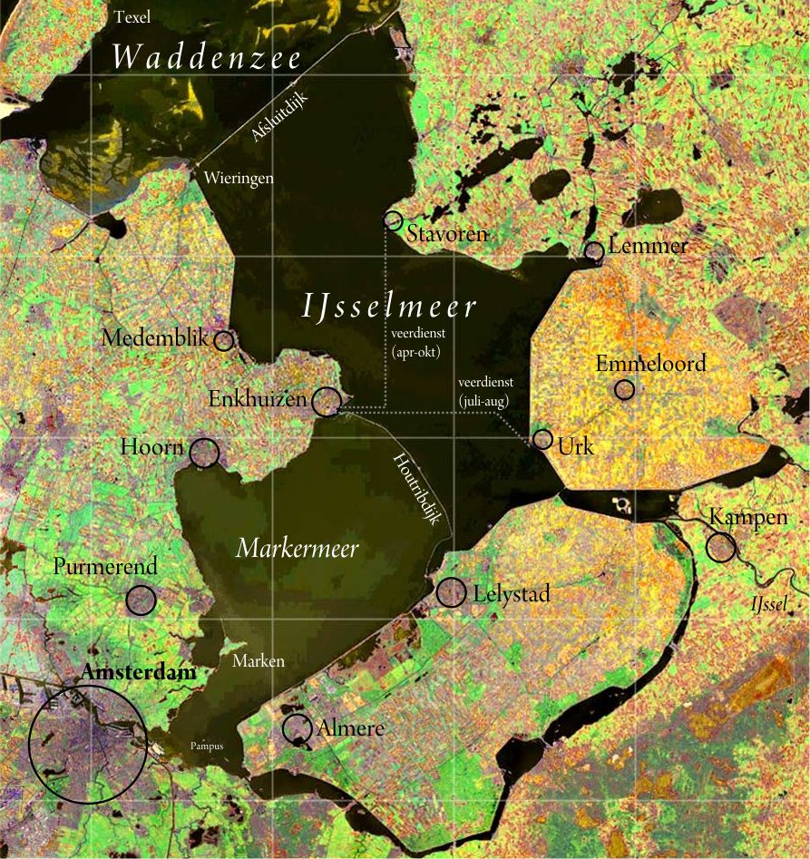
Nederlands: IJsselmeer. Satellietopname: Nasa Visible Earth Samenstelling foto, kleur- en schaalcorrectie, kaartopmaak: Ed Stevenhagen
English: IJsselmeer (also known as Lake IJssel or Lake Yssel) Satellite photo from Nasa Visible Earthvcomposition photograph, colours and scale correction, card layout done by Ed Stevenhagen |
| 日期 | Commons upload by Siebrand 12:09, 23 May 2006 (UTC) |
| 來源 |
NASA Visible Earth. Originally on Wikipedia from nl.wikipedia; description page is (was) here
|
| 作者 | User Ed Stevenhagen on nl.wikipedia |
| 授權許可 (重用此檔案) |
PD-NASA |
授權條款
[編輯]
| 本作品由NASA創作,屬於公有領域。根據NASA的版權政策:“NASA的創作除非另有聲明否則不受版權保護。”(參見:Template:PD-USGov/zh,NASA版權政策或JPL圖像使用政策) | ||
 |
警告:
|
檔案歷史
點選日期/時間以檢視該時間的檔案版本。
| 日期/時間 | 縮圖 | 尺寸 | 使用者 | 備註 | |
|---|---|---|---|---|---|
| 目前 | 2012年12月6日 (四) 12:00 | | 893 × 947(268 KB) | Classical geographer(留言 | 貢獻) | +labels |
| 2008年8月21日 (四) 01:15 |  | 893 × 947(498 KB) | Cropbot(留言 | 貢獻) | upload cropped version, operated by User:Rfsjim. Summary: Rfsjim cropped caption using Cropbot | |
| 2008年5月20日 (二) 16:58 |  | 988 × 1,214(652 KB) | Chech Explorer(留言 | 貢獻) | Without borders | |
| 2006年5月23日 (二) 12:09 |  | 1,000 × 1,225(261 KB) | Siebrand(留言 | 貢獻) | {{Information| |Description= {{nl|IJsselmeer. Satellietopname: nl:Nasa Visible Earth Samenstelling foto, kleur- en schaalcorrectie, kaartopmaak: Ed Stevenhagen}} Free to use as long as credits are given to Nasa Vis |
無法覆蓋此檔案。
檔案用途
沒有使用此檔案的頁面。
全域檔案使用狀況
以下其他 wiki 使用了這個檔案:
- ar.wikipedia.org 的使用狀況
- be.wikipedia.org 的使用狀況
- cs.wikipedia.org 的使用狀況
- cv.wikipedia.org 的使用狀況
- de.wikivoyage.org 的使用狀況
- en.wikipedia.org 的使用狀況
- eo.wikipedia.org 的使用狀況
- fy.wikipedia.org 的使用狀況
- ko.wikipedia.org 的使用狀況
- nds-nl.wikipedia.org 的使用狀況
- nl.wikipedia.org 的使用狀況
- ro.wikipedia.org 的使用狀況
- ru.wikipedia.org 的使用狀況
- tr.wikipedia.org 的使用狀況
- zh.wikipedia.org 的使用狀況