File:Iceland Mid-Atlantic Ridge map mk.svg
Jump to navigation
Jump to search

Size of this PNG preview of this SVG file: 376 × 390 pixels. Other resolutions: 231 × 240 pixels | 463 × 480 pixels | 740 × 768 pixels | 987 × 1,024 pixels | 1,974 × 2,048 pixels.
Original file (SVG file, nominally 376 × 390 pixels, file size: 134 KB)
Captions
Captions
Add a one-line explanation of what this file represents
Summary[edit]
| Description |
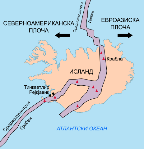
Македонски: Средноатлантскиот Гребен како минува низ Исланд и ги двои Северноамериканската и Евроазиската Плоча.
English: Map in Macedonian showing the Mid-Atlantic Ridge splitting Iceland and separating the North American and Eurasian Plates |
| Date | |
| Source | File:Iceland Mid-Atlantic Ridge map.svg |
| Author |
original by Beao derivative by B. Jankuloski |
| Other versions |
|


Licensing[edit]
| This file is made available under the Creative Commons CC0 1.0 Universal Public Domain Dedication. | |
| The person who associated a work with this deed has dedicated the work to the public domain by waiving all of their rights to the work worldwide under copyright law, including all related and neighboring rights, to the extent allowed by law. You can copy, modify, distribute and perform the work, even for commercial purposes, all without asking permission.
|
File history
Click on a date/time to view the file as it appeared at that time.
| Date/Time | Thumbnail | Dimensions | User | Comment | |
|---|---|---|---|---|---|
| current | 00:40, 9 January 2021 | | 376 × 390 (134 KB) | Bjankuloski06 (talk | contribs) | Uploaded a work by original by Beao<br>derivative by B. Jankuloski from File:Iceland Mid-Atlantic Ridge map.svg with UploadWizard |
You cannot overwrite this file.
File usage on Commons
The following 2 pages use this file:
File usage on other wikis
The following other wikis use this file:
- Usage on mk.wikipedia.org