File:Inglesham – east end of the Thames and Severn Canal.jpg
Jump to navigation
Jump to search

Size of this preview: 800 × 532 pixels. Other resolutions: 320 × 213 pixels | 640 × 426 pixels | 1,024 × 681 pixels | 1,280 × 851 pixels | 1,600 × 1,064 pixels.
Original file (1,600 × 1,064 pixels, file size: 388 KB, MIME type: image/jpeg)
Captions
Captions
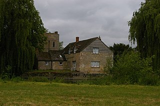
Inglesham round house and adjacent buildings
Summary[edit]
| Description |
English: The Thames flows from left to right across the picture, whilst the disused Thames and Severn Canal runs behind the buildings (through the remains of Inglesham Lock) and into the river behind the willow on the extreme right. Visible behind the riverside house is the lock-keeper's cottage, one of the Thames and Severn's extremely characteristic two-storey round towers (a few others survive along the route). |
| Date | |
| Source | https://www.geograph.org.uk/photo/2439368 |
| Author | Christopher Hilton |
| Attribution (required by the license) | Christopher Hilton / Inglesham: east end of the Thames and Severn Canal / |
| Camera location | | View this and other nearby images on: OpenStreetMap |
|---|
_heading:270.00&language=en)
| Object location | | View this and other nearby images on: OpenStreetMap |
|---|
_heading:270.00&language=en)
Licensing[edit]

|
This image was taken from the Geograph project collection. See this photograph's page on the Geograph website for the photographer's contact details. The copyright on this image is owned by Christopher Hilton and is licensed for reuse under the Creative Commons Attribution-ShareAlike 2.0 license.
|
This file is licensed under the Creative Commons Attribution-Share Alike 2.0 Generic license.
Attribution: Christopher Hilton
- You are free:
- to share – to copy, distribute and transmit the work
- to remix – to adapt the work
- Under the following conditions:
- attribution – You must give appropriate credit, provide a link to the license, and indicate if changes were made. You may do so in any reasonable manner, but not in any way that suggests the licensor endorses you or your use.
- share alike – If you remix, transform, or build upon the material, you must distribute your contributions under the same or compatible license as the original.
File history
Click on a date/time to view the file as it appeared at that time.
| Date/Time | Thumbnail | Dimensions | User | Comment | |
|---|---|---|---|---|---|
| current | 12:27, 15 June 2021 | | 1,600 × 1,064 (388 KB) | Bjh21 (talk | contribs) | Higher-resolution version from Geograph |
| 14:30, 14 June 2021 |  | 1,024 × 681 (164 KB) | MIDI (talk | contribs) | Uploaded a work by Christopher Hilton from https://www.geograph.org.uk/photo/2439368 with UploadWizard |
You cannot overwrite this file.
File usage on Commons
There are no pages that use this file.
File usage on other wikis
The following other wikis use this file:
- Usage on en.wikipedia.org