File:Isles of Scilly UK location map.svg
Aller à la navigation
Aller à la recherche

Taille de cet aperçu PNG pour ce fichier SVG : 677 × 600 pixels. Autres résolutions : 271 × 240 pixels | 542 × 480 pixels | 867 × 768 pixels | 1 156 × 1 024 pixels | 2 312 × 2 048 pixels | 1 340 × 1 187 pixels.
Fichier d’origine (Fichier SVG, nominalement de 1 340 × 1 187 pixels, taille : 558 kio)
Légendes
Légendes
Ajoutez en une ligne la description de ce que représente ce fichier
| Description |
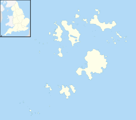
Blank map of the Isles of Scilly, UK with districts shown. Equirectangular map projection on WGS 84 datum, with N/S stretched 150% Geographic limits:
|
| Date | |
| Source | Ordnance Survey OpenData. Most data from Boundary-Line product. Lake data from Meridian 2 product. Inset derived from England location map.svg by Spischot. |
| Auteur | Nilfanion, created using Ordnance Survey data |
| Autorisation (Réutilisation de ce fichier) |
Ce fichier est disponible selon les termes de la licence Creative Commons Attribution – Partage dans les Mêmes Conditions 3.0 (non transposée). Attribution: Contains Ordnance Survey data © Crown copyright and database right
|
Historique du fichier
Cliquer sur une date et heure pour voir le fichier tel qu'il était à ce moment-là.
| Date et heure | Vignette | Dimensions | Utilisateur | Commentaire | |
|---|---|---|---|---|---|
| actuel | 26 septembre 2010 à 20:39 | | 1 340 × 1 187 (558 kio) | Nilfanion (d | contributions) | {{Information |Description=Blank map of the Isles of Scilly, UK with districts shown. Equirectangular map projection on WGS 84 datum, with N/S stretched 150% Geographic limits: *West: 6.45W *East: 6.23W *North: 49.99N *South: 49.86 |
Vous ne pouvez pas remplacer ce fichier.
Utilisations locales du fichier
Les 6 pages suivantes utilisent ce fichier :
Utilisations du fichier sur d’autres wikis
Les autres wikis suivants utilisent ce fichier :
- Utilisation sur af.wikipedia.org
- Utilisation sur ar.wikipedia.org
- Utilisation sur arz.wikipedia.org
- Utilisation sur ast.wikipedia.org
- Utilisation sur ca.wikipedia.org
- Utilisation sur ceb.wikipedia.org
- Utilisation sur de.wikipedia.org
- Bishop Rock
- Samson (Insel)
- Annet (Scilly-Inseln)
- St Mary’s (Scilly-Inseln)
- St Mary’s Airport
- Tresco
- Hugh Town
- St. Martin’s
- Great Ganilly
- Teän
- St. Helen’s
- Zantman’s Rock
- Crim Rocks
- Round Island (Scilly-Inseln)
- Rosevear
- Bryher
- Gweal
- Gugh
- Vorlage:Positionskarte England Scilly-Inseln
- St. Agnes (Scilly-Inseln)
- White Island (Scilly-Inseln)
- Norrard Rocks
- Western Rocks (Scilly-Inseln)
- Eastern Isles
- Tresco Heliport
- Utilisation sur el.wikipedia.org
- Utilisation sur en.wikipedia.org
- Samson, Isles of Scilly
- Tresco, Isles of Scilly
- St Mary's, Isles of Scilly
- Hugh Town
- HMS Colossus (1787)
- Bant's Carn
- Porth Hellick Down
- Pednathise Head
- St Agnes, Isles of Scilly
- Bryher
- St Martin's, Isles of Scilly
- Zantman's Rock
- MV Cita
- Minnehaha (cargo ship)
- SS Thames
- Annet, Isles of Scilly
- Crim Rocks
Voir davantage sur l’utilisation globale de ce fichier.