File:Israel - Location Map (2012) - ISR - UNOCHA.svg

原始檔案 (SVG 檔案,表面大小:250 × 250 像素,檔案大小:141 KB)
說明
說明
摘要
[編輯]| 描述 |
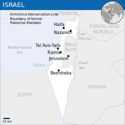
English: Locator map of Israel. العربية: خريطة إسرائيل. |
| 日期 | |
| 來源 |
English: [1], OCHA, UNCS |
| 作者 | |
| 其他版本 |
|
| SVG開發 |
_-_ISR_-_UNOCHA-ar.svg)
_-_ISR_-_UNOCHA-ur.svg)
_-_ISR_-_UNOCHA-zh.svg)
_-_ISR_-_UNOCHA-id.svg)
_-_ISR_-_UNOCHA.svg&action=edit§ion=1)
授權條款
[編輯]_-_ISR_-_UNOCHA.svg&action=edit§ion=2)
- 您可以自由:
- 分享 – 複製、發佈和傳播本作品
- 重新修改 – 創作演繹作品
- 惟需遵照下列條件:
- 姓名標示 – 您必須指名出正確的製作者,和提供授權條款的連結,以及表示是否有對內容上做出變更。您可以用任何合理的方式來行動,但不得以任何方式表明授權條款是對您許可或是由您所使用。
 This map is part of a collection of 216 free country maps, created by the UN Office for the Coordination of Humanitarian Affairs (OCHA), to be used in print, web or broadcast products.
The ReliefWeb Location Maps released here are maps that highlight a country, its capital, major populated places and the surrounding regions. Attribution Requirements
Using the map without modifications: ensure that the sources and the disclaimer are below the map. Credit as follows: "Credit: OCHA". For use with alteration: remove the OCHA logo and disclaimer following any modification to the map, but keep the data sources as mentioned below the map. Credit the modified map as follows: "Based on OCHA map". You are responsible for the content of your map. We are keen to receive your feedback and hear how you used OCHA's maps. We would be grateful if you would notify us by e-mail and share your work with us. UN Disclaimer
The designations employed and the presentation of material of this map do not imply the expression of any opinion whatsoever on the part of the Secretariat of the United Nations concerning the legal status of any country, territory, city or area or of its authorities or concerning the delimitation of its frontiers or boundaries. |

|
一旦在圖像本身中可見的文本信息(例如時間戳)已移動到圖像元數據和/或圖像描述頁面。 這使圖像更易於重用且更不依賴語言,並使文本更易於處理和搜索。共享資源勸阻在圖像中放置可見的文本信息。共享資源接受的所有許可證都允許將這種類型的修改作為衍生作品進行。
如果屬性信息被刪除並且圖像不是公共領域,請將此標記替換為{{Attribution metadata from licensed image}}。
|
檔案歷史
點選日期/時間以檢視該時間的檔案版本。
| 日期/時間 | 縮圖 | 尺寸 | 使用者 | 備註 | |
|---|---|---|---|---|---|
| 目前 | 2023年10月8日 (日) 08:26 | | 250 × 250(141 KB) | Trần Nguyễn Minh Huy(留言 | 貢獻) | File uploaded using svgtranslate tool (https://svgtranslate.toolforge.org/). Added translation for vi. |
| 2022年7月27日 (三) 06:39 |  | 250 × 250(140 KB) | Enkhsaihan2005(留言 | 貢獻) | File uploaded using svgtranslate tool (https://svgtranslate.toolforge.org/). Added translation for mn. | |
| 2022年7月27日 (三) 06:38 |  | 250 × 250(139 KB) | Enkhsaihan2005(留言 | 貢獻) | File uploaded using svgtranslate tool (https://svgtranslate.toolforge.org/). Added translation for mn. | |
| 2022年3月28日 (一) 01:48 |  | 250 × 250(136 KB) | Nyilvoskt(留言 | 貢獻) | File uploaded using svgtranslate tool (https://svgtranslate.toolforge.org/). Added translation for id. | |
| 2022年2月17日 (四) 15:21 |  | 250 × 250(134 KB) | Kurmanbek(留言 | 貢獻) | File uploaded using svgtranslate tool (https://svgtranslate.toolforge.org/). Added translation for tr. | |
| 2016年2月17日 (三) 22:27 |  | 250 × 250(130 KB) | Wereldburger758(留言 | 貢獻) | Resized page to drawing. Removal watermark. Validation of image. | |
| 2014年8月19日 (二) 03:21 |  | 250 × 250(185 KB) | Pharos(留言 | 貢獻) | == {{int:filedesc}} == {{Information |description={{en|1=Locator map of Chile.}} |date=2013 |source={{en|1=[http://reliefweb.int/map/chile/chile-location-map-2013 Chile Locator Map (ReliefWeb)]}} |author={{en|1=[[w:en:United Nations Offi... |
無法覆蓋此檔案。
檔案用途
下列7個頁面有用到此檔案:
- User:Chinggis6/Favorites
- User:Chumwa/OgreBot/Potential transport maps/2016 February 10-19
- User:Geagea/Israel/2016 February 17
- File:Israel - Location Map (2012) - ISR - UNOCHA-ar.svg
- File:Israel - Location Map (2012) - ISR - UNOCHA-id.svg
- File:Israel - Location Map (2012) - ISR - UNOCHA-ur.svg
- File:Israel - Location Map (2012) - ISR - UNOCHA-zh.svg
全域檔案使用狀況
以下其他 wiki 使用了這個檔案:
- ar.wikipedia.org 的使用狀況
- az.wikipedia.org 的使用狀況
- ban.wikipedia.org 的使用狀況
- bcl.wikipedia.org 的使用狀況
- bh.wikipedia.org 的使用狀況
- blk.wikipedia.org 的使用狀況
- bxr.wikipedia.org 的使用狀況
- dty.wikipedia.org 的使用狀況
- en.wikipedia.org 的使用狀況
- es.wikipedia.org 的使用狀況
- eu.wikipedia.org 的使用狀況
- fa.wikipedia.org 的使用狀況
- fr.wikipedia.org 的使用狀況
- gu.wikipedia.org 的使用狀況
- hy.wikipedia.org 的使用狀況
- id.wikipedia.org 的使用狀況
- incubator.wikimedia.org 的使用狀況
- ka.wikipedia.org 的使用狀況
- lo.wikipedia.org 的使用狀況
- ml.wikipedia.org 的使用狀況
- mn.wikipedia.org 的使用狀況
- mzn.wikipedia.org 的使用狀況
- ne.wikipedia.org 的使用狀況
- nso.wikipedia.org 的使用狀況
- pa.wikipedia.org 的使用狀況
- pnb.wikipedia.org 的使用狀況
- ro.wikipedia.org 的使用狀況
- ru.wikipedia.org 的使用狀況
- sco.wikipedia.org 的使用狀況
- sd.wikipedia.org 的使用狀況
- si.wikipedia.org 的使用狀況
- sl.wikipedia.org 的使用狀況
- sq.wikipedia.org 的使用狀況
- su.wikipedia.org 的使用狀況
- tcy.wikipedia.org 的使用狀況
- te.wikipedia.org 的使用狀況
- th.wikipedia.org 的使用狀況
- to.wikipedia.org 的使用狀況
檢視此檔案的更多全域使用狀況。
_-_ISR_-_UNOCHA.svg)
_-_ISR_-_UNOCHA.svg&oldid=870611711)