File:Italian high speed rail network-fr.svg
Jump to navigation
Jump to search

Size of this PNG preview of this SVG file: 477 × 599 pixels. Other resolutions: 191 × 240 pixels | 382 × 480 pixels | 611 × 768 pixels | 815 × 1,024 pixels | 1,630 × 2,048 pixels | 1,034 × 1,299 pixels.
Original file (SVG file, nominally 1,034 × 1,299 pixels, file size: 1,016 KB)
Captions
Captions
Add a one-line explanation of what this file represents
Summary[edit]
| Description |
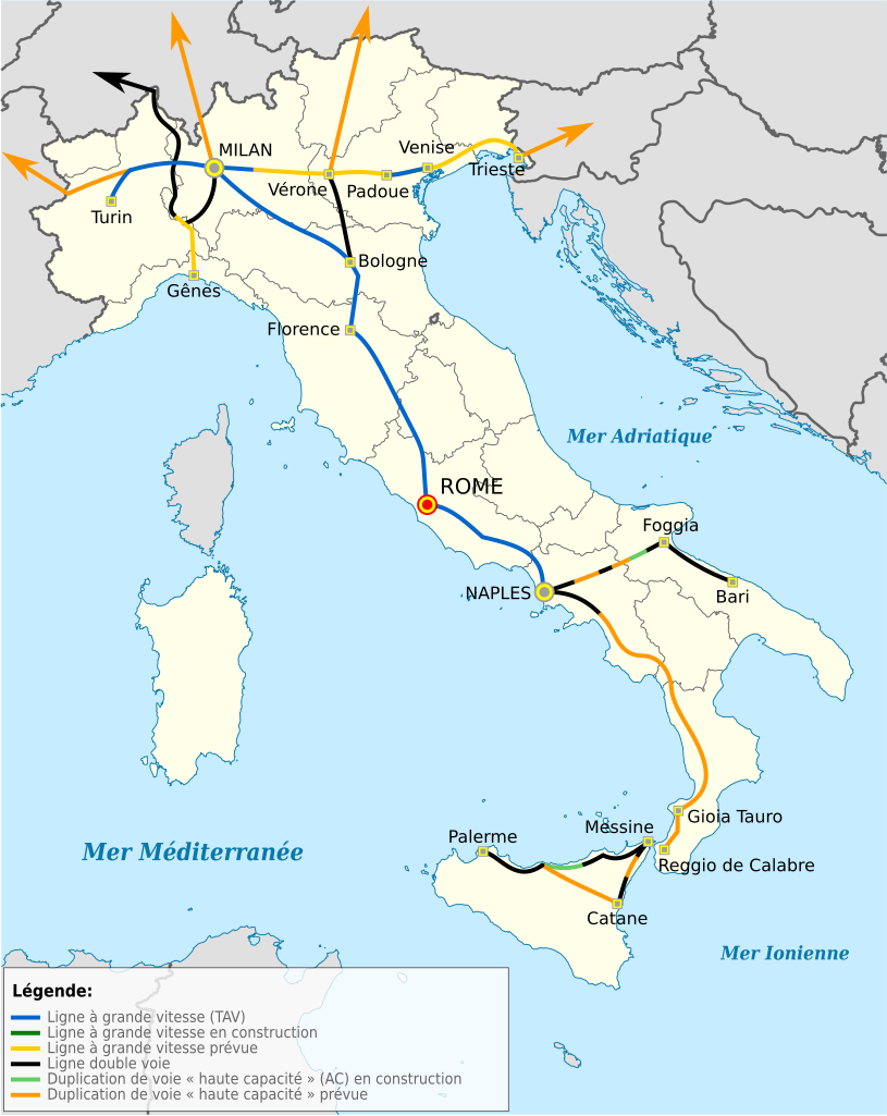
Deutsch: Hochgeschwindigkeitsstrecken in Italien auf der Positionskarte von Italien Quadratische Plattkarte, N-S-Streckung 132,898 %. Geographische Begrenzung der Karte:* N: 47.4° N * S: 35.3° N * W: 6.2° O * O: 19.0° O English: Hi-speed railway lines in Italy on Location map of Italy Equirectangular projection, N/S stretching 132,898 %. Geographic limits of the map: * N: 47.4° N * S: 35.3° N * W: 6.2° E * E: 19.0° E Italiano: Mappa di localizzazione dell'Italia
Proiezione equirettangolare, allargamento N/S 132,898 %. Limiti geografici della mappa: * N: 47.4° N * S: 35.3° N * W: 6.2° E * E: 19.0° E Français : Lignes ferroviaires principales (haute vitesse) en Italie, sur une carte géolocalisée du territoire italien Projection équirectangulare (N/S 132,898 %). Limites géographiques de la carte: * N: 47.4° N * S: 35.3° N * W: 6.2° E * E: 19.0° E |
| Date | (UTC) |
| Source |
This file was derived from: |
| Author |
This W3C-unspecified vector image was created with Inkscape . |
| Other versions |
 |
| Attribution (required by the license) | © Domaina / Wikimedia Commons / |


W3C-validity not checked.
| This is a retouched picture, which means that it has been digitally altered from its original version. The original can be viewed here: Italy location map.svg:
|

|
This SVG file contains embedded text that can be translated into your language, using any capable SVG editor, text editor or the SVG Translate tool. For more information see: About translating SVG files. |
Licensing[edit]
This file is licensed under the Creative Commons Attribution-Share Alike 3.0 Unported license.
Attribution: Domaina
- You are free:
- to share – to copy, distribute and transmit the work
- to remix – to adapt the work
- Under the following conditions:
- attribution – You must give appropriate credit, provide a link to the license, and indicate if changes were made. You may do so in any reasonable manner, but not in any way that suggests the licensor endorses you or your use.
- share alike – If you remix, transform, or build upon the material, you must distribute your contributions under the same or compatible license as the original.

|
Permission is granted to copy, distribute and/or modify this document under the terms of the GNU Free Documentation License, Version 1.2 or any later version published by the Free Software Foundation; with no Invariant Sections, no Front-Cover Texts, and no Back-Cover Texts. A copy of the license is included in the section entitled GNU Free Documentation License. |
Original upload log[edit]
This image is a derivative work of the following images:
- File:Italy_TAV.png licensed with Cc-by-sa-3.0-migrated, GFDL
- 2010-02-23T20:45:36Z Pcongre 611x713 (37248 Bytes)
- 2008-12-16T18:42:12Z KevinCuddeback 611x713 (37133 Bytes) Reverted to version as of 18:41, 16 December 2008
- 2008-12-16T18:41:42Z KevinCuddeback 611x713 (39524 Bytes) Reverted to version as of 13:15, 13 April 2007
- 2008-12-16T18:41:21Z KevinCuddeback 611x713 (37133 Bytes) {{Information |Description= |Source= |Date= |Author= |Permission= |other_versions= }}
- 2008-12-16T18:37:24Z KevinCuddeback 611x713 (37133 Bytes) {{Information |Description= English: {{en|Hi-speed railway lines in Italy}} {{de|Hochgeschwindigkeitsstrecken in Italien}} |Source= own, revision of earlier work by {Sinigagl|user:Sinigagl} |Date= 2008-12-16 |Author=Sinigag
- 2007-04-13T13:15:01Z Sinigagl 611x713 (39524 Bytes)
- 2006-09-28T14:56:27Z Sinigagl 611x713 (39469 Bytes) == Dettagli == {{Information| |Description=Hi-speed railways in Italy |Source=own |Date=28.09.2006 |Author=Sinigagl |Permission= |other_versions= }} == Licensing == {{GFDL}} [[Category:Maps of Italy]]
- File:Italy_location_map.svg licensed with Cc-by-sa-3.0, GFDL
- 2010-09-11T06:42:56Z Citypeek 1034x1299 (1484466 Bytes) Made one layer of the entire picture. Better for adding new stuff.
- 2009-08-22T09:58:43Z Erinaceus 1034x1299 (1470342 Bytes) updating borders after important variation (http://www.gazzettaufficiale.it/guridb/dispatcher?service=1&datagu=2009-08-14&task=dettaglio&numgu=188&redaz=009G0127&tmstp=1250276942469)
- 2009-05-06T12:38:21Z NordNordWest 1034x1299 (1035834 Bytes) corr
- 2009-03-12T18:27:05Z NordNordWest 1032x1267 (1032937 Bytes) corr
- 2008-07-06T16:30:54Z NordNordWest 1032x1267 (1034196 Bytes) {{Information |Description= {{de|Positionskarte von [[:de:Italien|Italien]]}} Quadratische Plattkarte, N-S-Streckung 130 %. Geographische Begrenzung der Karte: * N: 47.4° N * S: 35.3° N * W: 6.2° O * O: 19.0° O {{en|Locat
Uploaded with derivativeFX
File history
Click on a date/time to view the file as it appeared at that time.
| Date/Time | Thumbnail | Dimensions | User | Comment | |
|---|---|---|---|---|---|
| current | 16:45, 20 April 2013 | | 1,034 × 1,299 (1,016 KB) | Citypeek (talk | contribs) | Cleanup of file. Valid SVG now. |
| 08:10, 4 August 2012 |  | 1,034 × 1,299 (883 KB) | Domaina (talk | contribs) | == {{int:filedesc}} == {{Information |Description= {{de|Hochgeschwindigkeitsstrecken in Italien auf der Positionskarte von Italien}} Quadratische Plattkarte, N-S-Streckung 132,898 %. Geographische Begrenzung der Karte: * N: 47.4° N * S... |
You cannot overwrite this file.
File usage on Commons
The following 2 pages use this file:
File usage on other wikis
The following other wikis use this file:
- Usage on en.wiktionary.org
- Usage on es.wikipedia.org
- Usage on fr.wikipedia.org
- Usage on ru.wikipedia.org
- Usage on uk.wikipedia.org
- Usage on www.wikidata.org