File:Italy 1796 AD.png
Zur Navigation springen
Zur Suche springen

Größe dieser Vorschau: 419 × 600 Pixel. Weitere Auflösungen: 167 × 240 Pixel | 335 × 480 Pixel | 1.007 × 1.442 Pixel.
Originaldatei (1.007 × 1.442 Pixel, Dateigröße: 92 KB, MIME-Typ: image/png)
Bildtexte
Kurzbeschreibungen
Ergänze eine einzeilige Erklärung, was diese Datei darstellt.
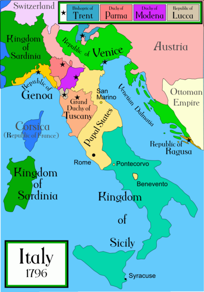
Political map of Italy 1796
Beschreibung[Bearbeiten]
| Beschreibung |
A political map of Italy in early 1796, before the Napoleonic wars, created by MapMaster.
|
||||||||
| Quelle | Eigenes Werk | ||||||||
| Urheber | Capmo | ||||||||
| Genehmigung (Weiternutzung dieser Datei) |
Ich, der Urheber dieses Werkes, veröffentliche es unter der folgenden Lizenz:
|
||||||||
| Andere Versionen |
[]
|


|
Dieses Bild des Typs Historical map sollte als Vektorgrafik im SVG-Format neu erstellt werden. Vektorformate haben zahlreiche Vorteile; weitere Information unter Commons:Media for cleanup. Wenn dir eine SVG-Version dieses Bildes vorliegt, so lade diese bitte hoch. Nach dem Hochladen der Datei ist diese Vorlage auf der aktuellen Bildbeschreibungsseite durch die Vorlage {{Vector version available}}, oder kürzer {{Vva}}, zu ersetzen. Es ist empfohlen die neue SVG-Datei „Italy 1796 AD.svg“ zu nennen – dann benötigt die Vorlage vector version available (bzw. vva) keinen Parameter.
|
Dateiversionen
Klicke auf einen Zeitpunkt, um diese Version zu laden.
| Version vom | Vorschaubild | Maße | Benutzer | Kommentar | |
|---|---|---|---|---|---|
| aktuell | 01:26, 21. Apr. 2009 | | 1.007 × 1.442 (92 KB) | Capmo (Diskussion | Beiträge) | pallette reduction to 256 colours |
| 03:40, 16. Apr. 2007 |  | 1.007 × 1.442 (324 KB) | MapMaster (Diskussion | Beiträge) | slightly improved | |
| 03:25, 22. Nov. 2006 |  | 629 × 901 (180 KB) | MapMaster (Diskussion | Beiträge) | Slightly improved map: better color, location of capital cities, etc | |
| 04:29, 18. Okt. 2006 |  | 1.266 × 1.814 (418 KB) | MapMaster (Diskussion | Beiträge) | I uploaded a slightly improved map | |
| 03:55, 17. Okt. 2006 |  | 1.267 × 1.821 (429 KB) | MapMaster (Diskussion | Beiträge) | A political map of Italy in early 1796, before the Napoleonic wars, created by MapMaster. |
Du kannst diese Datei nicht überschreiben.
Dateiverwendung
Die folgenden 84 Seiten verwenden diese Datei:
- Atlas of Italy
- Atlas of Sardinia
- Maps of Italy
- User:MapMaster
- User talk:MapMaster
- File:Balkans Animation 1800-2008.gif
- File:Duchy of Carinthia-1000 AD.svg
- File:Italia 1000 AD-Ido.svg
- File:Italia 1796 - HE.svg
- File:Italy 1000 AD-de.svg
- File:Italy 1000 AD-es.svg
- File:Italy 1000 AD-he.svg
- File:Italy 1000 AD-hu.svg
- File:Italy 1000 AD-ru.svg
- File:Italy 1000 AD.svg
- File:Italy 1494 AD-ar.png
- File:Italy 1494 AD-hu.svg
- File:Italy 1494 AD.png
- File:Italy 1796.png (Dateiweiterleitung)
- Maps of Italy
- File:Italy 1796 AD.png
- User:MapMaster
- User talk:MapMaster
- File:Italy 1000 AD.svg
- Atlas of Italy
- File:Italy 1494 AD.png
- File:Italy and Illyria 1084 AD.svg
- File:Italy 1796 AD-it.png
- Atlas of Sardinia
- Category talk:Grand Duchy of Tuscany
- File:Italy 1796 AD-sv.png
- File:Balkans Animation 1800-2008.gif
- File:Italy 1000 AD-de.svg
- File:Italy 1000 AD-es.svg
- File:Italy 1000 AD-hu.svg
- File:Italy 1000 AD-he.svg
- File:Italy 1000 AD-ru.svg
- File:Italy and Illyria 1084 AD-ru.svg
- File:Italy 1796 heb.jpg
- File:Italia 1796 - HE.svg
- File:Italy 1796 AD-ar.png
- File:Italy 1494 AD-ar.png
- File:Duchy of Carinthia-1000 AD.svg
- File:Italy 1796 AD-el.png
- File:Italy and Illyria 1084 AD-hu.svg
- File:Italy 1494 AD-hu.svg
- File:Italy 1796 AD-ko.png
- Template:Other versions/Italy 1796 AD
- File:Italia 1000 AD-Ido.svg
- File:Italy 1796 AD-ar.png
- File:Italy 1796 AD-el.png
- File:Italy 1796 AD-it.png
- File:Italy 1796 AD-ko.png
- File:Italy 1796 AD-sv.png
- File:Italy 1796 AD.png
- File:Italy 1796 heb.jpg
- File:Italy and Illyria 1084 AD-hu.svg
- File:Italy and Illyria 1084 AD-ru.svg
- File:Italy and Illyria 1084 AD.svg
- Template:Other versions/Italy 1796 AD
- Category:Grand Duchy of Tuscany
- Category:Ligurian Republic
- Category:Tuscany by decade
- Category:Tuscany in the 1560s
- Category:Tuscany in the 1570s
- Category:Tuscany in the 1580s
- Category:Tuscany in the 1590s
- Category:Tuscany in the 1600s
- Category:Tuscany in the 1620s
- Category:Tuscany in the 1650s
- Category:Tuscany in the 1660s
- Category:Tuscany in the 16th century
- Category:Tuscany in the 1750s
- Category:Tuscany in the 1770s
- Category:Tuscany in the 1780s
- Category:Tuscany in the 17th century
- Category:Tuscany in the 1800s
- Category:Tuscany in the 1810s
- Category:Tuscany in the 1820s
- Category:Tuscany in the 1830s
- Category:Tuscany in the 1850s
- Category:Tuscany in the 18th century
- Category:Tuscany in the 19th century
- Category talk:Grand Duchy of Tuscany
Globale Dateiverwendung
Die nachfolgenden anderen Wikis verwenden diese Datei:
- Verwendung auf ar.wikipedia.org
- Verwendung auf ast.wikipedia.org
- Verwendung auf azb.wikipedia.org
- Verwendung auf br.wikipedia.org
- Verwendung auf ca.wikipedia.org
- Verwendung auf cs.wikipedia.org
- Verwendung auf de.wikipedia.org
- Verwendung auf en.wikipedia.org
- Verwendung auf es.wikipedia.org
- Verwendung auf et.wikipedia.org
- Verwendung auf eu.wikipedia.org
- Verwendung auf fa.wikipedia.org
- Verwendung auf fi.wikipedia.org
- Verwendung auf fr.wikipedia.org
- Verwendung auf gl.wikipedia.org
- Verwendung auf he.wikipedia.org
- Verwendung auf hi.wikipedia.org
- Verwendung auf hr.wikipedia.org
- Verwendung auf hy.wikipedia.org
- Verwendung auf id.wikipedia.org
- Verwendung auf is.wikipedia.org
- Verwendung auf ja.wikipedia.org
- Verwendung auf ka.wikipedia.org
- Verwendung auf la.wikipedia.org
- Verwendung auf li.wikipedia.org
Weitere globale Verwendungen dieser Datei anschauen.
Kategorien:
- 1796 in Italy
- 1796 maps of Europe
- Maps of the history of the Italian Peninsula
- Maps of historical states of Italy
- Maps of the Republic of Venice
- Maps of 18th-century Italy
- Maps of the Republic of Genoa
- Maps of the Kingdom of Sardinia
- Maps of the Grand Duchy of Tuscany
- Maps of the Republic of Lucca
- Maps of the Duchy of Parma and Piacenza
- Maps of Duchy of Modena and Reggio
- Maps of the Papal States
- 1796 in the Papal States
- Maps of the Kingdom of Sicily