File:Italy and Illyria 1084 AD.svg
Zur Navigation springen
Zur Suche springen

Größe der PNG-Vorschau dieser SVG-Datei: 478 × 600 Pixel. Weitere Auflösungen: 191 × 240 Pixel | 383 × 480 Pixel | 612 × 768 Pixel | 816 × 1.024 Pixel | 1.633 × 2.048 Pixel | 586 × 735 Pixel.
Originaldatei (SVG-Datei, Basisgröße: 586 × 735 Pixel, Dateigröße: 522 KB)
Bildtexte
Kurzbeschreibungen
Ergänze eine einzeilige Erklärung, was diese Datei darstellt.

Beschreibung
[Bearbeiten]| Beschreibung |
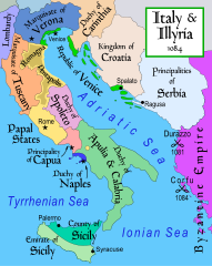
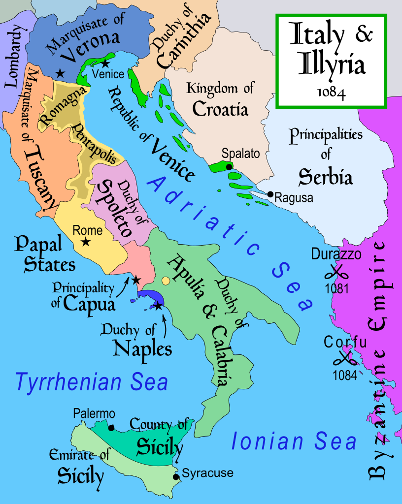
English: Map of Italy and the Illyrian coast in the year 1084.
Part of a series of maps on the history of Italy:
|
| Datum | |
| Quelle | Eigenes Werk |
| Urheber | MapMaster |
| Andere Versionen |
[]
|
| SVG‑Erstellung |


References
[Bearbeiten]
- This map from Allyn & Bacon, Longman, textbook publishers.
- Bjorklund, Oddvar; Holmboe, Haakon; Rohr, Anders (1970) Historical Atlas of the World, Barnes & Noble, NY, SBN: 389-00253-4.
- Hammond Atlas Corporation (2007) Hammond Historical World Atlas.
- Matthew, Donald (1989) Atlas of Medieval Europe, Time-Life Books.
- This map of 1000 AD Italy from Fordham University, adapted from Muir's Historical Atlas, (1911).
- This map of 1050 AD Italy, from the 1923 The Historical Atlas by William R. Shepherd
- This Wikipedia map of the w:en:Holy Roman Empire
- Šišić, Ferdo (1990) Povijest Hrvata u vrijeme narodnih vladara & the Baška tablet (to denote the territorial integrity of Croatia; islands, coastal borders etc.)
Lizenz
[Bearbeiten]
Ich, der Urheber dieses Werkes, veröffentliche es unter der folgenden Lizenz:
Diese Datei ist unter der Creative-Commons-Lizenz „Namensnennung – Weitergabe unter gleichen Bedingungen 2.5 generisch“ (US-amerikanisch) lizenziert.
- Dieses Werk darf von dir
- verbreitet werden – vervielfältigt, verbreitet und öffentlich zugänglich gemacht werden
- neu zusammengestellt werden – abgewandelt und bearbeitet werden
- Zu den folgenden Bedingungen:
- Namensnennung – Du musst angemessene Urheber- und Rechteangaben machen, einen Link zur Lizenz beifügen und angeben, ob Änderungen vorgenommen wurden. Diese Angaben dürfen in jeder angemessenen Art und Weise gemacht werden, allerdings nicht so, dass der Eindruck entsteht, der Lizenzgeber unterstütze gerade dich oder deine Nutzung besonders.
- Weitergabe unter gleichen Bedingungen – Wenn du das Material wiedermischst, transformierst oder darauf aufbaust, musst du deine Beiträge unter der gleichen oder einer kompatiblen Lizenz wie das Original verbreiten.
derivative works
[Bearbeiten]
Abgeleitete Werke dieser Datei: Italy and Illyria 1084 v2-ar.svg
Dateiversionen
Klicke auf einen Zeitpunkt, um diese Version zu laden.
| Version vom | Vorschaubild | Maße | Benutzer | Kommentar | |
|---|---|---|---|---|---|
| aktuell | 19:19, 22. Okt. 2017 | | 586 × 735 (522 KB) | Ras67 (Diskussion | Beiträge) | frame removed |
| 12:16, 23. Nov. 2011 |  | 588 × 735 (644 KB) | Kathovo (Diskussion | Beiträge) | Reverted to version as of 12:20, 29 July 2007 not an svg | |
| 18:06, 23. Jan. 2011 |  | 480 × 600 (224 KB) | Er-vet-en (Diskussion | Beiträge) | whoops, sorry for this | |
| 18:04, 23. Jan. 2011 |  | 480 × 600 (224 KB) | Er-vet-en (Diskussion | Beiträge) | resize | |
| 17:50, 23. Jan. 2011 |  | 744 × 1.052 (224 KB) | Er-vet-en (Diskussion | Beiträge) | plit and some islands are are actually in Croatia's dominion from about 1076 (since the previous map relied on maps from earlier) This is proven by the acclaimed historian Ferdo Šišić, and the culturally significant Bashka tablet (which proved that ki | |
| 12:20, 29. Jul. 2007 |  | 588 × 735 (644 KB) | Lokal Profil (Diskussion | Beiträge) | Cleaned up code (specifically loads of empty groups) | |
| 05:43, 15. Apr. 2007 |  | 588 × 735 (695 KB) | MapMaster (Diskussion | Beiträge) | Minor changes | |
| 03:56, 13. Feb. 2007 |  | 588 × 735 (694 KB) | MapMaster (Diskussion | Beiträge) | Map of Italy and the Illyrian coast in the year 1084 |
Du kannst diese Datei nicht überschreiben.
Dateiverwendung
Die folgenden 75 Seiten verwenden diese Datei:
- Atlas of Croatia
- Atlas of Slovenia
- User:J budissin/Uploads/BiH/2017 October 21-31
- User:MapMaster
- File:Duchy of Carinthia-1000 AD.svg
- File:Italia 1000 AD-Ido.svg
- File:Italia 1796-ca.svg
- File:Italia 1796-es.svg
- File:Italia 1796-fr.svg
- File:Italia 1796.svg
- File:Italy 1000 AD-de.svg
- File:Italy 1000 AD-el.png
- File:Italy 1000 AD-es.svg
- File:Italy 1000 AD-he.svg
- File:Italy 1000 AD-ru.svg
- File:Italy 1000 AD.svg
- File:Italy 1494 AD-ar.png
- File:Italy 1494 AD.png
- File:Italy 1494 el.png
- File:Italy 1796-hu.svg
- File:Italy 1796.svg
- File:Italy 1796 AD-ca.svg
- File:Italy 1796 AD-el.png
- File:Italy 1796 de.svg
- File:Italy 1796 heb.jpg
- File:Italy 1796 it.svg
- File:Italy and Illyria 1084 AD-ca.svg
- File:Italy and Illyria 1084 AD-cs.svg
- File:Italy and Illyria 1084 AD-es.svg
- File:Italy and Illyria 1084 AD-fr.svg
- File:Italy and Illyria 1084 AD-hu.svg
- File:Italy and Illyria 1084 AD-it.svg
- File:Italy and Illyria 1084 AD-ru.svg
- File:Italy and Illyria 1084 AD-sv.png
- File:Italy and Illyria 1084 AD-vi.svg
- File:Italy and Illyria 1084 AD-zh.png
- File:Italy and Illyria 1084 AD-zh.svg
- File:Italy and Illyria 1084 AD.svg
- File:Italy and Illyria 1084 v2-ar.svg
- File:Italy and Illyria 1084 v2-es.svg
- File:Italy and Illyria 1084 v2.svg (Dateiweiterleitung)
- User:MapMaster
- File:Italy 1000 AD.svg
- Atlas of Croatia
- Atlas of Slovenia
- File:Italy 1000 AD-de.svg
- File:Italy 1000 AD-es.svg
- File:Italy and Illyria 1084 AD-cs.svg
- File:Italy 1000 AD-he.svg
- File:Italy and Illyria 1084 AD-it.svg
- File:Italy 1000 AD-ru.svg
- File:Italy and Illyria 1084 AD-ru.svg
- File:Italy 1796 heb.jpg
- File:Italia 1796.svg
- File:Italy 1494 AD-ar.png
- File:Duchy of Carinthia-1000 AD.svg
- File:Italy and Illyria 1084 v2-ar.svg
- File:Italia 1796-es.svg
- File:Italy 1796.svg
- File:Italia 1796-fr.svg
- File:Italy and Illyria 1084 v2 pt.svg
- File:Italy 1796 de.svg
- File:Italy 1796 it.svg
- File:Italy and Illyria 1084 v2-es.svg
- File:Italy 1796 AD-el.png
- File:Italy 1494 el.png
- File:Italy 1000 AD-el.png
- Template:Other versions/Italy 1796 AD
- File:Italy 1796-hu.svg
- File:Italia 1000 AD-Ido.svg
- File:Italia 1796-ca.svg
- File:Italy 1796 AD-ca.svg
- File:Italy and Illyria 1084 v2 pt.svg
- Template:Other versions/Italy 1796 AD
- Template:Other versions/Italy and Illyria 1084 AD
Globale Dateiverwendung
Die nachfolgenden anderen Wikis verwenden diese Datei:
- Verwendung auf ar.wikipedia.org
- Verwendung auf azb.wikipedia.org
- Verwendung auf bg.wikipedia.org
- Verwendung auf bn.wikipedia.org
- Verwendung auf bs.wikipedia.org
- Verwendung auf ca.wikipedia.org
- Verwendung auf cs.wikipedia.org
- Verwendung auf da.wikipedia.org
- Verwendung auf de.wikipedia.org
- Verwendung auf el.wikipedia.org
- Verwendung auf en.wikipedia.org
- 1084
- Robert Guiscard
- Republic of Florence
- Battle of Dyrrhachium (1081)
- Sikelgaita
- User:MapMaster
- Domenico Selvo
- Vitale Faliero
- History of Islam in southern Italy
- Norman conquest of southern Italy
- Byzantine–Norman wars
- County of Apulia and Calabria
- Terre Matildiche
- Amicus of Giovinazzo
- User:Falcaorib/Italy
- Verwendung auf et.wikipedia.org
Weitere globale Verwendungen dieser Datei anschauen.
Metadaten
Kategorien:
- Battle of Dyrrhachium (1081)
- Maps of 11th-century Italy
- Maps of the Republic of Venice
- Maps of the Duchy of Spoleto
- Principality of Capua
- Maps of the Kingdom of Sicily
- Emirate of Sicily
- County of Sicily
- SVG maps of the history of Italy
- Marquisate of Tuscany
- Maps of the Papal States
- Papal States in the 1080s
- Maps of the history of Croatia in the Middle Ages
- Maps of 11th-century Serbia
- Maps of medieval Bosnian and neighboring states
- Maps of the history of the medieval Balkans
- Constantine Bodin
- English-language SVG maps showing history
- Maps of the history of Bosnia and Herzegovina in the Early Middle Ages