File:Japan natural location map with side map of the Ryukyu Islands.jpg
跳转到导航
跳转到搜索

本预览的尺寸:664 × 600像素。 其他分辨率:266 × 240像素 | 531 × 480像素 | 850 × 768像素 | 1,133 × 1,024像素 | 2,497 × 2,256像素。
原始文件 (2,497 × 2,256像素,文件大小:830 KB,MIME类型:image/jpeg)
说明
说明
添加一行文字以描述该文件所表现的内容
东北 海岸
摘要
[编辑]| 描述 |
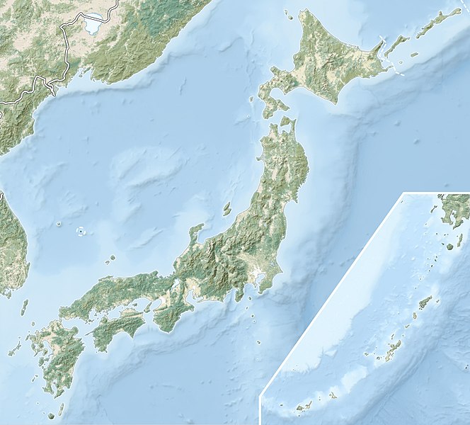
English: Natural Location map of Japan
Equirectangular projection. Geographic limits to locate objects in the main map with the main islands:
Geographic limits to locate objects in the side map with the Ryukyu Islands:
|
||
| 日期 | |||
| 来源 |
|
||
| 作者 | Alexrk2 | ||
| 授权 (二次使用本文件) |
本文件采用知识共享署名-相同方式共享 3.0 未本地化版本许可协议授权。
|
||
| 其他版本 |
|


文件历史
点击某个日期/时间查看对应时刻的文件。
| 日期/时间 | 缩略图 | 大小 | 用户 | 备注 | |
|---|---|---|---|---|---|
| 当前 | 2022年3月9日 (三) 21:41 | | 2,497 × 2,256(830 KB) | Sting(留言 | 贡献) | Natural Earth land cover data for Ryukyu Islands |
| 2018年6月22日 (五) 09:44 |  | 2,497 × 2,256(794 KB) | Mardetanha(留言 | 贡献) | Reverted to version as of 19:56, 22 March 2011 (UTC) | |
| 2011年3月22日 (二) 19:56 |  | 2,497 × 2,256(794 KB) | Alexrk2(留言 | 贡献) | RGB | |
| 2011年3月22日 (二) 19:07 |  | 2,497 × 2,256(745 KB) | Chumwa(留言 | 贡献) | RGB mode | |
| 2011年3月21日 (一) 21:08 |  | 2,497 × 2,256(1.54 MB) | Alexrk2(留言 | 贡献) | == {{int:filedesc}} == {{Information |Description= {{en|Natural Location map of Japan Equirectangular projection. Geographic limits to locate objects in the main map with the main islands: * N: 45°51'37" N (45.86°N) * S: 30°01'13" N (30. |
您不可以覆盖此文件。
文件用途
以下6个页面使用本文件:
- User:Chumwa/Gallery
- File:Japan bluemarble location map with side map of the Ryukyu Islands.jpg
- File:Japan location map with side map of the Ryukyu Islands.svg
- File:Japan natural location map with side map of the Ryukyu Islands.jpg
- File:Japan relief location map with side map of the Ryukyu Islands.jpg
- File:Pacific earthquakes off the coast of Japan March 2022.png
全域文件用途
以下其他wiki使用此文件:
- ace.wikipedia.org上的用途
- als.wikipedia.org上的用途
- ar.wikipedia.org上的用途
- arz.wikipedia.org上的用途
- ast.wikipedia.org上的用途
- as.wikipedia.org上的用途
- azb.wikipedia.org上的用途
- az.wikipedia.org上的用途
- Hokkaydo
- Kyuşu
- Fuci
- Honşu
- İtsukuşima
- Asama dağı
- Şablon:Yer xəritəsi Yaponiya
- Tohoku zəlzələsi və sunamisi (2011)
- Fukuşima-1 AES
- Böyük Hanşin zəlzələsi
- Böyük Kanto zəlzələsi
- Hoey zəlzələsi
- Mino-Ovari zəlzələsi (1891)
- Yapon çökəkliyi
- Ryukyu adaları
- Osumi boğazı
- Sanqar boğazı
- Koreya boğazı
- Tsuşima boğazı
- Harim dənizi
- Yatsuşiro dənizi
- Hiuqa dənizi
- Daxili Yapon dənizi
- Atsumi yarımadası
- Naqasaki yarımadası
- İzu yarımadası
- Simabara yarımadası
- Şiretoko yarımadası
- Nosuke yarımadası
查看此文件的更多全域用途。