File:Japanese Empire2.png
Sautar la navigacion
Sautar la recèrca
Talha d'aquesta previsualizacion: 515 × 599 pixèls. Autras resolucions : 206 × 240 pixèls | 412 × 480 pixèls | 660 × 768 pixèls | 1 032 × 1 201 pixèls.
Fichièr d'origina (1 032 × 1 201 pixèl, talha del fichièr: 927 Ko, tipe MIME: image/png)
Llegendes
Llegendes
Afegeix una explicació d'una línia del que representa aquest fitxer

|
Aquesta imatge (de tipus military map) s'hauria de tornar a crear utilitzant gràfics vectorials com ara un fitxer SVG. Això té diversos avantatges; en trobareu més informació a Commons:Media for cleanup. Si ja disposeu d'una versió d'aquesta imatge en format SVG, us preguem que la pengeu; després, reemplaceu aquesta plantilla amb la plantilla {{Vector version available|nom nou de la imatge.svg}} en aquesta imatge.
|
Descripcion[modificar]
| Descripcion |
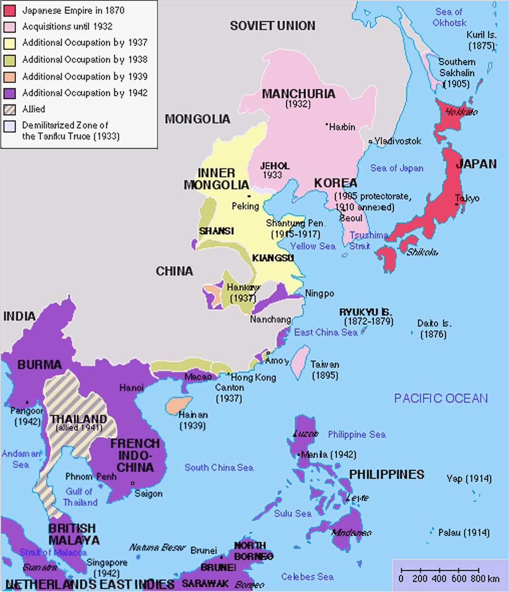
English: Original map was created by Kokiri, based in part on File:BlankMap-World.png. Subsequent modifications to colors performed by Huhsunqu. Additional corrections (fixed Ryukyu Islands, Sichuan, grammar in table) by Markalexander100. |
||||||||
| Data | (original upload date at English Wikipedia) | ||||||||
| Font |
Ce fichier est dérivé de : Japanese Empire.png |
||||||||
| Autor | Kokiri de Wikipèdia en anglés, modifications by Huhsunqu and Markalexander100. | ||||||||
| Permission (Reütilizacion d'aqueste fichièr) |
|
||||||||
| Autras versions |
Derivative works of this file: |

.png)
Registre original de càrregues[modificar]
The original upload log was here. The usernames refer to the English Wikipedia. Not to be confused with File:Japanese empire.png.
04:00, 6 October 2005 . . Huhsunqu (talk | contribs | block) 508 × 591 (44,305 bytes)02:42, 21 August 2004 . . Nanshu (talk | contribs | block) 508 × 591 (45,178 bytes)09:38, 18 August 2004 . . Kokiri (talk | contribs | block) 508 × 591 (46,867 bytes) (map of the Japanese Empire, drawn myself)
Istoric del fichièr
Clicar sus una data e una ora per veire lo fichièr tal coma èra a aqueste moment
| Data e ora | Miniatura | Dimensions | Utilizaire | Comentari | |
|---|---|---|---|---|---|
| actual | 3 març de 2023 a 12.26 | | 1 032 × 1 201 (927 Ko) | Hohum (discussion | contribucions) | Brighten |
| 3 març de 2023 a 12.24 |  | 1 032 × 1 201 (944 Ko) | Hohum (discussion | contribucions) | less garish colours | |
| 10 genièr de 2023 a 03.53 |  | 1 032 × 1 201 (1 020 Ko) | Artanisen (discussion | contribucions) | Added allied color. Thailand was in a coerced alliance (1941) thus part of the empire | |
| 22 junh de 2022 a 06.20 |  | 1 032 × 1 201 (683 Ko) | Crab2814 (discussion | contribucions) | Removed Tongking- France gave Japan military access to that region in 1940, not an occupational right. Fixed Sakhalin and Hainan. Removed Thailand, which was allied not occupied by Japan. | |
| 3 agost de 2020 a 11.58 |  | 1 437 × 1 201 (1,8 Mo) | Artanisen (discussion | contribucions) | Bigger size and sharper version of the same map. The rest is the same. | |
| 5 julhet de 2007 a 11.47 |  | 707 × 591 (32 Ko) | Mahahahaneapneap (discussion | contribucions) | pngcrushed | |
| 27 mai de 2007 a 01.31 |  | 707 × 591 (48 Ko) | Gryffindor (discussion | contribucions) | {{svg}} {{GFDL}} Modified version of Image:Japanese_Empire.png. Fixed Ryukyu Islands, Sichuan, grammar in table. Category:Maps of the history of Japan Category:Maps of the history of Korea Category:Maps of the history of Vietnam [[Categ | |
| 27 febrièr de 2007 a 15.13 |  | 508 × 591 (36 Ko) | Cristan (discussion | contribucions) | Optimized using PNGOUT | |
| 22 decembre de 2005 a 11.24 |  | 508 × 591 (47 Ko) | Markalexander100 (discussion | contribucions) | {{GFDL}} Modified version of Image:Japanese_Empire.png. Fixed Ryukyu Islands, Sichuan, grammar in table. |
Podètz pas remplaçar aqueste fichièr.
Paginas que contenon lo fichièr
Las paginas çaijós compòrtan aqueste imatge :
- Atlas of Brunei
- Atlas of Cambodia
- Atlas of Indonesia
- Atlas of Japan
- Atlas of Laos
- Atlas of Malaysia
- Atlas of Myanmar
- Atlas of Singapore
- Atlas of Taiwan
- Atlas of Thailand
- Atlas of Vietnam
- Atlas of World War II
- Atlas of colonialism
- Atlas of the People's Republic of China
- User:Chumwa/OgreBot/Transport Maps/2020 August 1-10
- User:Chumwa/OgreBot/Transport Maps/2022 June 21-30
- User:Chumwa/OgreBot/Travel and communication maps/2020 August 1-10
- User:Chumwa/OgreBot/Travel and communication maps/2022 June 21-30
- User:Magog the Ogre/Maps of conflicts/2020 August
- User:Magog the Ogre/Maps of conflicts/2022 June
- User:Magog the Ogre/Maps of conflicts/2023 January
- User:Magog the Ogre/Maps of conflicts/2023 March
- File:Império Japonês (1870-1942).png
Usatge global del fichièr
Los autres wikis seguents utilizan aqueste imatge :
- Utilizacion sus af.wikipedia.org
- Utilizacion sus ar.wikipedia.org
- Utilizacion sus ca.wikipedia.org
- Utilizacion sus cs.wikipedia.org
- Utilizacion sus de.wikipedia.org
- Utilizacion sus en.wikipedia.org
- Utilizacion sus eu.wikipedia.org
- Utilizacion sus fa.wikipedia.org
- Utilizacion sus fi.wikipedia.org
- Utilizacion sus fr.wikipedia.org
- Utilizacion sus gl.wikipedia.org
- Utilizacion sus hak.wikipedia.org
- Utilizacion sus he.wikipedia.org
- Utilizacion sus hy.wikipedia.org
- Utilizacion sus it.wikipedia.org
- Utilizacion sus ja.wikipedia.org
- Utilizacion sus min.wikipedia.org
- Utilizacion sus mk.wikipedia.org
- Utilizacion sus ms.wikipedia.org
- Utilizacion sus nl.wikipedia.org
- Utilizacion sus oc.wikipedia.org
- Utilizacion sus pam.wikipedia.org
- Utilizacion sus pt.wikipedia.org
- Utilizacion sus ro.wikipedia.org
Veire l'utilizacion globala d'aqueste fichièr.
Metadonadas
Categorias :
- Empire of Vietnam in 1945
- Maps of the Empire of Japan
- Maps of the history of Korea
- Maps of the history of Vietnam
- Maps of the history of Laos
- Maps of the history of Cambodia
- Maps of the history of the Philippines
- Maps of the Republic of China (1912–1949)
- Maps of the history of Indonesia
- Maps of British Malaya
- Maps of Burma during World War II
- Maps of the history of Taiwan
- Maps of the history of Thailand