File:Joggins mcr1.jpg
Jump to navigation
Jump to search

Size of this preview: 799 × 173 pixels. Other resolutions: 320 × 69 pixels | 640 × 139 pixels | 1,024 × 222 pixels | 1,280 × 277 pixels | 9,324 × 2,020 pixels.
Original file (9,324 × 2,020 pixels, file size: 12.24 MB, MIME type: image/jpeg)
Captions
Captions
Add a one-line explanation of what this file represents
Summary[edit]
| Description |
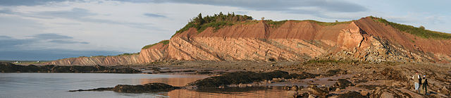
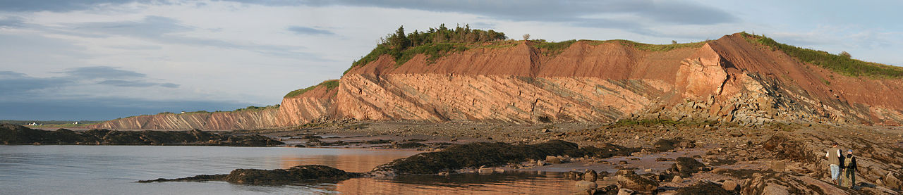
English: View of the lower 600 m of the Joggins Formation (Pennsylvanian), part of the Joggins Fossil Cliffs UNESCO World Heritage Site, seen from Coal Mine Point. The tilted Joggins beds are overlain by reddish glacial deposits (till) of Pleistocene age.
Français : Fue montrant les 600 mètres de la base de la formation de Joggins, en Nouvelle Écosse (Canada). Ces falaises du carbonifère sont un site naturel inscrit au Patrimoine mondial de l'UNESCO. Les lits inclinés de Joggins sont recouverts par des dépôts glaciaires rougeâtres (till) du Pléistocène.
Deutsch: Die unteren 600 m der Joggins-Formation (Oberkarbon), Teil des Joggins Fossil Cliff UNESCO-Weltnaturerbes, von Coal Mine Point aus gesehen. Die verkippten Joggins-Schichten werden von rötlichem Geschiebemergel des Pleistozäns winkeldiskordant überlagert. |
| Date | |
| Source | Own work |
| Author | Michael C. Rygel |
| Permission (Reusing this file) |
If used outside of Wikipedia or Wikimedia Commons, please acknowledge the source of this photo (Michael C. Rygel via Wikimedia Commons) in a legible, clearly visible position near one of the corners of the image, in a figure caption, or in the acknowledgements section of the publication. |
| Camera location | | View this and other nearby images on: OpenStreetMap |
|---|
|

Licensing[edit]
I, the copyright holder of this work, hereby publish it under the following license:
This file is licensed under the Creative Commons Attribution-Share Alike 3.0 Unported license.
Attribution: Michael C. Rygel via Wikimedia Commons
- You are free:
- to share – to copy, distribute and transmit the work
- to remix – to adapt the work
- Under the following conditions:
- attribution – You must give appropriate credit, provide a link to the license, and indicate if changes were made. You may do so in any reasonable manner, but not in any way that suggests the licensor endorses you or your use.
- share alike – If you remix, transform, or build upon the material, you must distribute your contributions under the same or compatible license as the original.
File history
Click on a date/time to view the file as it appeared at that time.
| Date/Time | Thumbnail | Dimensions | User | Comment | |
|---|---|---|---|---|---|
| current | 17:47, 26 January 2013 | 9,324 × 2,020 (12.24 MB) | Slick-o-bot (talk | contribs) | Bot: convert to a non-interlaced jpeg (see bug #17645) | |
| 12:50, 7 September 2010 | 9,324 × 2,020 (11.72 MB) | Rygel, M.C. (talk | contribs) | Fixed three stitching errors in the sky. | ||
| 17:19, 19 August 2010 | 9,324 × 2,020 (11.71 MB) | Rygel, M.C. (talk | contribs) | {{Information |Description={{en|1=View of the lower 600 m of the Joggins Formation (Pennsylvanian), part of the Joggins Fossil Cliffs UNESCO World Heritage Site. }} |Source={{own}} |Author=[[User:Rygel, M.C |
You cannot overwrite this file.
File usage on Commons
The following 20 pages use this file:
- User:Rygel, M.C.
- User talk:Rygel, M.C.
- Commons:Featured picture candidates/File:Joggins mcr1.jpg
- Commons:Featured picture candidates/Log/September 2010
- Commons:Featured pictures/Places/Natural/Canada
- Commons:Featured pictures/Places/Panoramas
- Commons:Featured pictures/chronological/2010-B
- Commons:Picture of the Year/2010/Galleries/Index/11
- Commons:Picture of the Year/2010/Galleries/Index/Panoramas
- Commons:Picture of the Year/2010/Galleries/Panoramas
- Commons:Picture of the Year/2010/Galleries/Panoramas/Large
- Commons:Picture of the Year/2010/Galleries/Panoramas/Small
- Commons:Picture of the Year/2010/Galleries/Table
- Commons:Picture of the Year/2010/Galleries/Table/09
- Commons:Picture of the Year/2010/R1/File:Joggins mcr1.jpg
- Commons:Picture of the Year/2010/Results/R1/ALL/Table
- Commons:Picture of the Year/2010/Results/R1/Panoramas
- Commons:Picture of the Year/2010/Results/R1/Panoramas/Table
- Commons talk:Picture of the Year/2010/Galleries/Table
- Commons talk:Picture of the Year/2010/Results/R1/ALL/Table
File usage on other wikis
The following other wikis use this file:
- Usage on ar.wikipedia.org
- Usage on de.wikipedia.org
- Usage on en.wikipedia.org
- Usage on fa.wikipedia.org
- Usage on fr.wikipedia.org
- Usage on gd.wikipedia.org
- Usage on hr.wikipedia.org
- Usage on it.wikipedia.org
- Usage on ka.wikipedia.org
- Usage on nl.wikipedia.org
- Usage on pl.wikipedia.org
- Usage on sh.wikipedia.org
- Usage on tr.wikipedia.org
- Usage on uk.wikipedia.org
- Usage on vi.wikipedia.org
Metadata
Categories:
- Geology of Nova Scotia
- Bedding and stratification
- Joggins Fossil Cliffs
- Bashkirian
- Outcrops in Canada
- Tilted strata in Canada
- Unconformities in Canada
- Glacial deposits in Canada
- Geologic formations in Nova Scotia
- Pleistocene geology of Canada
- Joggins Formation
- Stratigraphy of Nova Scotia
- Pleistocene glacial deposits in Nova Scotia