File:Josephinische Landaufnahme pg039.jpg
Jump to navigation
Jump to search

Size of this preview: 800 × 532 pixels. Other resolutions: 320 × 213 pixels | 640 × 425 pixels | 1,024 × 680 pixels | 1,280 × 850 pixels | 2,560 × 1,701 pixels | 8,410 × 5,588 pixels.
Original file (8,410 × 5,588 pixels, file size: 26.03 MB, MIME type: image/jpeg)
Captions
Captions
Add a one-line explanation of what this file represents
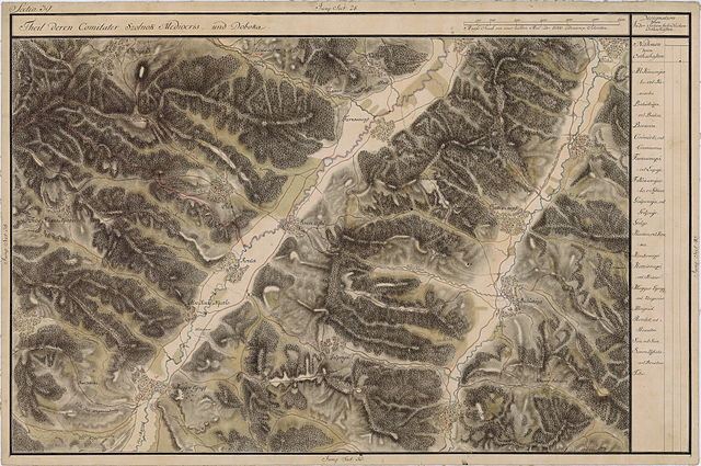
| Name shown on the map Nume din hartă |
Administrative unit Unitate administrativă |
Romanian name Numele românesc |
Hungarian name Numele unguresc |
German name Numele german |
Country today Ţara de astăzi |
|---|---|---|---|---|---|
| Moigrad | hu:Közép-Szolnok vármegye de:Komitat Szilágy ro:Comitatul Solnocul de Mijloc |
Moigrad | Mojgrád | Romania | |
| Felsö Kékes Nyarlo | Doboka megye Komitat Szolnok-Doboka Comitatul Dăbâca |
Stâna | Felsõnyárló | Romania | |
| Sák | Közép-Szolnok megye | Jac | Zsákfalva | Romania | |
| Somre Ujfalu | Doboka megye | Brusturi | Somróújfalu | Romania | |
| Farkasmezõ | Doboka megye | Lupoaia | Farkasmezõ | Romania | |
| Karika | Közép-Szolnok megye | Creaca | Karika | Romania | |
| Borsova | Doboka megye | Borza | Egregyborzova | Romania | |
| Kettosmezõ | Doboka megye | Chechiş | Kettõsmezõ | Romania | |
| Tiho | Doboka megye | Tihău | Tihó | Romania | |
| Gelgo | Doboka megye | Gâlgău Almaşului | Almásgalgó | Romania | |
| Balásháza | Doboka megye | Bălan | Almásbalázsháza | Romania | |
| Kendermezõ | Doboka megye | Chendrea | Kendermezõ | Romania | |
| Galponja | Doboka megye | Gălpâia | Galponya | Romania | |
| Romlot | Doboka megye | Romita | Romlott | Romania | |
| Also Kékes Nyarlo | Doboka megye | Chichişa | Alsónyárló | Romania | |
| Magyor Egregy | Doboka megye | Românaşi | Alsóegregy | Romania | |
| Csömörlõ | Doboka megye | Ciumărna | Csömörlõ | Romania |
Summary
[edit]
| Description |
English: Grand Duchy of Transylvania, 1769-1773. Josephinische Landaufnahme pg.039 Română: Harta Iosefină a Transilvaniei, 1769-1773. Josephinische Landaufnahme pg.039 |
||||
| Date | between 1769 and 1773 | ||||
| Source | Österreichisches Staatsarchiv, Kriegsarchiv, B IX 715: Original-Aufnahmskarte des Grossfürtenthums Siebenbürgen. Geometrisch aufgenommen und bearbeitet in den Jahren 1769 bis 1773 unter der Direction des Obristen von Fabris, theils durch Officiere des grossen Feld-Generalstabes, theils auch von verschiedenen aus dem in Siebenbürgen bequartierten Regimentern zu diesem Geschäfte beigezogenen Individuen | ||||
| Author | Historische Militärkarte der österreichisch-ungarischen Monarchie | ||||
| Permission (Reusing this file) |
|
||||
Clickable Map of the Grand Duchy of Transylvania
[edit]
File history
Click on a date/time to view the file as it appeared at that time.
| Date/Time | Thumbnail | Dimensions | User | Comment | |
|---|---|---|---|---|---|
| current | 23:09, 3 December 2009 | | 8,410 × 5,588 (26.03 MB) | Asybaris01 (talk | contribs) | good rezolution |
| 05:45, 22 October 2009 |  | 5,467 × 3,632 (17.37 MB) | Asybaris01 (talk | contribs) | {{Information |Description={{ro|1=Josephinische Landaufnahme pg39}} |Source=Josephinische Landaufnahme pg39 |Author=Asybaris01 |Date=2009/10/22 |Permission= |other_versions= }} |
You cannot overwrite this file.
File usage on Commons
The following 2 pages use this file:
File usage on other wikis
The following other wikis use this file:
- Usage on arz.wikipedia.org
- Usage on ca.wikipedia.org
- Usage on en.wikipedia.org
- Usage on eo.wikipedia.org
- Usage on fa.wikipedia.org
- Usage on hu.wikipedia.org
- Usage on ro.wikipedia.org
View more global usage of this file.