File:Josephinische Landaufnahme pg071.jpg
Jump to navigation
Jump to search

Size of this preview: 800 × 531 pixels. Other resolutions: 320 × 212 pixels | 640 × 425 pixels | 1,024 × 679 pixels | 1,280 × 849 pixels | 2,560 × 1,699 pixels | 8,948 × 5,937 pixels.
Original file (8,948 × 5,937 pixels, file size: 29.08 MB, MIME type: image/jpeg)
Captions
Captions
Add a one-line explanation of what this file represents
| Warning | The original file is very high-resolution. It might not load properly or could cause your browser to freeze when opened at full size. |
|---|
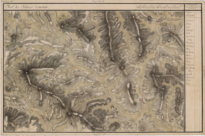
| Name shown on the map Nume din hartă |
Administrative unit Unitate administrativă |
Romanian name Numele românesc |
Hungarian name Numele unguresc |
German name Numele german |
Country today Ţara de astăzi |
|---|---|---|---|---|---|
| Egeres | Kolozs megye Komitat Klausenburg Comitatul Cluj |
Aghireşu | Egeres | Erldorf | Romania |
| Solyomtelke | Kolozs megye | Corneşti | Sólyomtelke | Romania | |
| Sz. Mihalytelke | Kolozs megye | Mihăieşti | Nádasszentmihály | Sankt Michael | Romania |
| Szomordok | Kolozs megye | Sumurducu | Szomordok | Romania | |
| Sz: Pál | Kolozs megye | Sânpaul | Magyarszentpál | Paulsdorf | Romania |
| Sárd | Kolozs megye | Şardu | Magyarsárd | Romania | |
| Füüre | Kolozs megye | Turea | Türe | Romania | |
| Bogártelke | Kolozs megye | Băgara | Bogártelke | Romania | |
| Dárocz | Kolozs megye | Dorolţu | Nádasdaróc | Draas | Romania |
| Inaktelke | Kolozs megye | Inucu | Inaktelke | Romania | |
| Mako | Kolozs megye | Macău | Mákófalva | Romania | |
| Gorbo | Kolozs megye | Gârbău | Magyargorbó | Romania | |
| Méra | Kolozs megye | Mera | Méra | Romania | |
| M. Nádas | Kolozs megye | Nădăşelu | Magyarnádas | Rohrfeld | Romania |
| Gezteragy | Kolozs megye | Straja | Gesztrágy | Gestren | Romania |
| Nagy Kapus | Kolozs megye | Căpuşu Mare | Magyarkapus | Grossthoren | Romania |
| Kis Kapus | Kolozs megye | Căpuşu Mic | Kiskapus | Kleinthoren | Romania |
| Vista | Kolozs megye | Viştea | Magyarvista | Romania |
Summary
[edit]
| Description |
English: Grand Duchy of Transylvania, 1769-1773. Josephinische Landaufnahme pg.071 Română: Harta Iosefină a Transilvaniei, 1769-1773. Josephinische Landaufnahme pg.071 |
||||
| Date | between 1769 and 1773 | ||||
| Source | Österreichisches Staatsarchiv, Kriegsarchiv, B IX 715: Original-Aufnahmskarte des Grossfürtenthums Siebenbürgen. Geometrisch aufgenommen und bearbeitet in den Jahren 1769 bis 1773 unter der Direction des Obristen von Fabris, theils durch Officiere des grossen Feld-Generalstabes, theils auch von verschiedenen aus dem in Siebenbürgen bequartierten Regimentern zu diesem Geschäfte beigezogenen Individuen | ||||
| Author | Historische Militärkarte der österreichisch-ungarischen Monarchie | ||||
| Permission (Reusing this file) |
|
||||
Clickable Map of the Grand Duchy of Transylvania
[edit]
File history
Click on a date/time to view the file as it appeared at that time.
| Date/Time | Thumbnail | Dimensions | User | Comment | |
|---|---|---|---|---|---|
| current | 09:50, 4 December 2009 | | 8,948 × 5,937 (29.08 MB) | Asybaris01 (talk | contribs) | good rezolution |
| 06:29, 23 October 2009 |  | 5,816 × 3,859 (19.28 MB) | Asybaris01 (talk | contribs) | {{Information |Description={{ro|1=Josephinische Landaufnahme pg71}} |Source=Josephinische Landaufnahme pg71 |Author=Asybaris01 |Date=2009/10/23 |Permission= |other_versions= }} |
You cannot overwrite this file.
File usage on Commons
The following 2 pages use this file:
File usage on other wikis
The following other wikis use this file:
- Usage on arz.wikipedia.org
- Usage on hu.wikipedia.org
- Usage on ro.wikipedia.org
- Comuna Căpușu Mare, Cluj
- Căpușu Mic, Cluj
- Straja (Căpușu Mare), Cluj
- Comuna Aghireșu, Cluj
- Băgara, Cluj
- Cornești (Gârbău), Cluj
- Dorolțu, Cluj
- Inucu, Cluj
- Macău, Cluj
- Mera, Cluj
- Mihăiești, Cluj
- Nădășelu, Cluj
- Comuna Sânpaul, Cluj
- Sumurducu, Cluj
- Șardu, Cluj
- Turea, Cluj
- Viștea, Cluj
- Gârbău, Cluj
- Căpușu Mare, Cluj
- Usage on tt.wikipedia.org
- Usage on www.wikidata.org