File:Karte Deutsch-Dänischer Krieg Militärereignisse.png
Jump to navigation
Jump to search

Size of this preview: 501 × 600 pixels. Other resolutions: 200 × 240 pixels | 401 × 480 pixels | 641 × 768 pixels | 855 × 1,024 pixels | 1,861 × 2,228 pixels.
Original file (1,861 × 2,228 pixels, file size: 708 KB, MIME type: image/png)
Captions
Captions
Add a one-line explanation of what this file represents
| Description |
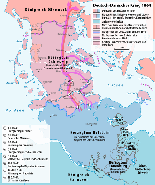
Deutsch: Karte der militärischen Ereignisse während und der Grenzänderungen durch den Deutsch-Dänischen Krieg
English: Map of the military events and of the boundary changes during the Second Schleswig War. Text in German. |
| Date | see file history |
| Source |
Own work, using |
| Author | Maximilian Dörrbecker (Chumwa) |
| Permission (Reusing this file) |
I, the copyright holder of this work, hereby publish it under the following license: This file is licensed under the Creative Commons Attribution-Share Alike 3.0 Unported license.
Sie dürfen das Bild zu den folgenden Bedingungen nutzen:
|
| Other versions |
|


|
This map has been made or improved in the German Kartenwerkstatt (Map Lab). You can propose maps to improve as well.
|
File history
Click on a date/time to view the file as it appeared at that time.
| Date/Time | Thumbnail | Dimensions | User | Comment | |
|---|---|---|---|---|---|
| current | 18:55, 20 February 2017 | | 1,861 × 2,228 (708 KB) | Chumwa (talk | contribs) | |
| 13:37, 24 December 2016 |  | 1,861 × 2,228 (709 KB) | Chumwa (talk | contribs) | ||
| 15:43, 23 December 2016 |  | 1,861 × 2,228 (710 KB) | Chumwa (talk | contribs) | ||
| 15:41, 23 December 2016 |  | 1,861 × 2,228 (710 KB) | Chumwa (talk | contribs) | ||
| 18:18, 21 July 2016 |  | 1,861 × 2,228 (718 KB) | Chumwa (talk | contribs) | ||
| 18:34, 26 April 2016 |  | 1,861 × 2,228 (717 KB) | Chumwa (talk | contribs) | ||
| 16:58, 26 April 2016 |  | 1,861 × 2,228 (716 KB) | Chumwa (talk | contribs) | ||
| 18:27, 25 April 2016 |  | 1,861 × 2,228 (713 KB) | Chumwa (talk | contribs) | ||
| 04:20, 8 April 2016 |  | 1,861 × 2,228 (763 KB) | Chumwa (talk | contribs) | ||
| 22:19, 6 April 2016 |  | 1,861 × 2,228 (763 KB) | Chumwa (talk | contribs) | {{Information |Description= {{de|Karte der militärischen Ereignisse während und der Grenzänderungen durch den Deutsch-Dänischen Krieg}} {{en|Map of the military events and of the boundary changes duringr the [[:en:... |
You cannot overwrite this file.
File usage on Commons
The following 2 pages use this file:
File usage on other wikis
The following other wikis use this file:
- Usage on azb.wikipedia.org
- Usage on de.wikipedia.org
- Usage on en.wikipedia.org
- Usage on eo.wikipedia.org
- Usage on es.wikipedia.org
- Usage on fr.wikipedia.org
- Usage on hu.wikipedia.org
- Usage on ja.wikipedia.org
- Usage on ka.wikipedia.org
- Usage on lt.wikipedia.org
- Usage on nn.wikipedia.org
- Usage on sv.wikipedia.org
- Usage on zh.wikipedia.org