File:Karte Deutsches Reich, Verwaltungsgliederung 1900-01-01.png
跳至導覽
跳至搜尋

預覽大小:452 × 600 像素。 其他解析度:181 × 240 像素 | 361 × 480 像素 | 578 × 768 像素 | 771 × 1,024 像素 | 1,543 × 2,048 像素 | 5,013 × 6,654 像素。
原始檔案 (5,013 × 6,654 像素,檔案大小:6 MB,MIME 類型:image/png)
說明
說明
添加單行說明來描述出檔案所代表的內容
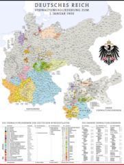
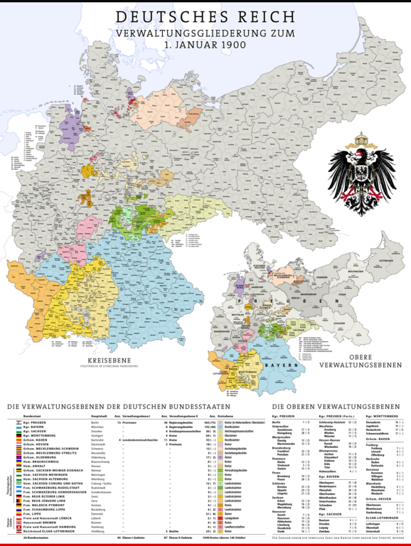
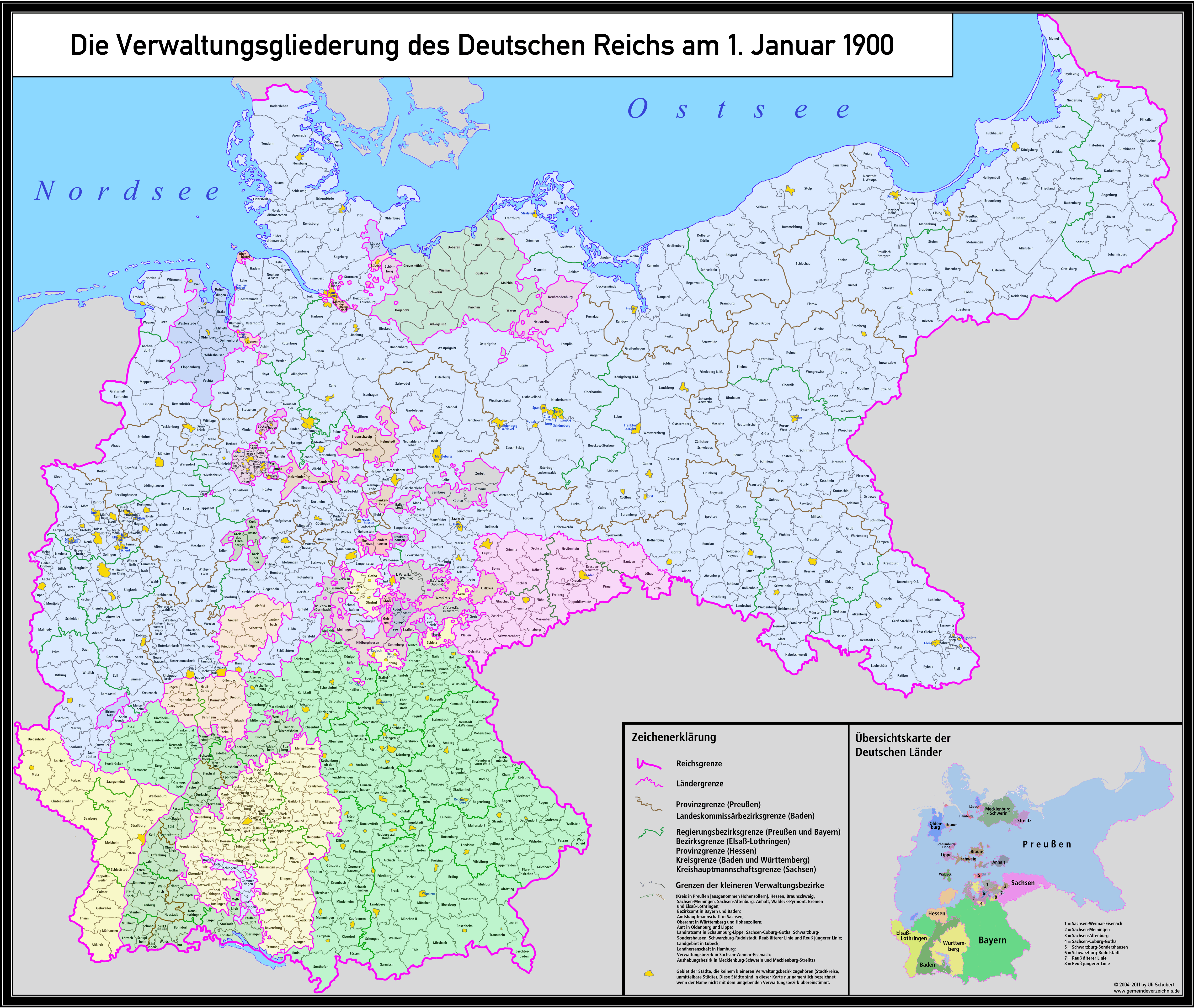
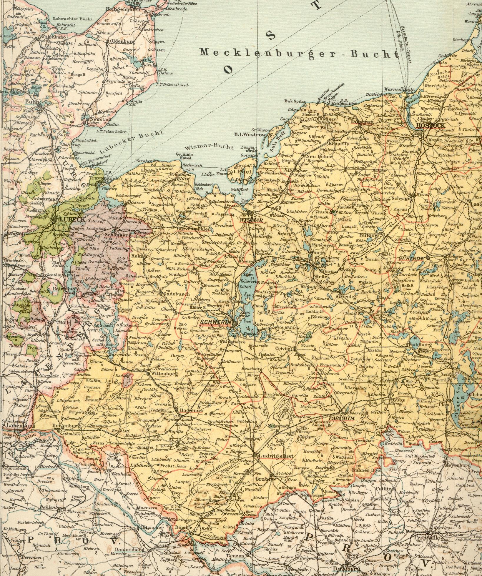
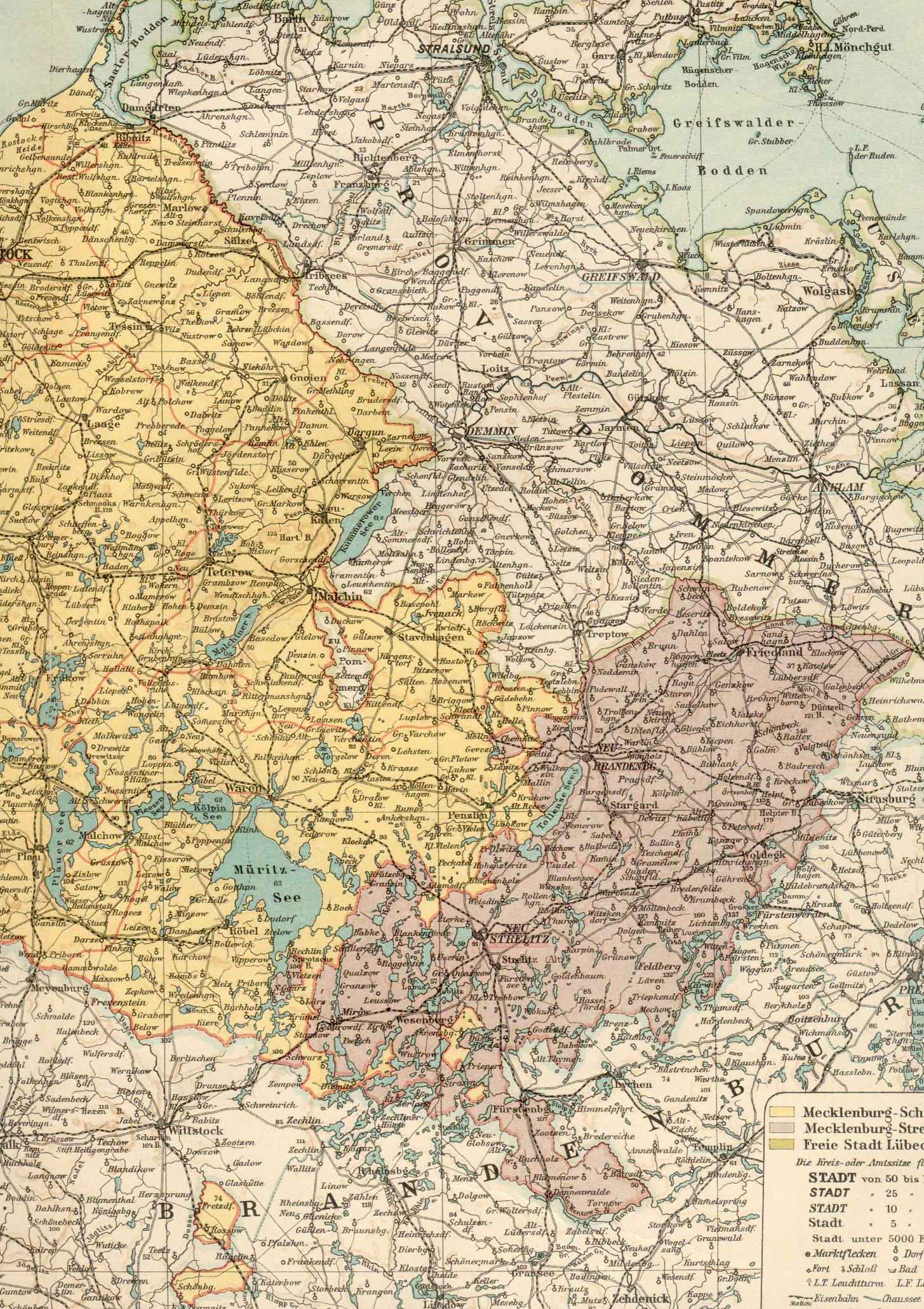
Administrative Map of the German Empire as of January 1st, 1900
摘要
[編輯]| 描述 |
Deutsch: Karte der Verwaltungsgliederung des Deutschen Reichs zum Stand 1. Januar 1900
English: Administrative Map of the German Empire as of January 1st, 1900 |
| 日期 | |
| 來源 |
自己的作品, using following data and information:
...and many more maps and information from diverse Wikipedia articles.
For the other coats of arms diverse elements of the following coat-of-arms-files:
|
| 作者 | Maximilian Dörrbecker (Chumwa) |
| 授權許可 (重用此檔案) |
此檔案採用共享創意 姓名標示-相同方式分享 2.0 通用版授權條款。
Sie dürfen das Bild zu den folgenden Bedingungen nutzen:
|
| 其他版本 |
|


.svg)
.jpg)
.svg)
.svg)
.svg)
.svg)
.svg)
.svg)
檔案歷史
點選日期/時間以檢視該時間的檔案版本。
| 日期/時間 | 縮圖 | 尺寸 | 用戶 | 備註 | |
|---|---|---|---|---|---|
| 目前 | 2024年3月8日 (五) 15:02 | | 5,013 × 6,654(6 MB) | Pilum2211(對話 | 貢獻) | Previous Pload error (?) |
| 2024年3月8日 (五) 15:01 |  | 5,013 × 6,654(3.33 MB) | Pilum2211(對話 | 貢獻) | Reverted to version as of 08:21, 20 April 2020 (UTC) | |
| 2024年3月8日 (五) 13:52 |  | 5,013 × 6,654(6 MB) | Pilum2211(對話 | 貢獻) | Added "Kreis Memel" to the "Regierungsbezirk Königsberg" | |
| 2020年4月20日 (一) 08:21 |  | 5,013 × 6,654(3.33 MB) | NordNordWest(對話 | 貢獻) | wider -> wieder | |
| 2019年8月9日 (五) 17:42 |  | 5,013 × 6,654(5.18 MB) | Chumwa(對話 | 貢獻) | corr | |
| 2019年2月5日 (二) 20:49 |  | 5,013 × 6,654(5.2 MB) | Chumwa(對話 | 貢獻) | Heiligenbein → Heiligenbeil | |
| 2017年8月15日 (二) 07:47 |  | 5,013 × 6,654(5.38 MB) | Chumwa(對話 | 貢獻) | Aurich war am 1.1.1900 ein eigener Regierungsbezirk in der preußischen Provinz Hannover | |
| 2017年5月10日 (三) 21:05 |  | 5,013 × 6,654(5.19 MB) | Chumwa(對話 | 貢獻) | Die Enklave im mecklenburg-schwerinschen Kreis Malchin gehört nicht zu Mecklenburg-Strelitz, sondern zur preussischen Provinz Pommern, Kreis Demmin. | |
| 2016年12月5日 (一) 10:49 |  | 5,013 × 6,654(5.49 MB) | Androl(對話 | 貢獻) | Neckars-ulm -> Neckar-sulm | |
| 2016年11月20日 (日) 20:42 |  | 5,013 × 6,654(5.19 MB) | Chumwa(對話 | 貢獻) | Beeskow-Strokow -> Beeskow-Storkow |
無法覆蓋此檔案。
檔案用途
下列7個頁面有用到此檔案:
- Old maps
- User:Chumwa/Gallery
- Commons:Featured picture candidates/File:Karte Deutsches Reich, Verwaltungsgliederung 1900-01-01.png
- Commons:Featured picture candidates/Log/July 2020
- File:Karte Deutsches Reich, Gliederung der oberen Verwaltungsebenen 1900-01-01.png
- File:Karte Deutsches Reich, Verwaltungsgliederung 1900-01-01.png
- File:Wappen und Flaggen des Deutschen Reichs und der Preußischen Provinzen.png
全域檔案使用狀況
以下其他 wiki 使用了這個檔案:
- af.wikipedia.org 的使用狀況
- als.wikipedia.org 的使用狀況
- an.wikipedia.org 的使用狀況
- ar.wikipedia.org 的使用狀況
- ast.wikipedia.org 的使用狀況
- azb.wikipedia.org 的使用狀況
- az.wikipedia.org 的使用狀況
- ba.wikipedia.org 的使用狀況
- be-tarask.wikipedia.org 的使用狀況
- be.wikipedia.org 的使用狀況
- bg.wikipedia.org 的使用狀況
- bn.wikipedia.org 的使用狀況
- br.wikipedia.org 的使用狀況
- ca.wikipedia.org 的使用狀況
- ckb.wikipedia.org 的使用狀況
- cs.wikipedia.org 的使用狀況
- da.wikipedia.org 的使用狀況
- de.wikipedia.org 的使用狀況
- Königreich Preußen
- Homburg
- Deutsches Kaiserreich
- Deutsche Reichsgründung
- Liste der Wappen in Deutschland
- Benutzer:Chumwa
- Liste der Landkreise Preußens
- Staatsleistungen
- Kreisordnung (Preußen)
- Geschichte der Kreisbildung in Deutschland
- Kreisreformen in Preußen
- Verwaltungsgliederung Preußens
- Benutzer Diskussion:Chumwa/Archiv/2015/3. Quartal
- Benutzer:Chumwa/SomeOfMyFiles
- Benutzer:Natus37/Preußen
- el.wikipedia.org 的使用狀況
- en.wikipedia.org 的使用狀況
- eo.wikipedia.org 的使用狀況
- es.wikipedia.org 的使用狀況
- et.wikipedia.org 的使用狀況
- eu.wikipedia.org 的使用狀況
- fi.wikipedia.org 的使用狀況
檢視此檔案的更多全域使用狀況。