File:Karte der Ukraine.png
Jump to navigation
Jump to search
Size of this preview: 800 × 538 pixels. Other resolutions: 320 × 215 pixels | 640 × 430 pixels | 1,024 × 688 pixels | 1,280 × 860 pixels | 2,560 × 1,720 pixels | 4,844 × 3,255 pixels.
Original file (4,844 × 3,255 pixels, file size: 2.88 MB, MIME type: image/png)
Captions
Captions
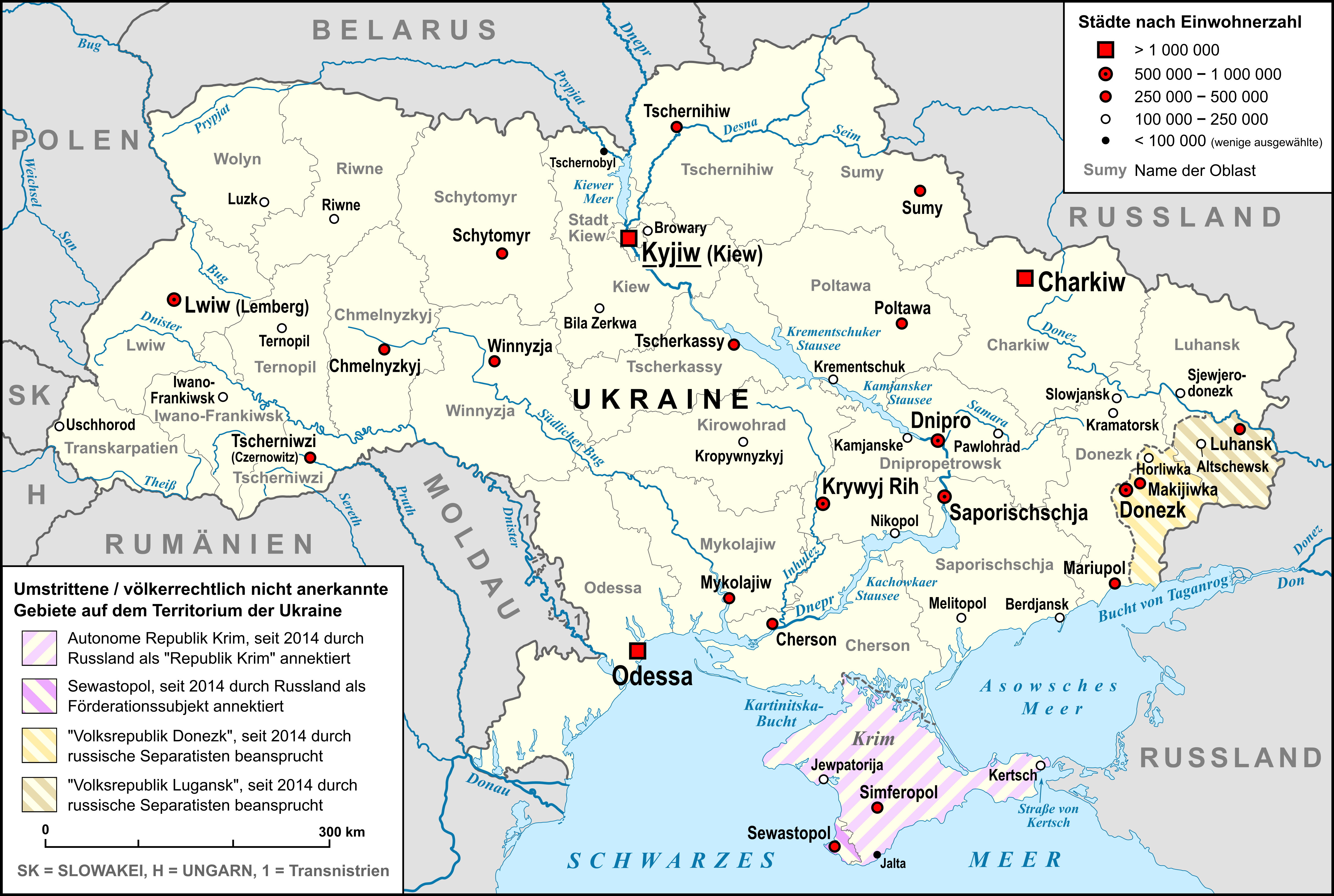
Map of Ukraine
Summary
[edit]
| Description |
Deutsch: Karte der Ukraine, mit Oblasten, größten Städten, Flüssen und Nachbarländern, sowie den umstrittenen Gebieten auf dem Territorium der Ukraine, "Republik Krim", "Volksrepublik Lugansk" und "Volksrepublik Donezk" |
| Date | |
| Source |
own work, used: |
| Author | Lencer |
| Other versions |
 |

|
This map has been made or improved in the German Kartenwerkstatt (Map Lab). You can propose maps to improve as well.
|
Licensing
[edit]
I, the copyright holder of this work, hereby publish it under the following license:
This file is licensed under the Creative Commons Attribution-Share Alike 3.0 Unported license.
- You are free:
- to share – to copy, distribute and transmit the work
- to remix – to adapt the work
- Under the following conditions:
- attribution – You must give appropriate credit, provide a link to the license, and indicate if changes were made. You may do so in any reasonable manner, but not in any way that suggests the licensor endorses you or your use.
- share alike – If you remix, transform, or build upon the material, you must distribute your contributions under the same or compatible license as the original.
File history
Click on a date/time to view the file as it appeared at that time.
| Date/Time | Thumbnail | Dimensions | User | Comment | |
|---|---|---|---|---|---|
| current | 05:35, 29 September 2022 | | 4,844 × 3,255 (2.88 MB) | Lencer (talk | contribs) | fix oblast Saporischschja |
| 11:28, 6 March 2022 |  | 4,844 × 3,255 (2.8 MB) | Lencer (talk | contribs) | + Schraffuren | |
| 05:03, 2 March 2022 |  | 4,844 × 3,255 (2.75 MB) | Lencer (talk | contribs) | small fix | |
| 20:45, 1 March 2022 |  | 4,844 × 3,255 (2.75 MB) | Lencer (talk | contribs) | small fix | |
| 20:31, 1 March 2022 |  | 4,844 × 3,255 (2.75 MB) | Lencer (talk | contribs) | Status Sewastopol herausgestellt | |
| 19:24, 1 March 2022 |  | 4,844 × 3,255 (2.71 MB) | Lencer (talk | contribs) | Small fix | |
| 18:28, 1 March 2022 |  | 4,844 × 3,255 (2.71 MB) | Lencer (talk | contribs) | Fix Fläche Sewastopol | |
| 20:55, 28 February 2022 |  | 4,844 × 3,255 (2.71 MB) | Lencer (talk | contribs) | == {{int:filedesc}} == {{Information |Description= {{de|Karte der Ukraine, mit Oblasten, größten Städten, Flüssen und Nachbarländern, sowie den umstrittenen Gebieten auf dem Territorium der Ukraine, "Republik Krim", "Volksrepublik Lugansk" und "Volksrepublik Donezk"}} |Source=own work, used: * Ukraine_adm_location_map.svg by User:NordNordWest * Ukraine_2022-02-21.svg by User:NordNordWest * [[:File:R... |
You cannot overwrite this file.
File usage on Commons
The following 7 pages use this file:
- User:Magog the Ogre/Maps of conflicts/2022 February
- User:Magog the Ogre/Maps of conflicts/2022 March
- User:Magog the Ogre/Maps of conflicts/2022 September
- User:Magog the Ogre/Multilingual legend/2022 February 19-28
- User:Magog the Ogre/Multilingual legend/2022 March 1-10
- User:Magog the Ogre/Multilingual legend/2022 September 21-30
- File:Map of Ukraine with Cities.png
File usage on other wikis
The following other wikis use this file:
- Usage on de.wikipedia.org
- Usage on frp.wikipedia.org