File:Keepers Lock near Fradley, Staffordshire - geograph.org.uk - 1567867.jpg
Jump to navigation
Jump to search
Size of this preview: 442 × 599 pixels. Other resolutions: 177 × 240 pixels | 472 × 640 pixels.
Original file (472 × 640 pixels, file size: 140 KB, MIME type: image/jpeg)
Captions
Captions
Add a one-line explanation of what this file represents
Summary
[edit]
| Description |
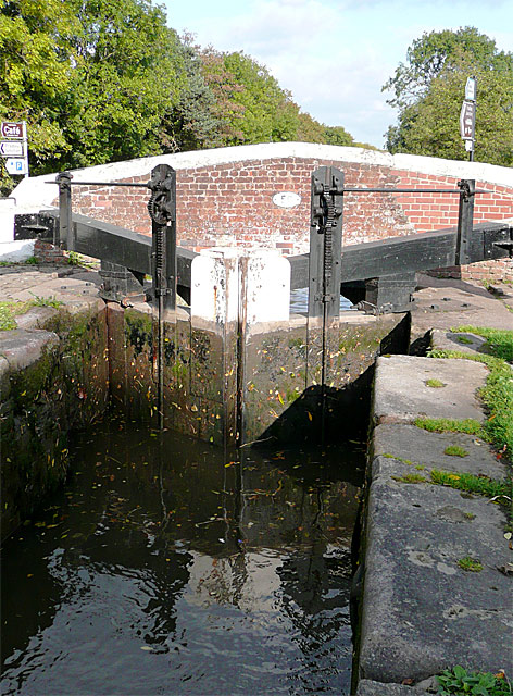
English: Keepers Lock near Fradley, Staffordshire. The lock alters the water level by 6ft 10in (about 2.1 metres) and is just over half full in the picture. There are five well spaced locks in the flight at Fradley. There are seventy-six on the whole Trent and Mersey Canal, which was built between 1766 and 1777, engineered by James Brindley. |
| Date | |
| Source | From geograph.org.uk |
| Author | Roger Kidd |
| Attribution (required by the license) | Roger Kidd / Keepers Lock near Fradley, Staffordshire / |
| Camera location | | View this and other nearby images on: OpenStreetMap |
|---|
_heading:45.00&language=en)
| Object location | | View this and other nearby images on: OpenStreetMap |
|---|
_heading:45.00&language=en)
Licensing
[edit]

|
This image was taken from the Geograph project collection. See this photograph's page on the Geograph website for the photographer's contact details. The copyright on this image is owned by Roger Kidd and is licensed for reuse under the Creative Commons Attribution-ShareAlike 2.0 license.
|
This file is licensed under the Creative Commons Attribution-Share Alike 2.0 Generic license.
Attribution: Roger Kidd
- You are free:
- to share – to copy, distribute and transmit the work
- to remix – to adapt the work
- Under the following conditions:
- attribution – You must give appropriate credit, provide a link to the license, and indicate if changes were made. You may do so in any reasonable manner, but not in any way that suggests the licensor endorses you or your use.
- share alike – If you remix, transform, or build upon the material, you must distribute your contributions under the same or compatible license as the original.
File history
Click on a date/time to view the file as it appeared at that time.
| Date/Time | Thumbnail | Dimensions | User | Comment | |
|---|---|---|---|---|---|
| current | 17:10, 3 March 2011 | | 472 × 640 (140 KB) | GeographBot (talk | contribs) | == {{int:filedesc}} == {{Information |description={{en|1=Keepers Lock near Fradley, Staffordshire The lock alters the water level by 6ft 10in (about 2.1 metres) and is just over half full in the picture. There are five well spaced locks in the flight at F |
You cannot overwrite this file.
File usage on Commons
There are no pages that use this file.