File:Khartoum, Sudan ESA350422.tiff

Original file (5,118 × 5,118 pixels, file size: 74.98 MB, MIME type: image/tiff)
Captions
Captions
Summary
[edit]| Description |
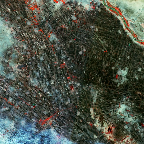
English: This false-colour image of south Khartoum in Sudan was one of the first from Sentinel-2A on 28 June, five days after it arrived in orbit.
The scene lies just south of the capital, the country’s second largest city. It sits between the White Nile River on the left (not visible) and the Blue Nile River on the right, which flows west from Ethiopia. The scene confirms that Sentinel-2 is doing the job it was designed for: monitoring vegetation. The mission tracks variability in land surface conditions, with its wide swath width and frequent revisits showing how vegetation changes during the growing season. The high-resolution multispectral instrument reveals the area’s agricultural condition. Part of the Blue Nile River is visible on the upper right corner. The scattered reds bordering the river denote the dense vegetation. In this arid part of the country, much of the agriculture is highly concentrated around the river. Along the Blue Nile, farming patterns recall French-style farms. Every agricultural plot is a distinctive rectangle, with some substantially longer than others. This geometric arrangement allows each plot to be irrigated. The main crops include sorghum, wheat, cotton, sunflower groundnuts, vegetables, fruit trees, and alfalfa. Sentinel-2A has been in orbit since 23 June. It is a high-resolution satellite for land monitoring, providing imagery of vegetation, soil and water cover, inland waterways and coastal areas. This image is featured on theEarth from Space video programme. |
| Date | |
| Source | http://www.esa.int/spaceinimages/Images/2015/11/Khartoum_Sudan |
| Author | European Space Agency |
| Permission (Reusing this file) |
Copernicus Sentinel data (2015)/ESA,CC BY-SA 3.0 IGO |
| Other versions |
|
| Title | Khartoum, Sudan |
| Set | Earth observation image of the week |
| System | Copernicus |
| Mission | Sentinel-2 |
| Location | Sudan |
| Activity | Observing the Earth |
| Keywords | Agriculture; Satellite image |

Licensing
[edit]- You are free:
- to share – to copy, distribute and transmit the work
- to remix – to adapt the work
- Under the following conditions:
- attribution – You must give appropriate credit, provide a link to the license, and indicate if changes were made. You may do so in any reasonable manner, but not in any way that suggests the licensor endorses you or your use.
- share alike – If you remix, transform, or build upon the material, you must distribute your contributions under the same or compatible license as the original.

|
This image contains data from a satellite in the Copernicus Programme, such as Sentinel-1, Sentinel-2 or Sentinel-3. Attribution is required when using this image.
Attribution: Contains modified Copernicus Sentinel data {{{year}}}
The use of Copernicus Sentinel Data is regulated under EU law (Commission Delegated Regulation (EU) No 1159/2013 and Regulation (EU) No 377/2014). Relevant excerpts:
Free access shall be given to GMES dedicated data [...] made available through GMES dissemination platforms [...].
Access to GMES dedicated data [...] shall be given for the purpose of the following use in so far as it is lawful:
GMES dedicated data [...] may be used worldwide without limitations in time.
GMES dedicated data and GMES service information are provided to users without any express or implied warranty, including as regards quality and suitability for any purpose. |
File history
Click on a date/time to view the file as it appeared at that time.
| Date/Time | Thumbnail | Dimensions | User | Comment | |
|---|---|---|---|---|---|
| current | 23:12, 7 May 2017 |  | 5,118 × 5,118 (74.98 MB) | Fæ (talk | contribs) | == {{int:filedesc}} == {{information | description = {{en|1=This false-colour image of south Khartoum in Sudan was one of the first from Sentinel-2A on 28 June, five days after it arrived in orbit. The scene lies just south of the capital, the country... |
You cannot overwrite this file.
File usage on Commons
The following page uses this file: