File:Kosovo map-en.svg
跳转到导航
跳转到搜索

此SVG文件的PNG预览的大小:582 × 599像素。 其他分辨率:233 × 240像素 | 466 × 480像素 | 746 × 768像素 | 994 × 1,024像素 | 1,989 × 2,048像素 | 1,777 × 1,830像素。
原始文件 (SVG文件,尺寸为1,777 × 1,830像素,文件大小:3.81 MB)
说明
说明
添加一行文字以描述该文件所表现的内容
摘要
[编辑]| 描写 |
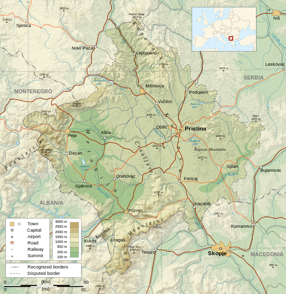
Čeština: Mapa Kosova. Dansk: Kort over Kosovo. Deutsch: Karte des Kosovo. English: Map of the Kosovo. Español: Mapa de Kosovo. Français : Carte du Kosovo, en anglais. Italiano: Mappa del Kosovo. Magyar: Koszovó térképe albán és szerb helységnevekkel. Polski: Mapa Kosowa. Română: Harta provinciei Kosovo Svenska: Karta över Kosovo, engelskspråkig. Türkçe: Kosova haritası. Македонски: Карта на Косово на англиски. Русский: Карта Косово, на английском. Українська: Карта Косово 日本語: コソボの地図。 |
||
| 日期 | |||
| 来源 |
Own work. Sources :
Software used :
Other data :
|
||
| 创作作者 | |||
| 地理参考 | 如果不适当,请设置 warp_status = skip 为隐藏。 | ||
| 其他版本 |
[] | ||
| 署名 (由许可协议要求) | © Sémhur / Wikimedia Commons / | ||
| Assessments | |||
| SVG | W3C-validity not checked.
|
||
| Graphic Lab |


| 相机位置 | | 在以下服务上查看本图像和附近其他图像: OpenStreetMap |
|---|
许可协议
[编辑]
我,本作品著作权人,特此采用以下许可协议发表本作品:
| 非营利著作权:本艺术作品是自由的,您可以依据自由艺术作品许可协议的条款传播和/或修改本艺术作品。您可以在Copyleft Attitude网站或其他网站找到该许可协议的样本。 |
This file is licensed under the Creative Commons Attribution-Share Alike Attribution-Share Alike 4.0 International, 3.0 Unported, 2.5 Generic, 2.0 Generic and 1.0 Generic license.
- 您可以自由地:
- 共享 – 复制、发行并传播本作品
- 修改 – 改编作品
- 惟须遵守下列条件:
- 署名 – 您必须对作品进行署名,提供授权条款的链接,并说明是否对原始内容进行了更改。您可以用任何合理的方式来署名,但不得以任何方式表明许可人认可您或您的使用。
- 相同方式共享 – 如果您再混合、转换或者基于本作品进行创作,您必须以与原先许可协议相同或相兼容的许可协议分发您贡献的作品。
您可以选择您需要的许可协议。
文件历史
点击某个日期/时间查看对应时刻的文件。
| 日期/时间 | 缩略图 | 大小 | 用户 | 备注 | |
|---|---|---|---|---|---|
| 当前 | 2023年9月21日 (四) 14:35 | | 1,777 × 1,830(3.81 MB) | Socialdilema(留言 | 贡献) | File uploaded using svgtranslate tool (https://svgtranslate.toolforge.org/). Added translation for ca. |
| 2021年5月12日 (三) 18:41 |  | 1,777 × 1,830(3.74 MB) | Uniacademic(留言 | 贡献) | Same as the previous edit. | |
| 2021年5月12日 (三) 18:28 |  | 1,777 × 1,830(3.74 MB) | Uniacademic(留言 | 贡献) | Updated the names of cities in cases where WP:COMMONNAME has changed since 2008. | |
| 2008年3月5日 (三) 09:14 |  | 1,777 × 1,830(3.75 MB) | Sémhur(留言 | 贡献) | Added borders, with keys (recognized - disputed) | |
| 2008年3月4日 (二) 09:16 |  | 1,777 × 1,830(3.74 MB) | Sémhur(留言 | 贡献) | Remove Kosovo boundaries to neutralize the map, + labels more readable | |
| 2008年3月3日 (一) 14:45 |  | 1,777 × 1,830(3.74 MB) | Sémhur(留言 | 贡献) | Correcting few labels | |
| 2008年2月28日 (四) 19:15 |  | 1,777 × 1,830(3.74 MB) | Sémhur(留言 | 贡献) | minor changes | |
| 2008年2月26日 (二) 11:37 |  | 1,777 × 1,830(3.74 MB) | Sémhur(留言 | 贡献) | == Description == {{Information |Description= {{en| Map of the Kosovo.}} {{fr| Carte du Kosovo, en anglais.}} |Source=Own work. {{clr}} Sources : * Topographic background : [http://www2.jpl.nasa.gov/srtm NASA Shuttle Radar To |
您不可以覆盖此文件。
文件用途
以下21个页面使用本文件:
- Atlas of Kosovo
- Wikimedia Conference Japan 2009/Commons写真展
- User:Giorgi Balakhadze/Gallery
- User:JoKalliauer/SVG test suites/Featured details
- User:Magog the Ogre/Multilingual legend/2021 May 11-20
- User:Magog the Ogre/Multilingual legend/2023 September 21-25
- User:Miya/Introduction
- User:Miya/POTY/Diagrams2008
- User talk:Sémhur/Archives/2007-2008
- Commons:Featured picture candidates/Image:Kosovo map-en.svg
- Commons:Featured picture candidates/Image:Kosovo map-en.svg 1
- Commons:Featured picture candidates/Log/March 2008
- Commons:Featured pictures/Non-photographic media/Maps
- Commons:Featured pictures/chronological/2008-A
- Commons:Picture of the Year/2008/Galleries/All
- Commons:Picture of the Year/2008/Galleries/Diagrams
- Commons:Picture of the Year/2008/Results/Round 1/Gallery/All
- Commons:Picture of the Year/2008/Results/Round 1/Gallery/Diagrams
- Commons:Picture of the Year 2008/File:Kosovo map-en.svg
- File:Kosovo map-cs.svg
- File:Republic of KOSOVO.png(文件重定向)
全域文件用途
以下其他wiki使用此文件:
- af.wikipedia.org上的用途
- ar.wikipedia.org上的用途
- az.wikipedia.org上的用途
- bcl.wikipedia.org上的用途
- be-tarask.wikipedia.org上的用途
- bg.wikipedia.org上的用途
- de.wikipedia.org上的用途
- de.wikibooks.org上的用途
- en.wikipedia.org上的用途
- es.wikipedia.org上的用途
- fa.wikipedia.org上的用途
- fi.wikipedia.org上的用途
- fr.wikipedia.org上的用途
- fr.wikinews.org上的用途
- ga.wikipedia.org上的用途
- gl.wikipedia.org上的用途
- gv.wikipedia.org上的用途
- hy.wikipedia.org上的用途
- is.wikipedia.org上的用途
- ko.wikipedia.org上的用途
- lt.wikipedia.org上的用途
- mg.wikipedia.org上的用途
- ml.wikipedia.org上的用途
- mr.wikipedia.org上的用途
- mzn.wikipedia.org上的用途
- nn.wikipedia.org上的用途
- no.wikipedia.org上的用途
查看此文件的更多全域用途。