File:L'école d'architecture (Nantes) (9304278276).jpg
Jump to navigation
Jump to search

Size of this preview: 800 × 534 pixels. Other resolutions: 320 × 214 pixels | 640 × 427 pixels | 1,024 × 684 pixels | 1,513 × 1,010 pixels.
Original file (1,513 × 1,010 pixels, file size: 989 KB, MIME type: image/jpeg)
Captions
Captions
Add a one-line explanation of what this file represents
Summary[edit]
_(9304278276).jpg&action=edit§ion=1)
| Description |
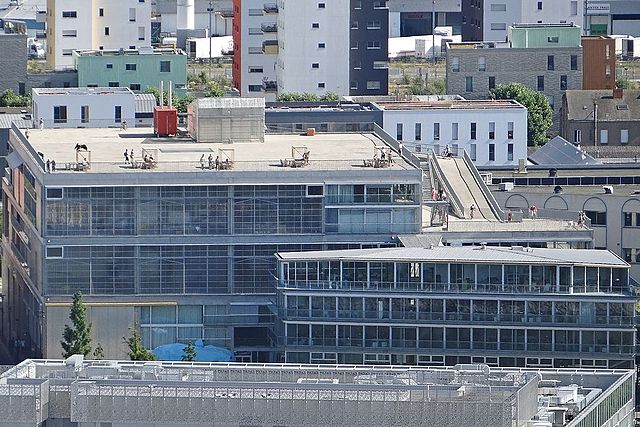
L'école d'architecture a été conçue par les architectes Anne Lacaton et Jean-Philippe Vassal le bâtiment, livré en 2009, est situé quai François Mitterrand. Le bâtiment principal est desservi par une rampe extérieure en pente douce. Elle permet au public d'accéder à la terrasse et durant le Voyage à Nantes, de voir des installations d'artistes. Le petit bâtiment est relié au bâtiment principal par une passerelle couverte. Au rez-de-chaussée, il dispose d'une salle d'exposition. |
| Date | |
| Source | L'école d'architecture (Nantes) |
| Author | Jean-Pierre Dalbéra from Paris, France |
| Camera location | | View this and other nearby images on: OpenStreetMap |
|---|
_(9304278276).jpg¶ms=047.207305_N_-001.557025_E_globe:Earth_type:camera_source:Flickr_&language=en)
Licensing[edit]
_(9304278276).jpg&action=edit§ion=2)
This file is licensed under the Creative Commons Attribution 2.0 Generic license.
- You are free:
- to share – to copy, distribute and transmit the work
- to remix – to adapt the work
- Under the following conditions:
- attribution – You must give appropriate credit, provide a link to the license, and indicate if changes were made. You may do so in any reasonable manner, but not in any way that suggests the licensor endorses you or your use.
| This image was originally posted to Flickr by dalbera at https://www.flickr.com/photos/72746018@N00/9304278276. It was reviewed on 9 December 2014 by FlickreviewR and was confirmed to be licensed under the terms of the cc-by-2.0. |
File history
Click on a date/time to view the file as it appeared at that time.
| Date/Time | Thumbnail | Dimensions | User | Comment | |
|---|---|---|---|---|---|
| current | 13:59, 15 December 2014 | | 1,513 × 1,010 (989 KB) | Lomita (talk | contribs) | Suppression cadre |
| 16:05, 9 December 2014 |  | 1,536 × 1,024 (1.29 MB) | Medium69 (talk | contribs) | Transferred from Flickr via Flickr2Commons |
You cannot overwrite this file.
File usage
There are no pages that use this file.
Global file usage
The following other wikis use this file:
- Usage on en.wikipedia.org
- Usage on es.wikipedia.org
- Usage on eu.wikipedia.org
- Usage on fa.wikipedia.org
- Usage on gl.wikipedia.org
- Usage on id.wikipedia.org
- Usage on kk.wikipedia.org
- Usage on ko.wikipedia.org
- Usage on mk.wikipedia.org
- Usage on pl.wikipedia.org
- Usage on pt.wikipedia.org
- Usage on sv.wikipedia.org
- Usage on uk.wikipedia.org
- Usage on www.wikidata.org
- Usage on zh.wikipedia.org
_(9304278276).jpg&oldid=752743194)