File:LAX Terminal Diagram.svg
Jump to navigation
Jump to search

Size of this PNG preview of this SVG file: 512 × 316 pixels. Other resolutions: 320 × 198 pixels | 640 × 395 pixels | 1,024 × 632 pixels | 1,280 × 790 pixels | 2,560 × 1,580 pixels.
Original file (SVG file, nominally 512 × 316 pixels, file size: 22 KB)
Captions
Captions
Add a one-line explanation of what this file represents
Summary[edit]
| Description |
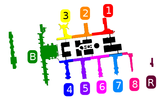
English: Map of terminals, boarding areas, and runways at Los Angeles International Airport (LAX). Simplified vector shapes extracted from FAA source PDF and colors added.
|
| Date | |
| Source | https://www.faa.gov/air_traffic/flight_info/aeronav/digital_products/dtpp/search/ |
| Author | Federal Aviation Administration |
| SVG development | This W3C-invalid diagram was created with Inkscape…important. This diagram uses embedded text that can be easily translated using a text editor. |
Licensing[edit]
This image or file is a work of a Federal Aviation Administration employee, taken or made as part of that person's official duties. As a work of the U.S. federal government, the image is in the public domain in the United States.
|
 |
File history
Click on a date/time to view the file as it appeared at that time.
| Date/Time | Thumbnail | Dimensions | User | Comment | |
|---|---|---|---|---|---|
| current | 01:45, 10 February 2023 | | 512 × 316 (22 KB) | RickyCourtney (talk | contribs) | Redo showing Terminal 1.5, West B Gates and Regional terminal |
| 17:35, 16 August 2017 |  | 180 × 150 (110 KB) | Mliu92 (talk | contribs) | User created page with UploadWizard |
You cannot overwrite this file.
File usage on Commons
The following 5 pages use this file:
File usage on other wikis
The following other wikis use this file:
- Usage on ast.wikipedia.org
- Usage on en.wikipedia.org
- Usage on es.wikipedia.org
- Usage on ja.wikipedia.org
- Usage on nl.wikipedia.org
- Usage on zh.wikipedia.org