File:Le royaume des Francs sous Hugues Capet-ka.svg
ნავიგაციაზე გადასვლა
ძიებაზე გადასვლა

ამ SVG ფაილის PNG წინასწარი გადახედვის ზომაა: 598 × 599 პიქსელი. სხვა გაფართოება: 239 × 240 პიქსელი | 479 × 480 პიქსელი | 766 × 768 პიქსელი | 1 022 × 1 024 პიქსელი | 2 043 × 2 048 პიქსელი | 1 796 × 1 800 პიქსელი.
თავდაპირველი ფაილი (ფაილი SVG, ნომინალურად 1 796 × 1 800 პიქსელი, ფაილის ზომა: 1,23 მბ)
Captions
Captions
Add a one-line explanation of what this file represents
რეზიუმე[რედაქტირება]
| აღწერა |
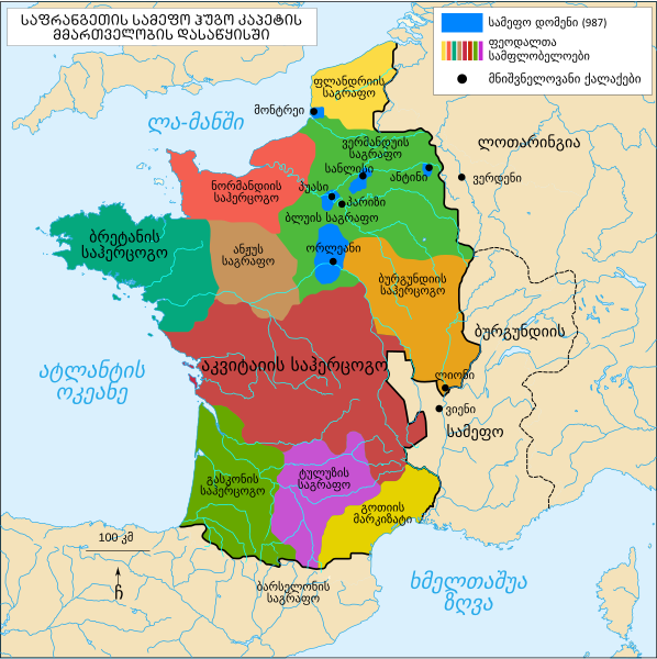
ქართული: საფრანგეთის სამეფო ჰუგო კაპეტის მეფობის დასაწყისში |
| თარიღი | |
| წყარო | File:Le royaume des Francs sous Hugues Capet-fr.svg |
| ავტორი | Bourrichon (original), გიორგი ოქროპირიძე (translate) |
ლიცენზია[რედაქტირება]
მე, ამ ნაწარმოებზე საავტორო უფლებების მფლობელი, საკუთარი სურვილით ვაქვეყნებ მას შემდეგი ლიცენზიით:

|
თქვენ შეგიძიათ გაავრცელოთ ან შეცვალოთ დოკუმენტი GNU Free Documentation ლიცენზიის 1.2 ან უფრო გვიანდელი ვერსიის პირობების თანახმად, რომელიც გამოქვეყნებულია თავისუფალი პროგრამული უზრუნველყოფის ფონდის მიერ, შეუცვლელი განყოფილებების გარეშე, პირველ და ბოლო გვერდებზე განთავსებულ ტექსტებზე. ლიცენზიის ასლი არის განთავსებული განყოფილებაში სახელად GNU Free Documentation License. |
ეს ნამუშევარი ვრცელდება Creative Commons Attribution-Share Alike 3.0 Unported, 2.5 Generic, 2.0 Generic და 1.0 Generic ლიცენზიით.
- თქვენ თავისუფლად შეგიძლიათ:
- ნამუშევრის გაზიარება – ნამუშევრის კოპირება, გავრცელება და გადაცემა.
- შექმნათ დაფუძნებულები – ნამუშევრის შესწორება
- შემდეგი პირობებით:
- მოხსენიება – თქვენ უნდა მიუთითოთ წყაროს შემქმნელი იმ გზით, რომელიც დანიშნა ავტორმა ან საავტორო უფლებების მფლობელმა. მაგრამ არა ისე, თითქოს წყაროს ავტორი მხარს გიჭერთ თქვენ ან დაუჭირა თქვენს მიერ შექმნილ ნაწარმოებს.
- გავრცელება იგივე პირობებეით – თუ თქვენ ცვლით, ან ქმნით ახალ ნაშრომს ამ ნამუშევრის გამოყენებთ, თქვენ გაქვთ უფლება გაავრცელოთ იგი იგივე ან შესაბამისი ლიცენზიით, რომლითაც ვრცელდება წყარო.
თქვენ შეგიძლიათ აირჩიოთ ლიცენზია.
ფაილის ისტორია
დააწკაპუნეთ თარიღზე/დროზე, რათა იხილოთ ფაილი, როგორც ის მაშინ გამოიყურებოდა.
| თარიღი/დრო | მინიატიურა | განზომილებები | მომხმარებელი | კომენტარი | |
|---|---|---|---|---|---|
| მიმდინარე | 17:42, 28 მაისი 2019 | | 1 796 × 1 800 (1,23 მბ) | Giorgi Balakhadze (განხილვა | წვლილი) | fix 2 |
| 09:52, 27 მაისი 2019 |  | 1 796 × 1 800 (1,11 მბ) | გიო ოქრო (განხილვა | წვლილი) | fix | |
| 09:46, 27 მაისი 2019 |  | 1 796 × 1 800 (1,11 მბ) | გიო ოქრო (განხილვა | წვლილი) | User created page with UploadWizard |
თქვენ არ შეგიძლიათ ამ ფაილზე გადაწერა.
ფაილის გამოყენება
ეს ფაილი არცერთ გვერდზე არ გამოიყენება.
ფაილის გლობალური გამოყენება
ეს ფაილი გამოიყენება შემდეგ ვიკებში:
- გამოყენება ka.wikipedia.org-ში
მეტამონაცემები
კატეგორიები:
- SVG maps of the history of France
- Maps showing 10th-century history
- Maps of the kingdom of France
- Maps of 10th-century France
- SVG maps of historical provinces of France
- Duchy of Normandy
- Duchy of Brittany
- Duchy of Aquitaine
- Duchy of Burgundy
- County of Anjou
- Maps of the county of Flanders
- Kingdom of Burgundy
- County of Toulouse