File:Light tower and corner of keeper's house, view northeast, northwest and southwest sides - Baker Island Light, Lightkeeper's House, Just east of Cranberry Isles, at entrance to HABS ME,5-BAKIS,1-5.tif
Jump to navigation
Jump to search

Size of this JPG preview of this TIF file: 481 × 599 pixels. Other resolutions: 192 × 240 pixels | 385 × 480 pixels | 616 × 768 pixels | 822 × 1,024 pixels | 1,643 × 2,048 pixels | 4,012 × 5,000 pixels.
Original file (4,012 × 5,000 pixels, file size: 19.13 MB, MIME type: image/tiff)
Captions
Captions
Add a one-line explanation of what this file represents
Summary[edit]
| Light tower and corner of keeper's house, view northeast, northwest and southwest sides - Baker Island Light, Lightkeeper's House, Just east of Cranberry Isles, at entrance to Frenchman Bay, Bar Harbor, Hancock County, ME | ||||
|---|---|---|---|---|
| Photographer |
Related names:
|
|||
| Title |
Light tower and corner of keeper's house, view northeast, northwest and southwest sides - Baker Island Light, Lightkeeper's House, Just east of Cranberry Isles, at entrance to Frenchman Bay, Bar Harbor, Hancock County, ME |
|||
| Depicted place | Maine; Hancock County; Bar Harbor | |||
| Date | Documentation compiled after 1933 | |||
| Dimensions | 4 x 5 in. | |||
| Current location |
Library of Congress Prints and Photographs Division Washington, D.C. 20540 USA http://hdl.loc.gov/loc.pnp/pp.print |
|||
| Accession number |
HABS ME,5-BAKIS,1-5 |
|||
| Credit line |
|
|||
| Notes |
|
|||
| Source | http://lcweb2.loc.gov/master/pnp/habshaer/me/me0000/me0038/photos/338671pu.tif | |||
| Permission (Reusing this file) |
|
|||

| Object location | | View this and other nearby images on: OpenStreetMap |
|---|
File history
Click on a date/time to view the file as it appeared at that time.
| Date/Time | Thumbnail | Dimensions | User | Comment | |
|---|---|---|---|---|---|
| current | 23:06, 28 July 2014 | 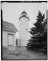 | 4,012 × 5,000 (19.13 MB) | Fæ (talk | contribs) | GWToolset: Creating mediafile for Fæ. HABS 21 July 2014 (1601:1800) |
You cannot overwrite this file.
File usage on Commons
The following page uses this file: