File:Localisation EPCI Angers Loire Métropole en Maine-et-Loire, France.svg
Jump to navigation
Jump to search

Size of this PNG preview of this SVG file: 767 × 600 pixels. Other resolutions: 307 × 240 pixels | 614 × 480 pixels | 982 × 768 pixels | 1,280 × 1,001 pixels | 2,560 × 2,002 pixels | 1,197 × 936 pixels.
Original file (SVG file, nominally 1,197 × 936 pixels, file size: 6.36 MB)
Captions
Captions
Add a one-line explanation of what this file represents
Summary[edit]
| Description |
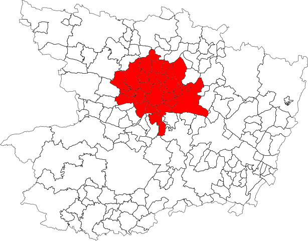
Français : Localisation de la Communauté urbaine Angers Loire Métropole dans le département de Maine-et-Loire. Composition au 1er janvier 2016. |
| Date | |
| Source | Own work, à partir de File:Blank Map of Maine-et-Loire Department, France, with Communes.svg. |
| Author | Carte d'origine : Poulpy (talk · contribs) |
Licensing[edit]
This file is licensed under the Creative Commons Attribution-Share Alike 3.0 Unported license.
- You are free:
- to share – to copy, distribute and transmit the work
- to remix – to adapt the work
- Under the following conditions:
- attribution – You must give appropriate credit, provide a link to the license, and indicate if changes were made. You may do so in any reasonable manner, but not in any way that suggests the licensor endorses you or your use.
- share alike – If you remix, transform, or build upon the material, you must distribute your contributions under the same or compatible license as the original.
File history
Click on a date/time to view the file as it appeared at that time.
| Date/Time | Thumbnail | Dimensions | User | Comment | |
|---|---|---|---|---|---|
| current | 15:49, 12 May 2019 | | 1,197 × 936 (6.36 MB) | Petit Angevin (talk | contribs) | Fichier plus propre |
| 18:38, 20 July 2018 |  | 1,000 × 780 (274 KB) | Sancta floris (talk | contribs) | Communes on 01/01/2018 (rectified). | |
| 15:28, 14 July 2018 |  | 1,000 × 780 (175 KB) | Sancta floris (talk | contribs) | Update (new communes on 1/1/2018) | |
| 20:18, 24 January 2016 |  | 1,000 × 780 (160 KB) | Pymouss (talk | contribs) | Update (new communes on 1/1/2016) | |
| 15:33, 3 September 2013 |  | 1,000 × 780 (168 KB) | Auxerroisdu68 (talk | contribs) | User created page with UploadWizard |
You cannot overwrite this file.
File usage on Commons
The following page uses this file:
File usage on other wikis
The following other wikis use this file:
- Usage on en.wikipedia.org
- Usage on fr.wikipedia.org
- Usage on www.wikidata.org