File:Loch Doon (Loch an Pheidlar) - geograph.org.uk - 219680.jpg
Jump to navigation
Jump to search
No higher resolution available.
Loch_Doon_(Loch_an_Pheidlar)_-_geograph.org.uk_-_219680.jpg (450 × 600 pixels, file size: 101 KB, MIME type: image/jpeg)
Captions
Captions
Add a one-line explanation of what this file represents
Summary
[edit]_-_geograph.org.uk_-_219680.jpg&action=edit§ion=1)
| Description |
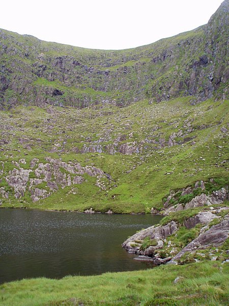
English: Loch Doon (Loch an Pheidlar) The eastern edge of Pedlar's Lake (also known as Loch Doon) in a corrie with a 200 metre tall headwall behind. This corrie is quite unusual in the Brendan mountain range as it faces west. The majority of corries in the area face north and east where the microclimate was more conducive to the accumulation of ice during the last glaciation some 10,000+ years ago. |
| Date | |
| Source | From geograph.org.uk |
| Author | Sharon Loxton |
| Attribution (required by the license) | Sharon Loxton / Loch Doon (Loch an Pheidlar) / |
| Object location | | View this and other nearby images on: OpenStreetMap |
|---|
_-_geograph.org.uk_-_219680.jpg¶ms=052.185500_N_-010.187000_E_globe:Earth_class:object_type:object_source:geograph-irishgrid(Q504059)_heading:90.00&language=en)
Licensing
[edit]_-_geograph.org.uk_-_219680.jpg&action=edit§ion=2)

|
This image was taken from the Geograph project collection. See this photograph's page on the Geograph website for the photographer's contact details. The copyright on this image is owned by Sharon Loxton and is licensed for reuse under the Creative Commons Attribution-ShareAlike 2.0 license.
|
This file is licensed under the Creative Commons Attribution-Share Alike 2.0 Generic license.
Attribution: Sharon Loxton
- You are free:
- to share – to copy, distribute and transmit the work
- to remix – to adapt the work
- Under the following conditions:
- attribution – You must give appropriate credit, provide a link to the license, and indicate if changes were made. You may do so in any reasonable manner, but not in any way that suggests the licensor endorses you or your use.
- share alike – If you remix, transform, or build upon the material, you must distribute your contributions under the same or compatible license as the original.
File history
Click on a date/time to view the file as it appeared at that time.
| Date/Time | Thumbnail | Dimensions | User | Comment | |
|---|---|---|---|---|---|
| current | 22:50, 31 January 2010 | | 450 × 600 (101 KB) | GeographBot (talk | contribs) | == {{int:filedesc}} == {{Information |description={{en|1=Loch Doon (Loch an Pheidlar) The eastern edge of Pedlar's Lake (also known as Loch Doon) in a corrie with a 200 metre tall headwall behind. This corrie is quite unusual in the Brendan mountain range |
You cannot overwrite this file.
File usage on Commons
There are no pages that use this file.
File usage on other wikis
The following other wikis use this file:
- Usage on de.wikipedia.org
_-_geograph.org.uk_-_219680.jpg&oldid=937460417)