File:Lodelinsart - cour Dejean - plan Popp 1865.png
Jump to navigation
Jump to search

Size of this preview: 600 × 600 pixels. Other resolutions: 240 × 240 pixels | 620 × 620 pixels.
Original file (620 × 620 pixels, file size: 511 KB, MIME type: image/png)
Captions
Captions
Add a one-line explanation of what this file represents
Summary[edit]
| Description |
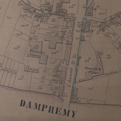
Français : Lodelinsart ( Charleroi-Belgique) - Localisation de la verrerie, actuellement cour Dejean, vers 1865. Extrait de l'atlas cadastral parcellaire de la Belgique, plus connu sous le nom de Plans Popp. |
| Date | |
| Source | Bibliothèque royale de Belgique |
| Author | Philippe Popp (1805-1879) |
| Camera location | | View this and other nearby images on: OpenStreetMap |
|---|
Licensing[edit]
|
This work is in the public domain in its country of origin and other countries and areas where the copyright term is the author's life plus 100 years or fewer. | |
| This file has been identified as being free of known restrictions under copyright law, including all related and neighboring rights. | |
File history
Click on a date/time to view the file as it appeared at that time.
| Date/Time | Thumbnail | Dimensions | User | Comment | |
|---|---|---|---|---|---|
| current | 13:38, 9 July 2011 | | 620 × 620 (511 KB) | Jmh2o (talk | contribs) |
You cannot overwrite this file.
File usage on Commons
The following page uses this file:
File usage on other wikis
The following other wikis use this file:
- Usage on fr.wikipedia.org
- Usage on www.wikidata.org