File:London Underground Overground DLR Crossrail map.svg
Salta a la navegació
Salta a la cerca

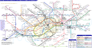
Mida d'aquesta previsualització PNG del fitxer SVG: 800 × 422 píxels. Altres resolucions: 320 × 169 píxels | 640 × 338 píxels | 1.024 × 541 píxels | 1.280 × 676 píxels | 2.560 × 1.352 píxels | 2.500 × 1.320 píxels.
Fitxer original (Fitxer SVG animat, nominalment 2.500 × 1.320 píxels, mida del fitxer: 219 Ko)
Nota: per limitacions tècniques no s'animaran les miniatures per aquest fitxer.
Llegendes
Llegendes
Afegeix una explicació d'una línia del que representa aquest fitxer
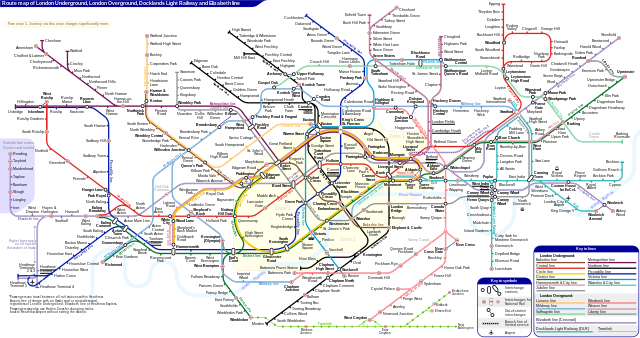
Schematic route map of London Underground, London Overground, Docklands Light Railway and Elizabeth line
Resum
[modifica]| Descripció |
English: *Route map of London Underground, London Overground, Docklands Light Railway and Elizabeth line (Crossrail), including most green-lighted proposals.
|
|||
| Data | ||||
| Font | Treball propi | |||
| Autor | Sameboat | |||
| Permís (Com reutilitzar aquest fitxer) |
Jo, el titular dels drets d'autor d'aquest treball, el public sota la següent llicència: This file is licensed under the Creative Commons Attribution-Share Alike 4.0 International license.
|
|||
| Altres versions |
|
|||
| SVG genesis | Aquesta imatge vectorial ha estat creada amb unknown tool This icon uses embedded text that can be easily translated using a text editor. |


|
Aquest és un fitxer SVG animat que utilitza SMIL. La previsualització PNG de més amunt creada amb librsvg no és animada i pot ser incompleta o incorrecta. Per veure bé l'animació obriu media:London Underground Overground DLR Crossrail map.svg amb un navegador o visualitzador que admeti animacions SVG, com Opera (8+), Safari (4+), Chrome (2+) o Internet Explorer amb Adobe SVG viewer instal·lat. Firefox do admet SMIL fins a la versió 3.5. Es poden trobar altres animacions SVG a Category:Animated SVG files.
|

Historial del fitxer
Cliqueu una data/hora per veure el fitxer tal com era aleshores.
| Data/hora | Miniatura | Dimensions | Usuari/a | Comentari | |
|---|---|---|---|---|---|
| actual | 06:27, 25 març 2024 | | 2.500 × 1.320 (219 Ko) | Sameboat (discussió | contribucions) | change OOC icon to NR |
| 06:22, 23 març 2024 |  | 2.500 × 1.320 (219 Ko) | Sameboat (discussió | contribucions) | restore changes made by The wub and Jc86035 | |
| 06:17, 23 març 2024 |  | 2.500 × 1.320 (219 Ko) | Sameboat (discussió | contribucions) | + Old Oak Common | |
| 23:16, 19 març 2024 |  | 2.500 × 1.320 (219 Ko) | The wub (discussió | contribucions) | Update cable car, add tooltip for Woolwich/Woolwich Arsenal interchange | |
| 21:54, 19 feb 2024 |  | 2.500 × 1.320 (219 Ko) | Jc86035 (discussió | contribucions) | Wandsworth Road | |
| 01:09, 19 feb 2024 |  | 2.500 × 1.320 (219 Ko) | Sameboat (discussió | contribucions) | ||
| 14:42, 16 feb 2024 |  | 2.500 × 1.320 (219 Ko) | Sameboat (discussió | contribucions) | ||
| 14:37, 16 feb 2024 |  | 2.500 × 1.320 (219 Ko) | Sameboat (discussió | contribucions) | overground new names and new colors | |
| 06:03, 7 nov 2022 |  | 2.500 × 1.320 (221 Ko) | Sameboat (discussió | contribucions) | Pudding Mill Lane portal | |
| 05:19, 6 nov 2022 |  | 2.500 × 1.320 (224 Ko) | Sameboat (discussió | contribucions) | Elizabeth line thru Paddington |
No podeu sobreescriure aquest fitxer.
Ús del fitxer
Hi ha més de 100 pàgines que utilitzen aquest fitxer. La següent llista només mostra les primeres 100 d'aquestes pàgines que utilitzen aquest fitxer. Podeu consultar la llista completa.
- London Underground
- London Underground stations M-Z
- Transit maps
- User:Chumwa/OgreBot/Potential transport maps/2016 February 1-9
- User:Chumwa/OgreBot/Potential transport maps/2016 January 21-31
- User:Chumwa/OgreBot/Potential transport maps/2016 July 21-31
- User:Chumwa/OgreBot/Potential transport maps/2016 June 11-20
- User:Chumwa/OgreBot/Potential transport maps/2016 March 21-31
- User:Chumwa/OgreBot/Potential transport maps/2016 November 21-30
- User:Chumwa/OgreBot/Public transport information/2015 April 1-10
- User:Chumwa/OgreBot/Public transport information/2015 April 21-30
- User:Chumwa/OgreBot/Public transport information/2015 August 21-31
- User:Chumwa/OgreBot/Public transport information/2015 December 21-31
- User:Chumwa/OgreBot/Public transport information/2015 February 19-28
- User:Chumwa/OgreBot/Public transport information/2015 July 1-10
- User:Chumwa/OgreBot/Public transport information/2015 July 21-31
- User:Chumwa/OgreBot/Public transport information/2015 June 1-10
- User:Chumwa/OgreBot/Public transport information/2015 June 11-20
- User:Chumwa/OgreBot/Public transport information/2015 June 21-30
- User:Chumwa/OgreBot/Public transport information/2015 March 1-10
- User:Chumwa/OgreBot/Public transport information/2015 March 11-20
- User:Chumwa/OgreBot/Public transport information/2015 March 21-31
- User:Chumwa/OgreBot/Public transport information/2015 May 11-20
- User:Chumwa/OgreBot/Public transport information/2015 May 21-31
- User:Chumwa/OgreBot/Public transport information/2015 October 1-10
- User:Chumwa/OgreBot/Public transport information/2015 October 21-31
- User:Chumwa/OgreBot/Public transport information/2015 September 1-10
- User:Chumwa/OgreBot/Public transport information/2015 September 11-20
- User:Chumwa/OgreBot/Public transport information/2016 February 1-9
- User:Chumwa/OgreBot/Public transport information/2016 January 1-10
- User:Chumwa/OgreBot/Public transport information/2016 January 21-31
- User:Chumwa/OgreBot/Public transport information/2016 July 21-31
- User:Chumwa/OgreBot/Public transport information/2016 June 11-20
- User:Chumwa/OgreBot/Public transport information/2016 March 21-31
- User:Chumwa/OgreBot/Public transport information/2016 November 21-30
- User:Chumwa/OgreBot/Transport Maps/2015 April 1-10
- User:Chumwa/OgreBot/Transport Maps/2015 April 21-30
- User:Chumwa/OgreBot/Transport Maps/2015 August 21-31
- User:Chumwa/OgreBot/Transport Maps/2015 December 21-31
- User:Chumwa/OgreBot/Transport Maps/2015 February 19-28
- User:Chumwa/OgreBot/Transport Maps/2015 July 1-10
- User:Chumwa/OgreBot/Transport Maps/2015 July 21-31
- User:Chumwa/OgreBot/Transport Maps/2015 June 1-10
- User:Chumwa/OgreBot/Transport Maps/2015 June 11-20
- User:Chumwa/OgreBot/Transport Maps/2015 June 21-30
- User:Chumwa/OgreBot/Transport Maps/2015 March 1-10
- User:Chumwa/OgreBot/Transport Maps/2015 March 11-20
- User:Chumwa/OgreBot/Transport Maps/2015 March 21-31
- User:Chumwa/OgreBot/Transport Maps/2015 May 11-20
- User:Chumwa/OgreBot/Transport Maps/2015 May 21-31
- User:Chumwa/OgreBot/Transport Maps/2015 October 1-10
- User:Chumwa/OgreBot/Transport Maps/2015 October 21-31
- User:Chumwa/OgreBot/Transport Maps/2015 September 1-10
- User:Chumwa/OgreBot/Transport Maps/2015 September 11-20
- User:Chumwa/OgreBot/Transport Maps/2016 February 1-9
- User:Chumwa/OgreBot/Transport Maps/2016 January 1-10
- User:Chumwa/OgreBot/Transport Maps/2016 January 21-31
- User:Chumwa/OgreBot/Transport Maps/2016 July 21-31
- User:Chumwa/OgreBot/Transport Maps/2016 June 11-20
- User:Chumwa/OgreBot/Transport Maps/2016 March 21-31
- User:Chumwa/OgreBot/Transport Maps/2016 November 21-30
- User:Chumwa/OgreBot/Transport Maps/2017 January 1-10
- User:Chumwa/OgreBot/Travel and communication maps/2016 February 1-9
- User:Chumwa/OgreBot/Travel and communication maps/2016 January 21-31
- User:Chumwa/OgreBot/Travel and communication maps/2016 July 21-31
- User:Chumwa/OgreBot/Travel and communication maps/2016 June 11-20
- User:Chumwa/OgreBot/Travel and communication maps/2016 March 21-31
- User:Chumwa/OgreBot/Travel and communication maps/2016 November 21-30
- User:Liesel/Rail transport/2015 February 19-28
- User:Liesel/Rail transport/2015 March 1-10
- User:Mattbuck/Railways/2014 August 11-20
- User:Mattbuck/Railways/2015 April 1-10
- User:Mattbuck/Railways/2015 April 21-30
- User:Mattbuck/Railways/2015 August 21-31
- User:Mattbuck/Railways/2015 December 21-31
- User:Mattbuck/Railways/2015 February 19-28
- User:Mattbuck/Railways/2015 July 1-10
- User:Mattbuck/Railways/2015 July 21-31
- User:Mattbuck/Railways/2015 June 1-10
- User:Mattbuck/Railways/2015 June 11-20
- User:Mattbuck/Railways/2015 June 21-30
- User:Mattbuck/Railways/2015 March 1-10
- User:Mattbuck/Railways/2015 March 11-20
- User:Mattbuck/Railways/2015 March 21-31
- User:Mattbuck/Railways/2015 May 11-20
- User:Mattbuck/Railways/2015 May 21-31
- User:Mattbuck/Railways/2015 October 1-10
- User:Mattbuck/Railways/2015 October 21-31
- User:Mattbuck/Railways/2015 September 1-10
- User:Mattbuck/Railways/2015 September 11-20
- User:Mattbuck/Railways/2016 February 1-9
- User:Mattbuck/Railways/2016 January 1-10
- User:Mattbuck/Railways/2016 January 21-31
- User:Mattbuck/Railways/2016 July 21-31
- User:Mattbuck/Railways/2016 June 11-20
- User:Mattbuck/Railways/2016 March 21-31
- User:Mattbuck/Railways/2016 November 21-30
- User:Mattbuck/Railways/2017 January 1-10
- User:Sameboat
- File:London Underground Overground DLR Crossrail map.pdf
Visualitza més enllaços que porten al fitxer.
Ús global del fitxer
Utilització d'aquest fitxer en altres wikis:
- Utilització a af.wikipedia.org
- Utilització a ar.wikipedia.org
- Utilització a ca.wikipedia.org
- Utilització a de.wikipedia.org
- Utilització a en.wikipedia.org
- Tube map
- Transport for London
- Schematic
- List of London Underground stations
- London Rail
- Wikipedia:Wikipedia Signpost/2015-06-03/In the media
- Wikipedia:Wikipedia Signpost/Single/2015-06-03
- User:Bellowhead678/sandbox
- Elizabeth line
- User:RogerNiceEyes/sandbox
- Talk:Elizabeth line
- Glossary of geography terms (N–Z)
- Utilització a en.wikivoyage.org
- Utilització a es.wikipedia.org
- Utilització a es.wikivoyage.org
- Utilització a fa.wikipedia.org
- Utilització a fi.wikipedia.org
- Utilització a fr.wikipedia.org
- Liste des stations du métro de Londres
- Woodside Park (métro de Londres)
- Gare de Moorgate
- High Barnet (métro de Londres)
- Totteridge & Whetstone (métro de Londres)
- Morden (métro de Londres)
- Burnt Oak (métro de Londres)
- West Finchley (métro de Londres)
- Brent Cross (métro de Londres)
- Golders Green (métro de Londres)
- Kensal Green (métro de Londres)
- Queen's Park (métro de Londres)
- Finchley Central (métro de Londres)
- Colliers Wood (métro de Londres)
- Mill Hill East (métro de Londres)
- Edgware (métro de Londres)
- Balham (métro de Londres)
- Barking (métro de Londres)
- Colindale (métro de Londres)
- Hendon Central (métro de Londres)
- Kilburn Park (métro de Londres)
Vegeu més usos globals d'aquest fitxer.