File:London Underground Overground DLR Crossrail map.svg
跳去導覽
跳去搵嘢

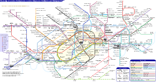
呢個「SVG」檔案嘅呢個「PNG」預覽嘅大細:800 × 422 像素。 第啲解像度:320 × 169 像素 | 640 × 338 像素 | 1,024 × 541 像素 | 1,280 × 676 像素 | 2,560 × 1,352 像素 | 2,500 × 1,320 像素。
原本檔案 (動態SVG檔案,表面大細: 2,500 × 1,320 像素,檔案大細:219 KB)
注意:因為技術限制,呢個檔案縮圖唔係動態。
Captions
Captions
Add a one-line explanation of what this file represents
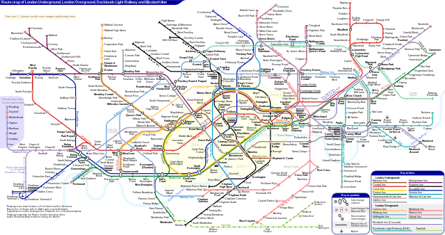
Schematic route map of London Underground, London Overground, Docklands Light Railway and Elizabeth line
摘要[編輯]
| 描述 |
English: *Route map of London Underground, London Overground, Docklands Light Railway and Elizabeth line (Crossrail), including most green-lighted proposals.
|
|||
| 日期 | ||||
| 來源 | 自己作品 | |||
| 作者 | Sameboat | |||
| 許可 (重用呢個檔案) |
我,呢份作品嘅作者,決定用以下許可發佈呢件作品: This file is licensed under the Creative Commons Attribution-Share Alike 4.0 International license.
|
|||
| Other versions |
|
|||
| SVG genesis | This icon was created with unknown tool. This icon uses embedded text that can be easily translated using a text editor. |


|
This image is an animated SVG file. The .png preview above created by RSVG for use in Wikimedia is not animated and may be incomplete or incorrect. To see the animation, open media:London Underground Overground DLR Crossrail map.svg. It should run in any modern browser or viewer. Recent versions of Chrome, Firefox, Microsoft Edge, Safari, and Opera all support SVG animated with SMIL.
Other SVG animations can be found at Category:Animated SVG files.
|

檔案歷史
撳個日期/時間去睇響嗰個時間出現過嘅檔案。
| 日期/時間 | 縮圖 | 尺寸 | 用戶 | 註解 | |
|---|---|---|---|---|---|
| 現時 | 2024年3月25號 (一) 06:27 | | 2,500 × 1,320(219 KB) | Sameboat(傾偈 | 貢獻) | change OOC icon to NR |
| 2024年3月23號 (六) 06:22 |  | 2,500 × 1,320(219 KB) | Sameboat(傾偈 | 貢獻) | restore changes made by The wub and Jc86035 | |
| 2024年3月23號 (六) 06:17 |  | 2,500 × 1,320(219 KB) | Sameboat(傾偈 | 貢獻) | + Old Oak Common | |
| 2024年3月19號 (二) 23:16 |  | 2,500 × 1,320(219 KB) | The wub(傾偈 | 貢獻) | Update cable car, add tooltip for Woolwich/Woolwich Arsenal interchange | |
| 2024年2月19號 (一) 21:54 |  | 2,500 × 1,320(219 KB) | Jc86035(傾偈 | 貢獻) | Wandsworth Road | |
| 2024年2月19號 (一) 01:09 |  | 2,500 × 1,320(219 KB) | Sameboat(傾偈 | 貢獻) | ||
| 2024年2月16號 (五) 14:42 |  | 2,500 × 1,320(219 KB) | Sameboat(傾偈 | 貢獻) | ||
| 2024年2月16號 (五) 14:37 |  | 2,500 × 1,320(219 KB) | Sameboat(傾偈 | 貢獻) | overground new names and new colors | |
| 2022年11月7號 (一) 06:03 |  | 2,500 × 1,320(221 KB) | Sameboat(傾偈 | 貢獻) | Pudding Mill Lane portal | |
| 2022年11月6號 (日) 05:19 |  | 2,500 × 1,320(224 KB) | Sameboat(傾偈 | 貢獻) | Elizabeth line thru Paddington |
你無得衾咗個檔案。
檔案用途
多過100版用到呢個檔。 下面嘅表只係列示咗用到呢個檔案嘅最頭100版。 一個完整嘅一覽喺度。
- London Underground
- London Underground stations M-Z
- Transit maps
- User:Chumwa/OgreBot/Potential transport maps/2016 February 1-9
- User:Chumwa/OgreBot/Potential transport maps/2016 January 21-31
- User:Chumwa/OgreBot/Potential transport maps/2016 July 21-31
- User:Chumwa/OgreBot/Potential transport maps/2016 June 11-20
- User:Chumwa/OgreBot/Potential transport maps/2016 March 21-31
- User:Chumwa/OgreBot/Potential transport maps/2016 November 21-30
- User:Chumwa/OgreBot/Public transport information/2015 April 1-10
- User:Chumwa/OgreBot/Public transport information/2015 April 21-30
- User:Chumwa/OgreBot/Public transport information/2015 August 21-31
- User:Chumwa/OgreBot/Public transport information/2015 December 21-31
- User:Chumwa/OgreBot/Public transport information/2015 February 19-28
- User:Chumwa/OgreBot/Public transport information/2015 July 1-10
- User:Chumwa/OgreBot/Public transport information/2015 July 21-31
- User:Chumwa/OgreBot/Public transport information/2015 June 1-10
- User:Chumwa/OgreBot/Public transport information/2015 June 11-20
- User:Chumwa/OgreBot/Public transport information/2015 June 21-30
- User:Chumwa/OgreBot/Public transport information/2015 March 1-10
- User:Chumwa/OgreBot/Public transport information/2015 March 11-20
- User:Chumwa/OgreBot/Public transport information/2015 March 21-31
- User:Chumwa/OgreBot/Public transport information/2015 May 11-20
- User:Chumwa/OgreBot/Public transport information/2015 May 21-31
- User:Chumwa/OgreBot/Public transport information/2015 October 1-10
- User:Chumwa/OgreBot/Public transport information/2015 October 21-31
- User:Chumwa/OgreBot/Public transport information/2015 September 1-10
- User:Chumwa/OgreBot/Public transport information/2015 September 11-20
- User:Chumwa/OgreBot/Public transport information/2016 February 1-9
- User:Chumwa/OgreBot/Public transport information/2016 January 1-10
- User:Chumwa/OgreBot/Public transport information/2016 January 21-31
- User:Chumwa/OgreBot/Public transport information/2016 July 21-31
- User:Chumwa/OgreBot/Public transport information/2016 June 11-20
- User:Chumwa/OgreBot/Public transport information/2016 March 21-31
- User:Chumwa/OgreBot/Public transport information/2016 November 21-30
- User:Chumwa/OgreBot/Transport Maps/2015 April 1-10
- User:Chumwa/OgreBot/Transport Maps/2015 April 21-30
- User:Chumwa/OgreBot/Transport Maps/2015 August 21-31
- User:Chumwa/OgreBot/Transport Maps/2015 December 21-31
- User:Chumwa/OgreBot/Transport Maps/2015 February 19-28
- User:Chumwa/OgreBot/Transport Maps/2015 July 1-10
- User:Chumwa/OgreBot/Transport Maps/2015 July 21-31
- User:Chumwa/OgreBot/Transport Maps/2015 June 1-10
- User:Chumwa/OgreBot/Transport Maps/2015 June 11-20
- User:Chumwa/OgreBot/Transport Maps/2015 June 21-30
- User:Chumwa/OgreBot/Transport Maps/2015 March 1-10
- User:Chumwa/OgreBot/Transport Maps/2015 March 11-20
- User:Chumwa/OgreBot/Transport Maps/2015 March 21-31
- User:Chumwa/OgreBot/Transport Maps/2015 May 11-20
- User:Chumwa/OgreBot/Transport Maps/2015 May 21-31
- User:Chumwa/OgreBot/Transport Maps/2015 October 1-10
- User:Chumwa/OgreBot/Transport Maps/2015 October 21-31
- User:Chumwa/OgreBot/Transport Maps/2015 September 1-10
- User:Chumwa/OgreBot/Transport Maps/2015 September 11-20
- User:Chumwa/OgreBot/Transport Maps/2016 February 1-9
- User:Chumwa/OgreBot/Transport Maps/2016 January 1-10
- User:Chumwa/OgreBot/Transport Maps/2016 January 21-31
- User:Chumwa/OgreBot/Transport Maps/2016 July 21-31
- User:Chumwa/OgreBot/Transport Maps/2016 June 11-20
- User:Chumwa/OgreBot/Transport Maps/2016 March 21-31
- User:Chumwa/OgreBot/Transport Maps/2016 November 21-30
- User:Chumwa/OgreBot/Transport Maps/2017 January 1-10
- User:Chumwa/OgreBot/Travel and communication maps/2016 February 1-9
- User:Chumwa/OgreBot/Travel and communication maps/2016 January 21-31
- User:Chumwa/OgreBot/Travel and communication maps/2016 July 21-31
- User:Chumwa/OgreBot/Travel and communication maps/2016 June 11-20
- User:Chumwa/OgreBot/Travel and communication maps/2016 March 21-31
- User:Chumwa/OgreBot/Travel and communication maps/2016 November 21-30
- User:Liesel/Rail transport/2015 February 19-28
- User:Liesel/Rail transport/2015 March 1-10
- User:Mattbuck/Railways/2014 August 11-20
- User:Mattbuck/Railways/2015 April 1-10
- User:Mattbuck/Railways/2015 April 21-30
- User:Mattbuck/Railways/2015 August 21-31
- User:Mattbuck/Railways/2015 December 21-31
- User:Mattbuck/Railways/2015 February 19-28
- User:Mattbuck/Railways/2015 July 1-10
- User:Mattbuck/Railways/2015 July 21-31
- User:Mattbuck/Railways/2015 June 1-10
- User:Mattbuck/Railways/2015 June 11-20
- User:Mattbuck/Railways/2015 June 21-30
- User:Mattbuck/Railways/2015 March 1-10
- User:Mattbuck/Railways/2015 March 11-20
- User:Mattbuck/Railways/2015 March 21-31
- User:Mattbuck/Railways/2015 May 11-20
- User:Mattbuck/Railways/2015 May 21-31
- User:Mattbuck/Railways/2015 October 1-10
- User:Mattbuck/Railways/2015 October 21-31
- User:Mattbuck/Railways/2015 September 1-10
- User:Mattbuck/Railways/2015 September 11-20
- User:Mattbuck/Railways/2016 February 1-9
- User:Mattbuck/Railways/2016 January 1-10
- User:Mattbuck/Railways/2016 January 21-31
- User:Mattbuck/Railways/2016 July 21-31
- User:Mattbuck/Railways/2016 June 11-20
- User:Mattbuck/Railways/2016 March 21-31
- User:Mattbuck/Railways/2016 November 21-30
- User:Mattbuck/Railways/2017 January 1-10
- User:Sameboat
- File:London Underground Overground DLR Crossrail map.pdf
去睇連到呢個檔案嘅更多連結。
全域檔案使用情況
下面嘅維基都用緊呢個檔案:
- af.wikipedia.org嘅使用情況
- ar.wikipedia.org嘅使用情況
- ca.wikipedia.org嘅使用情況
- de.wikipedia.org嘅使用情況
- en.wikipedia.org嘅使用情況
- Tube map
- Transport for London
- Schematic
- List of London Underground stations
- London Rail
- Wikipedia:Wikipedia Signpost/2015-06-03/In the media
- Wikipedia:Wikipedia Signpost/Single/2015-06-03
- User:Bellowhead678/sandbox
- Elizabeth line
- User:RogerNiceEyes/sandbox
- Talk:Elizabeth line
- Glossary of geography terms (N–Z)
- en.wikivoyage.org嘅使用情況
- es.wikipedia.org嘅使用情況
- es.wikivoyage.org嘅使用情況
- fa.wikipedia.org嘅使用情況
- fi.wikipedia.org嘅使用情況
- fr.wikipedia.org嘅使用情況
- Liste des stations du métro de Londres
- Woodside Park (métro de Londres)
- Gare de Moorgate
- High Barnet (métro de Londres)
- Totteridge & Whetstone (métro de Londres)
- Morden (métro de Londres)
- Burnt Oak (métro de Londres)
- West Finchley (métro de Londres)
- Brent Cross (métro de Londres)
- Golders Green (métro de Londres)
- Kensal Green (métro de Londres)
- Queen's Park (métro de Londres)
- Finchley Central (métro de Londres)
- Colliers Wood (métro de Londres)
- Mill Hill East (métro de Londres)
- Edgware (métro de Londres)
- Balham (métro de Londres)
- Barking (métro de Londres)
- Colindale (métro de Londres)
- Hendon Central (métro de Londres)
- Kilburn Park (métro de Londres)
睇呢個檔案嘅更多全域使用情況。