File:London Underground Overground DLR Crossrail map.svg
跳至導覽
跳至搜尋

此 SVG 檔案的 PNG 預覽的大小:800 × 422 像素。 其他解析度:320 × 169 像素 | 640 × 338 像素 | 1,024 × 541 像素 | 1,280 × 676 像素 | 2,560 × 1,352 像素 | 2,500 × 1,320 像素。
原始檔案 (SVG 動畫檔案,表面大小:2,500 × 1,320 像素,檔案大小:219 KB)
注意:由於技術限制,此檔案縮圖無動畫效果。
說明
說明
添加單行說明來描述出檔案所代表的內容
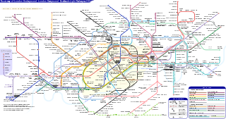
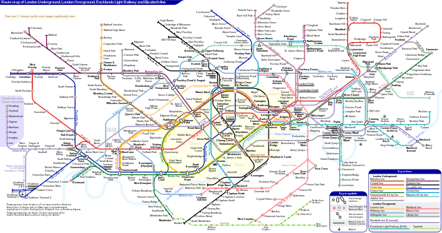
倫敦地下鐵、倫敦地上鐡、碼頭區輕鐡和伊利沙伯綫路綫圖
摘要
[編輯]| 描述 |
English: *Route map of London Underground, London Overground, Docklands Light Railway and Elizabeth line (Crossrail), including most green-lighted proposals.
|
|||
| 日期 | ||||
| 來源 | 自己的作品 | |||
| 作者 | Sameboat | |||
| 授權許可 (重用此檔案) |
我,本作品的著作權持有者,決定用以下授權條款發佈本作品: 此檔案採用共享創意 姓名標示-相同方式分享 4.0 國際授權條款。
|
|||
| 其他版本 |
|
|||
| SVG開發 |


|
本圖像是一個SVG動畫。本動畫使用SMIL語言。RSVG建立的,用於維基媒體網站的.png預覽圖像不能顯示動畫,而且圖像可能會殘缺不全或出現錯誤。要看到動畫,請開啟media:London Underground Overground DLR Crossrail map.svg。這應該在現代瀏覽器或閱覽器中工作。最新版本的Chrome、Firefox、Microsoft Edge、Safari及Opera均支援基於SMIL的SVG動畫。
其他SVG動畫檔案可在Category:Animated SVG files找到。
|

檔案歷史
點選日期/時間以檢視該時間的檔案版本。
| 日期/時間 | 縮圖 | 尺寸 | 用戶 | 備註 | |
|---|---|---|---|---|---|
| 目前 | 2024年3月25日 (一) 06:27 | | 2,500 × 1,320(219 KB) | Sameboat(對話 | 貢獻) | change OOC icon to NR |
| 2024年3月23日 (六) 06:22 |  | 2,500 × 1,320(219 KB) | Sameboat(對話 | 貢獻) | restore changes made by The wub and Jc86035 | |
| 2024年3月23日 (六) 06:17 |  | 2,500 × 1,320(219 KB) | Sameboat(對話 | 貢獻) | + Old Oak Common | |
| 2024年3月19日 (二) 23:16 |  | 2,500 × 1,320(219 KB) | The wub(對話 | 貢獻) | Update cable car, add tooltip for Woolwich/Woolwich Arsenal interchange | |
| 2024年2月19日 (一) 21:54 |  | 2,500 × 1,320(219 KB) | Jc86035(對話 | 貢獻) | Wandsworth Road | |
| 2024年2月19日 (一) 01:09 |  | 2,500 × 1,320(219 KB) | Sameboat(對話 | 貢獻) | ||
| 2024年2月16日 (五) 14:42 |  | 2,500 × 1,320(219 KB) | Sameboat(對話 | 貢獻) | ||
| 2024年2月16日 (五) 14:37 |  | 2,500 × 1,320(219 KB) | Sameboat(對話 | 貢獻) | overground new names and new colors | |
| 2022年11月7日 (一) 06:03 |  | 2,500 × 1,320(221 KB) | Sameboat(對話 | 貢獻) | Pudding Mill Lane portal | |
| 2022年11月6日 (日) 05:19 |  | 2,500 × 1,320(224 KB) | Sameboat(對話 | 貢獻) | Elizabeth line thru Paddington |
無法覆蓋此檔案。
檔案用途
超過 100 個頁面有用到此檔案。 下列清單只列出前 100 筆有用到此檔案的頁面。 您也可以檢視完整清單。
- London Underground
- London Underground stations M-Z
- Transit maps
- User:Chumwa/OgreBot/Potential transport maps/2016 February 1-9
- User:Chumwa/OgreBot/Potential transport maps/2016 January 21-31
- User:Chumwa/OgreBot/Potential transport maps/2016 July 21-31
- User:Chumwa/OgreBot/Potential transport maps/2016 June 11-20
- User:Chumwa/OgreBot/Potential transport maps/2016 March 21-31
- User:Chumwa/OgreBot/Potential transport maps/2016 November 21-30
- User:Chumwa/OgreBot/Public transport information/2015 April 1-10
- User:Chumwa/OgreBot/Public transport information/2015 April 21-30
- User:Chumwa/OgreBot/Public transport information/2015 August 21-31
- User:Chumwa/OgreBot/Public transport information/2015 December 21-31
- User:Chumwa/OgreBot/Public transport information/2015 February 19-28
- User:Chumwa/OgreBot/Public transport information/2015 July 1-10
- User:Chumwa/OgreBot/Public transport information/2015 July 21-31
- User:Chumwa/OgreBot/Public transport information/2015 June 1-10
- User:Chumwa/OgreBot/Public transport information/2015 June 11-20
- User:Chumwa/OgreBot/Public transport information/2015 June 21-30
- User:Chumwa/OgreBot/Public transport information/2015 March 1-10
- User:Chumwa/OgreBot/Public transport information/2015 March 11-20
- User:Chumwa/OgreBot/Public transport information/2015 March 21-31
- User:Chumwa/OgreBot/Public transport information/2015 May 11-20
- User:Chumwa/OgreBot/Public transport information/2015 May 21-31
- User:Chumwa/OgreBot/Public transport information/2015 October 1-10
- User:Chumwa/OgreBot/Public transport information/2015 October 21-31
- User:Chumwa/OgreBot/Public transport information/2015 September 1-10
- User:Chumwa/OgreBot/Public transport information/2015 September 11-20
- User:Chumwa/OgreBot/Public transport information/2016 February 1-9
- User:Chumwa/OgreBot/Public transport information/2016 January 1-10
- User:Chumwa/OgreBot/Public transport information/2016 January 21-31
- User:Chumwa/OgreBot/Public transport information/2016 July 21-31
- User:Chumwa/OgreBot/Public transport information/2016 June 11-20
- User:Chumwa/OgreBot/Public transport information/2016 March 21-31
- User:Chumwa/OgreBot/Public transport information/2016 November 21-30
- User:Chumwa/OgreBot/Transport Maps/2015 April 1-10
- User:Chumwa/OgreBot/Transport Maps/2015 April 21-30
- User:Chumwa/OgreBot/Transport Maps/2015 August 21-31
- User:Chumwa/OgreBot/Transport Maps/2015 December 21-31
- User:Chumwa/OgreBot/Transport Maps/2015 February 19-28
- User:Chumwa/OgreBot/Transport Maps/2015 July 1-10
- User:Chumwa/OgreBot/Transport Maps/2015 July 21-31
- User:Chumwa/OgreBot/Transport Maps/2015 June 1-10
- User:Chumwa/OgreBot/Transport Maps/2015 June 11-20
- User:Chumwa/OgreBot/Transport Maps/2015 June 21-30
- User:Chumwa/OgreBot/Transport Maps/2015 March 1-10
- User:Chumwa/OgreBot/Transport Maps/2015 March 11-20
- User:Chumwa/OgreBot/Transport Maps/2015 March 21-31
- User:Chumwa/OgreBot/Transport Maps/2015 May 11-20
- User:Chumwa/OgreBot/Transport Maps/2015 May 21-31
- User:Chumwa/OgreBot/Transport Maps/2015 October 1-10
- User:Chumwa/OgreBot/Transport Maps/2015 October 21-31
- User:Chumwa/OgreBot/Transport Maps/2015 September 1-10
- User:Chumwa/OgreBot/Transport Maps/2015 September 11-20
- User:Chumwa/OgreBot/Transport Maps/2016 February 1-9
- User:Chumwa/OgreBot/Transport Maps/2016 January 1-10
- User:Chumwa/OgreBot/Transport Maps/2016 January 21-31
- User:Chumwa/OgreBot/Transport Maps/2016 July 21-31
- User:Chumwa/OgreBot/Transport Maps/2016 June 11-20
- User:Chumwa/OgreBot/Transport Maps/2016 March 21-31
- User:Chumwa/OgreBot/Transport Maps/2016 November 21-30
- User:Chumwa/OgreBot/Transport Maps/2017 January 1-10
- User:Chumwa/OgreBot/Travel and communication maps/2016 February 1-9
- User:Chumwa/OgreBot/Travel and communication maps/2016 January 21-31
- User:Chumwa/OgreBot/Travel and communication maps/2016 July 21-31
- User:Chumwa/OgreBot/Travel and communication maps/2016 June 11-20
- User:Chumwa/OgreBot/Travel and communication maps/2016 March 21-31
- User:Chumwa/OgreBot/Travel and communication maps/2016 November 21-30
- User:Liesel/Rail transport/2015 February 19-28
- User:Liesel/Rail transport/2015 March 1-10
- User:Mattbuck/Railways/2014 August 11-20
- User:Mattbuck/Railways/2015 April 1-10
- User:Mattbuck/Railways/2015 April 21-30
- User:Mattbuck/Railways/2015 August 21-31
- User:Mattbuck/Railways/2015 December 21-31
- User:Mattbuck/Railways/2015 February 19-28
- User:Mattbuck/Railways/2015 July 1-10
- User:Mattbuck/Railways/2015 July 21-31
- User:Mattbuck/Railways/2015 June 1-10
- User:Mattbuck/Railways/2015 June 11-20
- User:Mattbuck/Railways/2015 June 21-30
- User:Mattbuck/Railways/2015 March 1-10
- User:Mattbuck/Railways/2015 March 11-20
- User:Mattbuck/Railways/2015 March 21-31
- User:Mattbuck/Railways/2015 May 11-20
- User:Mattbuck/Railways/2015 May 21-31
- User:Mattbuck/Railways/2015 October 1-10
- User:Mattbuck/Railways/2015 October 21-31
- User:Mattbuck/Railways/2015 September 1-10
- User:Mattbuck/Railways/2015 September 11-20
- User:Mattbuck/Railways/2016 February 1-9
- User:Mattbuck/Railways/2016 January 1-10
- User:Mattbuck/Railways/2016 January 21-31
- User:Mattbuck/Railways/2016 July 21-31
- User:Mattbuck/Railways/2016 June 11-20
- User:Mattbuck/Railways/2016 March 21-31
- User:Mattbuck/Railways/2016 November 21-30
- User:Mattbuck/Railways/2017 January 1-10
- User:Sameboat
- File:London Underground Overground DLR Crossrail map.pdf
檢視連結到這個檔案的更多連結。
全域檔案使用狀況
以下其他 wiki 使用了這個檔案:
- af.wikipedia.org 的使用狀況
- ar.wikipedia.org 的使用狀況
- ca.wikipedia.org 的使用狀況
- de.wikipedia.org 的使用狀況
- en.wikipedia.org 的使用狀況
- Tube map
- Transport for London
- Schematic
- List of London Underground stations
- London Rail
- Wikipedia:Wikipedia Signpost/2015-06-03/In the media
- Wikipedia:Wikipedia Signpost/Single/2015-06-03
- User:Bellowhead678/sandbox
- Elizabeth line
- User:RogerNiceEyes/sandbox
- Talk:Elizabeth line
- Glossary of geography terms (N–Z)
- en.wikivoyage.org 的使用狀況
- es.wikipedia.org 的使用狀況
- es.wikivoyage.org 的使用狀況
- fa.wikipedia.org 的使用狀況
- fi.wikipedia.org 的使用狀況
- fr.wikipedia.org 的使用狀況
- Liste des stations du métro de Londres
- Woodside Park (métro de Londres)
- Gare de Moorgate
- High Barnet (métro de Londres)
- Totteridge & Whetstone (métro de Londres)
- Morden (métro de Londres)
- Burnt Oak (métro de Londres)
- West Finchley (métro de Londres)
- Brent Cross (métro de Londres)
- Golders Green (métro de Londres)
- Kensal Green (métro de Londres)
- Queen's Park (métro de Londres)
- Finchley Central (métro de Londres)
- Colliers Wood (métro de Londres)
- Mill Hill East (métro de Londres)
- Edgware (métro de Londres)
- Balham (métro de Londres)
- Barking (métro de Londres)
- Colindale (métro de Londres)
- Hendon Central (métro de Londres)
- Kilburn Park (métro de Londres)
檢視此檔案的更多全域使用狀況。