File:Looking down at bridge from canyon overlook trail, facing south - Zion-Mount Carmel Highway, Upper Pine Creek Bridge, Spanning Upper Pine Creek on Zion-Mount Carmel Highway, HAER UTAH,27-SPDA.V,3J-5.tif
Jump to navigation
Jump to search

Size of this JPG preview of this TIF file: 428 × 599 pixels. Other resolutions: 171 × 240 pixels | 343 × 480 pixels | 548 × 768 pixels | 731 × 1,024 pixels | 1,462 × 2,048 pixels | 3,570 × 5,000 pixels.
Original file (3,570 × 5,000 pixels, file size: 17.03 MB, MIME type: image/tiff)
Captions
Captions
Add a one-line explanation of what this file represents
Summary[edit]
| Looking down at bridge from canyon overlook trail, facing south - Zion-Mount Carmel Highway, Upper Pine Creek Bridge, Spanning Upper Pine Creek on Zion-Mount Carmel Highway, Springdale, Washington County, UT | ||||
|---|---|---|---|---|
| Photographer |
Lowe, Jet, creator |
|||
| Title |
Looking down at bridge from canyon overlook trail, facing south - Zion-Mount Carmel Highway, Upper Pine Creek Bridge, Spanning Upper Pine Creek on Zion-Mount Carmel Highway, Springdale, Washington County, UT |
|||
| Description |
Nevada Contracting Company; Bureau of Public Roads; Anderson, Michael F, historian; Lowe, Jet, photographer |
|||
| Depicted place | Utah; Washington County; Springdale | |||
| Date | 1992 | |||
| Dimensions | 5 x 7 in. | |||
| Current location |
Library of Congress Prints and Photographs Division Washington, D.C. 20540 USA http://hdl.loc.gov/loc.pnp/pp.print |
|||
| Accession number |
HAER UTAH,27-SPDA.V,3J-5 |
|||
| Credit line |
|
|||
| Notes |
|
|||
| References |
|
|||
| Source | https://www.loc.gov/pictures/item/ut0422.photos.367711p | |||
| Permission (Reusing this file) |
|
|||

File history
Click on a date/time to view the file as it appeared at that time.
| Date/Time | Thumbnail | Dimensions | User | Comment | |
|---|---|---|---|---|---|
| current | 02:22, 4 August 2014 | 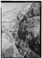 | 3,570 × 5,000 (17.03 MB) | Fæ (talk | contribs) | GWToolset: Creating mediafile for Fæ. HABS 2014-08-02 (3401:3600) |
You cannot overwrite this file.
File usage on Commons
The following page uses this file: