File:MINUSMA- Deployment Map (June 2017).pdf

Original file (1,650 × 1,275 pixels, file size: 528 KB, MIME type: application/pdf)
Captions
Captions
Summary[edit]
| Description |
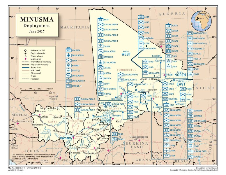
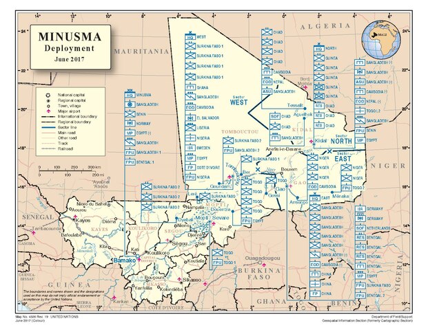
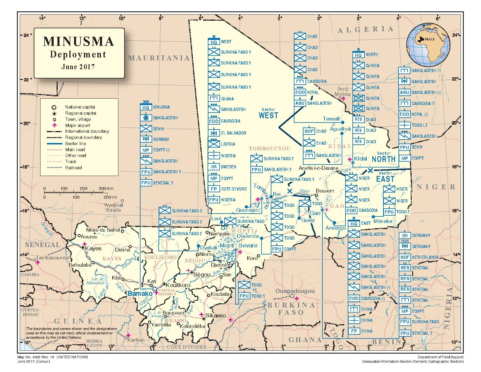
English: MINUSMA- Deployment Map
Deutsch: MINUSMA- Kräftedislozierung |
| Date | |
| Source | http://www.un.org/Depts/Cartographic/map/dpko/MINUSMA.pdf |
| Author | United Nations Geospatial Information Section ICTD Department of Field Support |
The Geospatial Information Section (formerly Cartographic Section) is comprised of a team of experienced mapping and GIS specialists. It is equipped to undertake a range of geospatial and cartographic services related to the work of the Secretariat, including the preparation of small-scale illustrative, large-scale stand-alone maps and GIS products. To a lesser extent, the section provides advisory geographic/cartographic services on technical and research issues.
As the geospatial authority for the Organization, the Section formulates geospatial standards and provides the necessary clearance for maps published under the UN imprint (Guidelines for the Publication of Maps, ST/AI/189/Add.25/Rev.1).
Many maps produced by the Section are an integral part of UN documents; some are prepared for briefing purposes only; and others are prepared for use by the Security Council and not for general distribution. Each map has a unique number that appears in the lower left-hand corner. This number is used to archive and retrieve maps in the Geospatial Information Section. Most digitally-prepared, current maps can be downloaded from this site, and are also available for reference in the Map Collection.
To date, no complete catalogue of United Nations maps has been published. However, most UN maps are referenced in the Dag Hammarskjöld Library's United Nations Bibliographic Information System (UNBIS), and may be searched by map number, geographical area and subject descriptors.
- Publication permissions for maps
Please read the rules for using UN maps in your publications and forward your request.
UN maps are open source material and you can use them in your work or for making your own map. We request however that you delete the UN name and reference number upon any modification to the map. Content of your map will be your responsibility. You can state in your publication if you wish something like: based on UN map…
If you want to use the UN map (or maps) as a UN document, i.e. without modification in specific publication, book or article we can issue publication permission on behalf of the UN Publication Board. It is free of charge and is conducted via email. Please tell us a few words about your forthcoming publication along with a list of the UN maps you would like to use.
Please do not reference the map by URL; instead provide the map name, map number, revision number and date. This information can be found at the lower left corner of each publication.
Licensing[edit]

|
The copyright holder of this work allows anyone to use it for any purpose including unrestricted redistribution, commercial use, and modification.
Usage notes:
|
File history
Click on a date/time to view the file as it appeared at that time.
| Date/Time | Thumbnail | Dimensions | User | Comment | |
|---|---|---|---|---|---|
| current | 18:40, 24 June 2017 |  | 1,650 × 1,275 (528 KB) | Schusterjunge 2 (talk | contribs) | {{Information |Description ={{en|1=MINUSMA- Deployment Map}} {{de|1=MINUSMA- Kräftedislozierung}} |Source =http://www.un.org/Depts/Cartographic/map/dpko/MINUSMA.pdf |Author =United Nations Geospatial Information Section ICTD Departm... |
You cannot overwrite this file.
File usage on Commons
The following 2 pages use this file:
- Maps of Mali
- File:MINUSMA.pdf (file redirect)
File usage on other wikis
The following other wikis use this file:
- Usage on ca.wikipedia.org
- Usage on de.wikipedia.org
- Usage on fr.wikipedia.org
- Usage on nl.wikipedia.org
- Usage on www.wikidata.org
Metadata
- Maps of Mali
- United Nations Multidimensional Integrated Stabilization Mission in Mali
- Nioro du Sahel
- Maps of Tombouctou Region
- Maps of Kayes Region
- Maps of Kidal Region
- Maps of Gao Region
- Maps of Mopti Region
- Maps of Koulikoro Region
- Maps of Ségou Region
- Maps of Sikasso Region
- Maps of Ménaka Region
- Koro, Mali
- Bourem, Mali
- Yanfolila, Mali
- Kolondiéba, Mali
- Nampala (Mali)
- Military maps
- June 2017 in Africa