Category:Maps of Mali
Jump to navigation
Jump to search
Countries of Africa: Algeria · Angola · Benin · Botswana · Burkina Faso · Burundi · Cameroon · Cape Verde · Central African Republic · Chad · Comoros · Democratic Republic of the Congo · Republic of the Congo · Djibouti · Egypt‡ · Equatorial Guinea · Eritrea · Eswatini · Ethiopia · Gabon · The Gambia · Ghana · Guinea · Guinea-Bissau · Ivory Coast · Kenya · Lesotho · Liberia · Libya · Madagascar · Malawi · Mali · Mauritania · Mauritius · Morocco · Mozambique · Namibia · Niger · Nigeria · Rwanda · São Tomé and Príncipe · Senegal · Seychelles · Sierra Leone · Somalia · South Africa · South Sudan · Sudan · Tanzania · Togo · Tunisia · Uganda · Zambia · Zimbabwe
Limited recognition: Ambazonia · Azawad · Puntland · Sahrawi Arab Democratic Republic · Somaliland – Other areas: Canary Islands · Ceuta · Madeira · Mayotte · Melilla · Réunion · Saint Helena, Ascension and Tristan da Cunha · Scattered Islands in the Indian Ocean · Western Sahara
‡: partly located in Africa
English: Maps of Mali
Français : Cartes du Mali
Wikimedia category | |||||
| Upload media | |||||
| Instance of | |||||
|---|---|---|---|---|---|
| Category combines topics | |||||
 | |||||
Subcategories
This category has the following 31 subcategories, out of 31 total.
- Blank maps of Mali (3 F)
A
- Maps of Mali in art (2 F)
B
- Maps of Bamako (10 F)
- Maps of borders of Mali (5 F)
C
- Cercle maps of Mali (96 F)
- CIA World Factbook maps of Mali (17 F)
D
- Maps of Djenné (3 F)
E
- ECHO Daily Maps of Mali (25 F)
- Election maps of Mali (3 F)
F
G
- Geological maps of Mali (2 F)
H
L
- Location maps of Mali (5 F)
- Locator maps of cities in Mali (48 F)
- Locator maps of communes in Mali (685 F)
M
O
- OpenStreetMap maps of Mali (5 F)
R
T
W
Pages in category "Maps of Mali"
The following 2 pages are in this category, out of 2 total.
Media in category "Maps of Mali"
The following 103 files are in this category, out of 103 total.
-
-
 20141203 ECHO SAHEL Projection Food Insecurity Jan-Mar2015.pdf 2,100 × 1,575; 637 KB
-
 20141203 ECHO SAHEL Projection Food Insecurity Jan-Mar2015.png 1,344 × 1,008; 462 KB
-
 20141204 ECHO Acute malnutrition 2014 GAM Editable A4 Landscape.pdf 1,754 × 1,239; 235 KB
-
 20141204 ECHO Acute malnutrition 2014 GAM Editable A4 Landscape.png 1,123 × 794; 256 KB
-
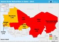 20141204 ECHO Acute malnutrition 2014 SAM Editable A4 Landscape.pdf 1,754 × 1,239; 231 KB
-
 20141204 ECHO Acute malnutrition 2014 SAM Editable A4 Landscape.png 1,123 × 794; 247 KB
-
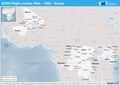 20160428 ECHO Flight.pdf 1,754 × 1,239; 445 KB
-
 20160428 ECHO Flight.png 1,123 × 794; 898 KB
-
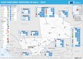 20160518 Mali ECHO 2016 Partners.pdf 1,754 × 1,239; 610 KB
-
 20160518 Mali ECHO 2016 Partners.png 1,123 × 794; 711 KB
-
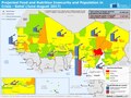
 20161209 ECHO PeopleAffectedConflict 2017 edit.pdf 2,100 × 1,575; 1.29 MB
-
 20161209 ECHO PeopleAffectedConflict 2017 edit.png 1,344 × 1,008; 590 KB
-
 20170109 ECHO PeopleAffectedConflict 2017 edit.pdf 2,100 × 1,575; 1.29 MB
-
 20170109 ECHO PeopleAffectedConflict 2017 edit.png 1,344 × 1,008; 593 KB
-
 20170413 ECHO PeopleAffectedConflict 2017 Sahel.pdf 2,100 × 1,575; 1.23 MB
-
 20170413 ECHO PeopleAffectedConflict 2017 Sahel.png 1,344 × 1,008; 587 KB
-
 20210617 Mali Operational Map v3(1).pdf 1,754 × 1,239; 1.37 MB
-
 20210617 Mali Operational Map v3(1).png 3,508 × 2,481; 4.16 MB
-
 20210826 WestCentralAfrica ComplexRegionalCrisis HIP2022(3).pdf 1,754 × 1,239; 1.12 MB
-
 20210826 WestCentralAfrica ComplexRegionalCrisis HIP2022(3).png 3,509 × 2,482; 7.16 MB
-
 20230530 West & Central Africa Complex Crisis(1).pdf 1,754 × 1,239; 728 KB
-
 20230530 West & Central Africa Complex Crisis(1).png 3,509 × 2,482; 10.26 MB
-
 20230627 Mali ECHO Response(1).pdf 1,754 × 1,239; 624 KB
-
 20230627 Mali ECHO Response(1).png 1,123 × 794; 340 KB
-
 20231212 Mali Humanitarian Crisis Dec23.pdf 1,754 × 1,239; 555 KB
-
 20231212 Mali Humanitarian Crisis Dec23.png 3,508 × 2,481; 7.54 MB
-
 Africa SPOT jul04jul05.jpg 540 × 734; 44 KB
-
 Algeria-Mauritania boundary.jpg 4,137 × 3,171; 9.76 MB
-
 AT0903 map.png 527 × 423; 42 KB
-
 Azawad in context.JPG 600 × 669; 42 KB
-
 Bamako cercle.png 1,056 × 816; 21 KB
-
 Commune de Menamba1.jpg 2,924 × 2,068; 428 KB
-
 Dire cercle.png 840 × 414; 143 KB
-
 ECDM 20141210 WestAfrica Ebola Disease Outbreack.pdf 1,625 × 1,125; 519 KB
-
 ECDM 20150527 World Events.pdf 1,625 × 1,125; 472 KB
-
 ECDM 20150812 World events.pdf 1,625 × 1,125; 684 KB
-
 ECDM 20150820 World Events.pdf 1,625 × 1,125; 453 KB
-
 ECDM 20151007 Worldevents.pdf 1,625 × 1,125; 614 KB
-
 ECDM 20160610 World events.pdf 1,625 × 1,125; 567 KB
-
 ECDM 20180723 Burkina-Faso Crisis.pdf 1,754 × 1,239; 837 KB
-
 ECHO Mali Editable A4 Landscape.pdf 1,754 × 1,239; 423 KB
-
 ECHO Mali Editable A4 Landscape.png 1,123 × 794; 383 KB
-
 ECHO Sahel Basemap A3 Landscape 2016 v2.pdf 1,754 × 1,239; 492 KB
-
 ECHO Sahel Basemap A3 Landscape 2016 v2.png 1,123 × 794; 557 KB
-
 ECHO Sahel Basemap A3 Landscape.png 4,959 × 3,509; 748 KB
-
 FLII Mali.png 1,545 × 816; 120 KB
-
 Goundam cercle.png 1,047 × 1,563; 292 KB
-
 Gourma Rharous cercle.png 834 × 426; 157 KB
-
 Karte Mali.png 3,007 × 3,225; 657 KB
-
 Un-mali Kayes Region.png 692 × 594; 208 KB
-
 Kouroukoto.png 477 × 482; 118 KB
-
 Localisation de Ogossagou (Mali) dans la région de Bankass.gif 1,000 × 670; 61 KB
-
 Localisation de Tominian Mali.png 449 × 443; 10 KB
-
 Mali - DPLA - 0622f66f0e2ed08ae2397e0da05d21dc.jpg 3,274 × 2,550; 1.2 MB
-
 Mali - DPLA - cb5613839f8722f03e3c4ce7c8735bcc.jpg 2,554 × 3,272; 5.35 MB
-
 Mali - DPLA - f1133ccc399a5eb8d0414403b5d28674.jpg 2,554 × 3,276; 6.4 MB
-
 Mali - Location Map (2013) - MLI - UNOCHA.png 2,000 × 2,000; 346 KB
-
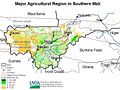 Mali ag map 2001 USDA.jpg 787 × 590; 130 KB
-
 Mali arrondissements.png 1,083 × 996; 63 KB
-
 Mali Azauad.png 778 × 835; 76 KB
-
 Mali Azavad.png 778 × 835; 80 KB
-
 Mali cercles svg.svg 1,294 × 1,208; 116 KB
-
 Mali cercles.png 1,070 × 998; 45 KB
-
 MALI empire BLANK.PNG 1,580 × 988; 60 KB
-
 MALI empire BLANK.svg 1,668 × 1,214; 43 KB
-
 Mali Population Density, 2000 (5457016047).jpg 2,550 × 3,216; 644 KB
-
 Mali Population Density, 2000 (6171913629).jpg 2,394 × 3,160; 643 KB
-
 Mali regions map.png 2,108 × 2,000; 650 KB
-
 Mali zonas protegidas.jpg 1,900 × 1,812; 1.65 MB
-
 Mali-Bamako.png 200 × 187; 4 KB
-
 Mali-géo.png 322 × 313; 15 KB
-
 MINUSMA MAP Dec 2018.png 806 × 615; 376 KB
-
 MINUSMA- Deployment Map (June 2017).pdf 1,650 × 1,275; 528 KB
-
 Mopti Region.png 1,023 × 575; 140 KB
-
 Niafunke cercle.png 923 × 416; 154 KB
-
 Region of Gao 2016.png 1,070 × 998; 21 KB
-
 Region of Taoudénit 2016.png 1,070 × 998; 21 KB
-
 Region of Tombouctou 2016.png 1,070 × 998; 21 KB
-
 Regions of mali (AR).png 775 × 833; 124 KB
-
 Regions of Mali 2016 (2).png 1,070 × 998; 33 KB
-
 Regions of Mali 2016.png 1,070 × 998; 38 KB
-
 Sahel Base Map v2.png 954 × 703; 503 KB
-
 Sahel Base Map.png 4,227 × 3,136; 641 KB
-
 Selloù disheñvel ouzh an Azawad.png 558 × 600; 97 KB
-
 Senegal-mali1887-1890.png 3,500 × 1,387; 1.02 MB
-
 Senegal-mali1890a.png 3,500 × 1,384; 896 KB
-
 Senegal-mali1890b.png 3,500 × 1,384; 892 KB
-
 Senegal-mali1890c.png 3,500 × 1,385; 934 KB
-
 Senegal-mali1891a.png 3,499 × 1,384; 941 KB
-
 Senegal-mali1891b.png 3,499 × 1,384; 1.01 MB
-
 Senegal-mali1891c.png 3,500 × 1,410; 1.02 MB
-
 Senegal-mali1892.png 3,500 × 1,430; 1.08 MB
-
 Senegal-mali1893.png 3,500 × 1,430; 1,016 KB
-
 Tessalit.jpg 300 × 279; 89 KB
-
 Tombouctou cercle.png 1,047 × 1,563; 293 KB
-
 Tombouctou region UN map.png 1,047 × 1,563; 290 KB
-
 Un-koulikoro region.png 660 × 726; 237 KB
-
 Un-mali.png 3,092 × 2,367; 2.11 MB
-
 WestCentral Africa Complex Crisis map.pdf 1,754 × 1,239; 753 KB
-
 WestCentral Africa Complex Crisis map.png 1,123 × 794; 1.28 MB
-
 AT0722 map.png 1,316 × 844; 48 KB
-
 Zh MALI empire map.png 1,580 × 994; 46 KB
%27_(11147246953).jpg)


.png)
.png)
.png)
.png)


_dans_la_r%C3%A9gion_de_Bankass.gif)


_-_MLI_-_UNOCHA.png)


.jpg)
.jpg)


.png)
.png)


