File:Maastricht1749LarcherDAubencourt2.jpg
Jump to navigation
Jump to search

Size of this preview: 800 × 596 pixels. Other resolutions: 320 × 238 pixels | 640 × 477 pixels | 1,024 × 763 pixels | 1,280 × 953 pixels | 2,560 × 1,907 pixels | 2,908 × 2,166 pixels.
Original file (2,908 × 2,166 pixels, file size: 2.37 MB, MIME type: image/jpeg)
Captions
Captions
Add a one-line explanation of what this file represents
Summary
[edit]| Description |
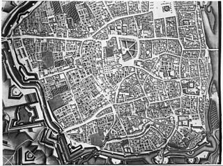
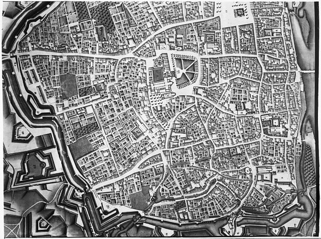
English: Maastricht, the Netherlands. Part of a map showing the southwestern part of the city in 1749. The map by French military engineer Jean-Baptiste Larcher d'Aubencourt was used to build the Maquette of Maastricht (1752), now in the Musée de Beaux Arts in Lille, France. The map (or a copy?) is in the collection of RHCL archives, Maastricht. |
| Date | |
| Source | http://beeldbank.cultureelerfgoed.nl/alle-afbeeldingen/weergave/search/layout/result/indeling/detail/start/2?searchfield=Larcher+d%5C%5C%5C%27Aubancourt |
| Author | Jean-Baptiste Larcher d'Aubencourt (1716–1796) |
| Other versions |
.jpg)
.jpg)
.jpg)
.jpg)
Licensing
[edit]
|
This work is in the public domain in its country of origin and other countries and areas where the copyright term is the author's life plus 100 years or fewer. | |
| This file has been identified as being free of known restrictions under copyright law, including all related and neighboring rights. | |
File history
Click on a date/time to view the file as it appeared at that time.
| Date/Time | Thumbnail | Dimensions | User | Comment | |
|---|---|---|---|---|---|
| current | 11:22, 24 February 2014 | | 2,908 × 2,166 (2.37 MB) | Kleon3 (talk | contribs) | User created page with UploadWizard |
You cannot overwrite this file.
File usage on Commons
The following 4 pages use this file:
File usage on other wikis
The following other wikis use this file:
- Usage on nl.wikipedia.org