File:Malaspina Glacier ESA362703.tiff

Original file (4,189 × 5,000 pixels, file size: 47.18 MB, MIME type: image/tiff)
Captions
Captions
Summary
[edit]| Description |
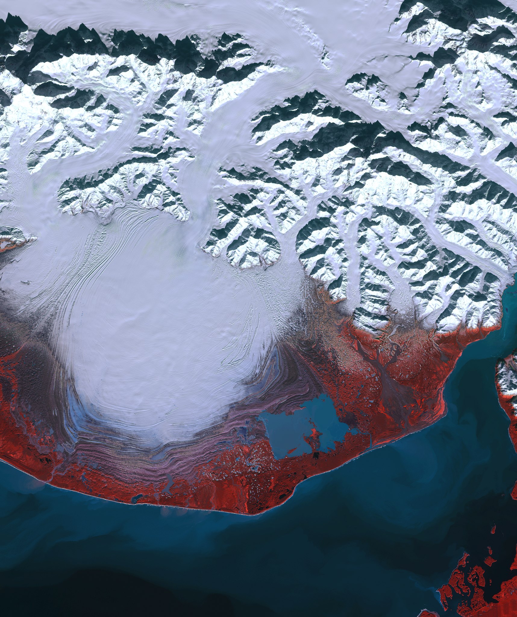
English: The Sentinel-2A satellite takes us over southeastern Alaska to the Malaspina Glacier.
The climate and topography of this area over the last 12.5 million years have been favourable for glaciers. During the Ice Age, a vast ice sheet covered this spot. When temperatures rose, an interglacial period began. The coastal mountains and the maritime climate of this area provide the perfect setting for glaciation: some of the world’s longest and most spectacular glaciers are found here. Malaspina is a piedmont glacier – meaning that ice flows down a steep valley and spills out onto a relatively flat plain. It is the largest of its kind, with an area of about 3900 sq km. In this false-colour image, red depicts vegetated areas while purple shows rock. The wavy purple lines around the lower half of the glacier are rock, soil and other debris that have been deposited by the glacier – called moraines. Satellite data show that the elevation of Malaspina has dropped over the past decades, and this ice loss has made a significant contribution to sea-level rise. This image, also featured on theEarth from Space video programme, was acquired on 8 March 2016. The low Sun level at Alaska’s high latitudes during this season is evident by the shadows cast north by the Elias Mountains. |
| Date | |
| Source | http://www.esa.int/spaceinimages/Images/2016/07/Malaspina_Glacier |
| Author | European Space Agency |
| Permission (Reusing this file) |
Contains modified Copernicus Sentinel data (2016), processed by ESA,CC BY-SA 3.0 IGO |
| Other versions |
|
| Title | Malaspina Glacier |
| Set | Earth observation image of the week |
| System | Copernicus |
| Mission | Sentinel-2 |
| Location | USA |
| Activity | Observing the Earth |
| Keywords | Glaciers; Ice |

Licensing
[edit]- You are free:
- to share – to copy, distribute and transmit the work
- to remix – to adapt the work
- Under the following conditions:
- attribution – You must give appropriate credit, provide a link to the license, and indicate if changes were made. You may do so in any reasonable manner, but not in any way that suggests the licensor endorses you or your use.
- share alike – If you remix, transform, or build upon the material, you must distribute your contributions under the same or compatible license as the original.

|
This image contains data from a satellite in the Copernicus Programme, such as Sentinel-1, Sentinel-2 or Sentinel-3. Attribution is required when using this image.
Attribution: Contains modified Copernicus Sentinel data {{{year}}}
The use of Copernicus Sentinel Data is regulated under EU law (Commission Delegated Regulation (EU) No 1159/2013 and Regulation (EU) No 377/2014). Relevant excerpts:
Free access shall be given to GMES dedicated data [...] made available through GMES dissemination platforms [...].
Access to GMES dedicated data [...] shall be given for the purpose of the following use in so far as it is lawful:
GMES dedicated data [...] may be used worldwide without limitations in time.
GMES dedicated data and GMES service information are provided to users without any express or implied warranty, including as regards quality and suitability for any purpose. |
File history
Click on a date/time to view the file as it appeared at that time.
| Date/Time | Thumbnail | Dimensions | User | Comment | |
|---|---|---|---|---|---|
| current | 12:06, 7 May 2017 |  | 4,189 × 5,000 (47.18 MB) | Fæ (talk | contribs) | == {{int:filedesc}} == {{information | description = {{en|1=The Sentinel-2A satellite takes us over southeastern Alaska to the Malaspina Glacier. The climate and topography of this area over the last 12.5 million years have been favourable for glaciers... |
You cannot overwrite this file.
File usage on Commons
The following page uses this file: